

Rabbit Flat, Northern Territory
Encyclopedia
Northern Territory
The Northern Territory is a federal territory of Australia, occupying much of the centre of the mainland continent, as well as the central northern regions...
of Australia
Australia
Australia , officially the Commonwealth of Australia, is a country in the Southern Hemisphere comprising the mainland of the Australian continent, the island of Tasmania, and numerous smaller islands in the Indian and Pacific Oceans. It is the world's sixth-largest country by total area...
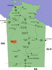
about 160 kilometres (99.4 mi) from the Western Australia
Western Australia
Western Australia is a state of Australia, occupying the entire western third of the Australian continent. It is bounded by the Indian Ocean to the north and west, the Great Australian Bight and Indian Ocean to the south, the Northern Territory to the north-east and South Australia to the south-east...
border.
Roadhouse
The Rabbit Flat Roadhouse is claimed to be the most isolated roadhouseRoadhouse (facility)
A roadhouse is a commercial establishment typically built on a major road or highway, to service passing travellers. Its meaning varies slightly by country.-USA:...
in Australia, with no other roadhouses within 100 kilometres (62.1 mi). It is located about 2 kilometres (1.2 mi) from the Tanami Road formerly known as the Tanami Track which runs from Alice Springs
Alice Springs, Northern Territory
Alice Springs is the second largest town in the Northern Territory of Australia. Popularly known as "the Alice" or simply "Alice", Alice Springs is situated in the geographic centre of Australia near the southern border of the Northern Territory...
in central Australia northwest to Halls Creek
Halls Creek, Western Australia
Halls Creek is a small town situated in the East Kimberley region of Western Australia. It is located between the towns of Fitzroy Crossing and Turkey Creek on the Great Northern Highway...
in the Kimberley region of Western Australia
Western Australia
Western Australia is a state of Australia, occupying the entire western third of the Australian continent. It is bounded by the Indian Ocean to the north and west, the Great Australian Bight and Indian Ocean to the south, the Northern Territory to the north-east and South Australia to the south-east...
.
Rabbit Flat is between the Tanami Mine (45 km NW) and The Granites Mine (53 km SE) on the Tanami Road. It was established on 14 June 1969 by Bruce Farrands and his wife Jackie, a French national. An arrangement had been agreed between the Farrands and Ansett-Pioneer Coaches to provide overnight tent accommodation for a tourist route between Alice Springs and Darwin
Darwin, Northern Territory
Darwin is the capital city of the Northern Territory, Australia. Situated on the Timor Sea, Darwin has a population of 127,500, making it by far the largest and most populated city in the sparsely populated Northern Territory, but the least populous of all Australia's capital cities...
via Wave Hill, now known as Kalkaringi.
The location was chosen due to the availability of water at Rabbit Flat well, which was on the stock route
Stock route
In Australia, the Travelling Stock Route is an authorised thoroughfare for the walking of domestic livestock such as sheep or cattle from one location to another...
from Alice Springs to Halls Creek.
By December 1969, Rabbit Flat had been selected as a weather reporting station by the Bureau of Meteorology
Bureau of Meteorology
The Bureau of Meteorology is an Executive Agency of the Australian Government responsible for providing weather services to Australia and surrounding areas. It was established in 1906 under the Meteorology Act, and brought together the state meteorological services that existed before then...
. The roadhouse became a stop for fuel, food and souvenirs as time progressed. An orchard of citrus trees grows nearby, as the weather conditions are suitable, so jams and preservatives are produced on site.
On the morning of 6 August 1975, intense media interest was aroused when twin boys were born to the Farrands at the Rabbit Flat Roadhouse. Neither the surprised parents nor medical staff in Alice Springs were aware that more than one baby was expected. Mother Jackie and the babies were flown to Alice Springs hospital by the Royal Flying Doctor Service of Australia
Royal Flying Doctor Service of Australia
The Royal Flying Doctor Service of Australia is an emergency and primary health care service for those living in rural, remote and regional areas of Australia...
for observation, as the boys were six weeks premature. The pilot of the RFDS aircraft is reported to have quipped on arrival in Alice Springs, "the population of Rabbit Flat doubled last night". A documentary film was produced about Rabbit Flat by the Australian Broadcasting Corporation
Australian Broadcasting Corporation
The Australian Broadcasting Corporation, commonly referred to as "the ABC" , is Australia's national public broadcaster...
for their television series A Big Country.
Closure of the Roadhouse
After more than 41 years of service, the Farrands decided to close the roadhouse to all services except weather reporting and the sale of souvenirs and preservatives. It was closed on 31 December 2010, however the roadhouse opened an online store selling their souvenirs and preserves in late 2011.Weather station
The roadhouse manager maintains the weather station at Rabbit Flat, the closest climatic station being at BalgoBalgö
Balgö is an island and a nature reserve in Kattegat, off Tångaberg in Varberg Municipality, Sweden. Balgö is the larges island in Halland. The nature reserve was established in 1950. Some smaller islands around Balgö are also included in the nature reserve....
, a small Aboriginal community 212 kilometres (131.7 mi) to the West; the airstrip is 00.8 kilometre (0.497098189319845 mi) away.
Map reference
- Westprint Heritage Maps.(2002) Tanami Track: Alice Springs, The Granites, Rabbit Flat, Billiluna, Halls Creek / compiled by John Deckert ; cartographic design and production by Flat Earth Mapping. 3rd ed. Scale 1:1,000,000 (E 127°20’ -- E 134°00’/S 17°25’ --S 24°00’) Nhill, Vic. : Westprint Heritage Maps. ISBN 9781875608119 also known as Westprint Heritage Maps for modern explorers.