
Pulletop bushfire
Encyclopedia
Pulletop
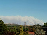
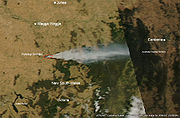
bushfire started on the 6 February 2006 in hot dry and windy weather conditions about 30 km southeast of Wagga Wagga, New South Wales
. The fire was thought to have been started by sparks from a tractor on a property at Pulletop which quickly got out of control. New South Wales Rural Fire Service
declared a bushfire emergency and the Hume Highway
was closed late in the afternoon with fears that the fire would threaten the towns of Humula
, Book Book
, Livingstone and Kyeamba
after 10 km² of farmland was burnt. 7 February 2006 milder conditions help firefighters to control the fire burning in inaccessible country.
Pulletop, New South Wales
Pulletop is a rural locality in the south eastern part of the Riverina - it was previously called "Pullitop". It is situated by road, about 5 kilometres east south-east from Burrandana and 9 kilometres north from Westby.-Notes and references:...
bushfire started on the 6 February 2006 in hot dry and windy weather conditions about 30 km southeast of Wagga Wagga, New South Wales
Wagga Wagga, New South Wales
Wagga Wagga is a city in New South Wales, Australia. Straddling the Murrumbidgee River, and with an urban population of 46,735 people, Wagga Wagga is the state's largest inland city, as well as an important agricultural, military, and transport hub of Australia...
. The fire was thought to have been started by sparks from a tractor on a property at Pulletop which quickly got out of control. New South Wales Rural Fire Service
New South Wales Rural Fire Service
The New South Wales Rural Fire Service is a volunteer-based firefighting agency and statutory body of the NSW Government. The NSW RFS is responsible for the general administration of rural fire management affairs including administration of the Rural Fire Fighting Fund, co-ordination with local...
declared a bushfire emergency and the Hume Highway
Hume Highway
The Hume Highway/Hume Freeway is one of Australia's major inter-city highways, running for 880 km between Sydney and Melbourne. It is part of the Auslink National Network and is a vital link for road freight to transport goods to and from the two cities as well as serving Albury-Wodonga and...
was closed late in the afternoon with fears that the fire would threaten the towns of Humula
Humula, New South Wales
Humula is a small country town between Tarcutta and Tumbarumba in New South Wales, Australia. Humula Station, which is just outside the town, is one of Australia's most historic farming and grazing properties. Humula was once named "American Yards" or "American Fields" during the gold rush, where...
, Book Book
Book Book, New South Wales
Book Book is a rural community in the central east part of the Riverina. It is situated about 12 kilometres north from Kyeamba and 15 kilometres south from Ladysmith.thumb|200px|left|Book Book Tennis Courts...
, Livingstone and Kyeamba
Kyeamba, New South Wales
Kyeamba is a farming community in the central east part of the Riverina and situated about 16 kilometres north west from Humula and 23 kilometres north east from Tarcutta. At the 2006 census, Kyeamba had a population of 212...
after 10 km² of farmland was burnt. 7 February 2006 milder conditions help firefighters to control the fire burning in inaccessible country.
- Over 90 km² of farmland burnt
- 2,500 sheep killed
- 6 cattle killed
- 3 vehicles destroyed
- 2 hay sheds destroyed
- 50km of fencing was burnt
- Pine plantation worth $Australian dollarThe Australian dollar is the currency of the Commonwealth of Australia, including Christmas Island, Cocos Islands, and Norfolk Island, as well as the independent Pacific Island states of Kiribati, Nauru and Tuvalu...
5 million, a communications installation and 19 homes saved - A Natural Disaster was declared