
Portable Collision Avoidance System
Encyclopedia
Portable Collision Avoidance System (PCAS) is an aircraft collision avoidance system similar in function to traffic collision avoidance system
(TCAS). TCAS is the industry standard for commercial collision avoidance systems but PCAS is gaining recognition as an effective means of collision avoidance for general aviation and is in use the world over by independent pilots in personally owned or rented light aircraft as well as by flight schools and flying clubs.
Simply put PCAS allows pilots, particularly in single pilot VFR
aircraft in uncontrolled airspaces, a powerful additional instrument to augment their vision and situational awareness of other aircraft operating in their vicinity. A basic system will notify pilots of the nearest transponder equipped aircraft, its relative height and distance, and importantly if the distances are closing or increasing. More advanced systems can integrate with EFIS
overlaying nearby aircraft on the GPS map with relative height information. This information not only reduces pilot work loads in busy airspace but also helps pilots to hone their ability to spot nearby aircraft by alerting them when an aircraft is within a range that it might normally go unnoticed.
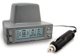
PCAS is a trademark of Zaon Flight Systems, Inc. The original PCAS technology was developed in 1999 and today the fourth generation of PCAS technology is in use. Through this technology, transponder-equipped aircraft are detected and ranged, and the altitude is decoded. PCAS G4 technology has advanced to the point that highly accurate range, relative altitude, and 45 degree direction can be accurately detected in a portable cockpit device. PCAS has gained notoriety with the growing popular TV series The Aviators (TV series)
as a sponsor, and specifically in episode 6 airing on both PBS and the Discovery Channel Network.
 ATC ground stations and active TCAS systems transmit interrogation pulses on an uplink frequency of 1,030 megahertz. Aircraft transponders reply on a downlink frequency of 1,090 megahertz. PCAS devices detect these transponder responses, then analyze and display conflict information.
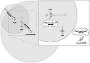 To start the cycle, an interrogation is sent out from ground-based RADAR stations and/or TCAS or other actively interrogating systems in your area. This signal is sent on 1,030 MHz. For TCAS, this interrogation range can have a radius of 40 miles from the interrogation source. The Ground RADAR range can be 200 miles or more.
 The transponder on any aircraft within range of the interrogation replies on 1090 MHz with their squawk code (known as mode A) and altitude code (or mode C). The altitude information is sent in an encoded format.
Mode S transponders also reply on this frequency, and encoded within the mode S transmission is the mode A (squawk) and mode C (altitude) information.
Military aircraft also respond on this frequency but use a different transmission protocol (see Step 3).
Your aircraft's transponder should also reply. However, the XRX unit watches for this signal and will not report it as a threat aircraft. The unit may use this information to establish base altitude for use in step 4.
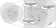
 Any aircraft reply within the XRX detection window (maximum 6 miles) will be received. The range is computed based on the amplitude of the received signal, the altitude code is decoded, and the signal angle-of-arrival is determined. XRX will recognize interrogations from TCAS, Skywatch, and any other "active" system, military protocols, and Mode S transmissions.
The greatest threat is determined by looking at aircraft within the detection window you set up and comparing primarily the vertical separation (± relative altitude), and secondarily the range to the aircraft currently being displayed. XRX uses algorithms to determine which of two or more aircraft is a greater threat.
Traffic Collision Avoidance System
A traffic collision avoidance system or traffic alert and collision avoidance system is an aircraft collision avoidance system designed to reduce the incidence of mid-air collisions between aircraft...
(TCAS). TCAS is the industry standard for commercial collision avoidance systems but PCAS is gaining recognition as an effective means of collision avoidance for general aviation and is in use the world over by independent pilots in personally owned or rented light aircraft as well as by flight schools and flying clubs.
Simply put PCAS allows pilots, particularly in single pilot VFR
Visual flight rules
Visual flight rules are a set of regulations which allow a pilot to operate an aircraft in weather conditions generally clear enough to allow the pilot to see where the aircraft is going. Specifically, the weather must be better than basic VFR weather minimums, as specified in the rules of the...
aircraft in uncontrolled airspaces, a powerful additional instrument to augment their vision and situational awareness of other aircraft operating in their vicinity. A basic system will notify pilots of the nearest transponder equipped aircraft, its relative height and distance, and importantly if the distances are closing or increasing. More advanced systems can integrate with EFIS
Electronic Flight Instrument System
An electronic flight instrument system is a flight deck instrument display system in which the display technology used is electronic rather than electromechanical. EFIS normally consists of a primary flight display , multi-function display and engine indicating and crew alerting system display...
overlaying nearby aircraft on the GPS map with relative height information. This information not only reduces pilot work loads in busy airspace but also helps pilots to hone their ability to spot nearby aircraft by alerting them when an aircraft is within a range that it might normally go unnoticed.
PCAS is a trademark of Zaon Flight Systems, Inc. The original PCAS technology was developed in 1999 and today the fourth generation of PCAS technology is in use. Through this technology, transponder-equipped aircraft are detected and ranged, and the altitude is decoded. PCAS G4 technology has advanced to the point that highly accurate range, relative altitude, and 45 degree direction can be accurately detected in a portable cockpit device. PCAS has gained notoriety with the growing popular TV series The Aviators (TV series)
The Aviators (TV series)
The Aviators is a new weekly magazine-style TV series featuring interesting people, the latest aircraft, current technology and fly-in destinations. The show's site describes subject matter as follows: "We will take you behind the scenes to show you how airline pilots train, how planes are built,...
as a sponsor, and specifically in episode 6 airing on both PBS and the Discovery Channel Network.
Basic operation
Differences between PCAS and TCAS/TIS
PCAS is passive, portable, and much less expensive than traditional aircraft detection systems, such as TCAS, L3 Skywatch and Ryan TCAD. TCAS is an active system transmitting interrogation pulses and monitoring responses. TIS requires the use of ground based mode S sensor sites which will then transmit traffic information to mode S client systems. Several US sensor sites are scheduled for closure and the TIS service is generally unavailable in Canada. TCAS operates with more precision than PCAS but is also significantly more expensive. A very well known general aviation organization completed an evaluation of the PCAS XRX system to demonstrate the capabilities.Step 1
Step 2
Mode S transponders also reply on this frequency, and encoded within the mode S transmission is the mode A (squawk) and mode C (altitude) information.
Military aircraft also respond on this frequency but use a different transmission protocol (see Step 3).
Your aircraft's transponder should also reply. However, the XRX unit watches for this signal and will not report it as a threat aircraft. The unit may use this information to establish base altitude for use in step 4.
Step 3
Step 4
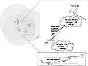
The altitude of the aircraft (in the example, 2,500 ft.) is compared to your local altitude (e.g., 1,500 ft.) and the relative altitude is calculated (e.g., 1,000 ft. above you). With relative direction, altitude and range determined, XRX displays this information and stores it in memory.Step 5
If additional aircraft are within detection range, the above process is repeated for each aircraft. The top threat is displayed on the left of the traffic screen and the second and third threats are displayed on the right.The greatest threat is determined by looking at aircraft within the detection window you set up and comparing primarily the vertical separation (± relative altitude), and secondarily the range to the aircraft currently being displayed. XRX uses algorithms to determine which of two or more aircraft is a greater threat.