
Poolbeg Lighthouse
Encyclopedia

Dublin Bay
Dublin Bay is a C-shaped inlet of the Irish Sea on the east coast of Ireland. The bay is about 10 kilometres wide along its north-south base, and 7 km in length to its apex at the centre of the city of Dublin; stretching from Howth Head in the north to Dalkey Point in the south...
was built in 1768 and initially operated on candlepower (reputedly the first in the world to do so) but changed to oil in 1786. It was re-designed and re-built into its present form in 1820.
Location
Lighthouse
A lighthouse is a tower, building, or other type of structure designed to emit light from a system of lamps and lenses or, in older times, from a fire, and used as an aid to navigation for maritime pilots at sea or on inland waterways....
, one of a formation of three, is located on the Great South Wall
Great South Wall
The Great South Wall , at the Port of Dublin, extends from Ringsend nearly four miles out into Dublin Bay. It was the world's longest sea-wall at the time of its building, remaining one of the longest in Europe...
(South Bull Wall), at the Port of Dublin
Dublin Port
Dublin Port is Ireland's biggest sea port. It has both historical and contemporary economic importance. Approximatively two-thirds of the Republic of Ireland's port traffic goes via Dublin Port...
, which extends from Ringsend
Ringsend
Ringsend is a southside inner suburb of Dublin, the capital of Ireland. It is located on the south bank of the River Liffey, about two kilometres east of the city centre, and is the southern terminus of the East Link Toll Bridge....
nearly four miles out into Dublin Bay
Dublin Bay
Dublin Bay is a C-shaped inlet of the Irish Sea on the east coast of Ireland. The bay is about 10 kilometres wide along its north-south base, and 7 km in length to its apex at the centre of the city of Dublin; stretching from Howth Head in the north to Dalkey Point in the south...
. The wall was the world's longest at the time of its building, and remains one of the longest sea-walls in Europe
Europe
Europe is, by convention, one of the world's seven continents. Comprising the westernmost peninsula of Eurasia, Europe is generally 'divided' from Asia to its east by the watershed divides of the Ural and Caucasus Mountains, the Ural River, the Caspian and Black Seas, and the waterways connecting...
. One of the other two lighthouses is located on the Bull Wall
Bull Wall
The Bull Wall, or North Bull Wall, at the Port of Dublin, extending from the estuary of the River Tolka and the district of Clontarf out nearly 3 km into Dublin Bay, is one of the two defining sea walls of the port, and faces the earlier-constructed Great South Wall...
opposite, and the other on a wooden platform mid-channel.
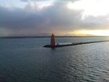
The Poolbeg Lighthouse is a handsome and conspicuous feature in the bay, in which it occupies an almost central position. It is nearly equidistant from Dublin, Dún Laoghaire
Dún Laoghaire
Dún Laoghaire or Dún Laoire , sometimes anglicised as "Dunleary" , is a suburban seaside town in County Dublin, Ireland, about twelve kilometres south of Dublin city centre. It is the county town of Dun Laoghaire-Rathdown County and a major port of entry from Great Britain...
, and Howth
Howth
Howth is an area in Fingal County near Dublin city in Ireland. Originally just a small fishing village, Howth with its surrounding rural district is now a busy suburb of Dublin, with a mix of dense residential development and wild hillside, all on the peninsula of Howth Head. The only...
, and commands extensive views of the shores of the bay, with an unbroken panorama of the mountains on the south. Howth with its heather-clad hills, its bright green fields and rugged reaches of sea cliffs, looks particularly attractive from this point.
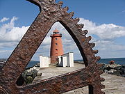
Original Building
Lighthouse
A lighthouse is a tower, building, or other type of structure designed to emit light from a system of lamps and lenses or, in older times, from a fire, and used as an aid to navigation for maritime pilots at sea or on inland waterways....
when originally constructed, presented an entirely different appearance from what it does at the present time. It was not so high as the existing structure, it sloped much more rapidly towards the top, and was surmounted by an octagonal lantern with eight heavy glass windows. A stone staircase with an iron balustrade led to the second storey, where an iron gallery surrounded the whole building.
The alteration to the present form was made in the early part of the nineteenth century.
Management
The lighthouse, automated for many years, is managed by Dublin Port Company, whereas most lighthouses in Ireland are managed by the Commissioners of Irish LightsCommissioners of Irish Lights
The Commissioners of Irish Lights is the body that serves as the lighthouse authority for Ireland plus its adjacent seas and islands...
, today part of a larger cross-border body.
Standard height measurement for Ordnance Survey Ireland
Historically, the Ordnance Survey IrelandOrdnance Survey Ireland
Ordnance Survey Ireland is the national mapping agency of the Republic of Ireland and, together with the Ordnance Survey of Northern Ireland , succeeded, after 1922, the Irish operations of the United Kingdom Ordnance Survey. It is part of the Public service of the Republic of Ireland...
used the low water mark of the spring tide on the 8th April 1837 at the Poolbeg Lighthouse as a standard height for all its maps, a practice which continued up until 1958.
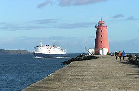
Colouring
The Poolbeg Lighthouse is painted red. The green lighthouse in Dublin bay is the North Bull lighthouse, a couple of yards off the end of the North Bull Wall, and another lighthouse sits out in the bay itself. Green is for starboard (right) and red is for portPort
A port is a location on a coast or shore containing one or more harbors where ships can dock and transfer people or cargo to or from land....
(left) - presumably its right and left as you enter Dublin port (travelling from west to east) so the north would be on your right/starboard and is therefore green and the south would be on your left/port and is therefore red.