
Ponitrie Protected Landscape Area
Encyclopedia
Ponitrie Protected Landscape Area is one of the 14 protected landscape areas in Slovakia
. The Landscape Area is situated in the Tribeč
and Vtáčnik
mountains, in western Slovakia. It is situated in the Nitra
, Zlaté Moravce
, Žarnovica
, Topoľčany
, Partizánske
and Prievidza
districts.
mountains. Beech and fir trees dominate in the area. The highest mountain is Vtáčnik at . Tribeč, in the south, is a crystalline mountain range built on granitoide rocks, limestone and dolomite. Beech, hornbeam and in higher locations oak forests are covering the area. The highest mountain is Veľký Tribeč at .
Slovakia
The Slovak Republic is a landlocked state in Central Europe. It has a population of over five million and an area of about . Slovakia is bordered by the Czech Republic and Austria to the west, Poland to the north, Ukraine to the east and Hungary to the south...
. The Landscape Area is situated in the Tribeč
Tribec
Tribeč is a crystalline mountain range in western Slovakia, in the Inner Western Carpathians within the Fatra-Tatra Area, roughly between the towns of Nitra, Partizánske and Zlaté Moravce. It is surrounded by the Danubian Lowland, Pohronský Inovec, Vtáčnik mountains and the Upper Nitra Basin. It is...
and Vtáčnik
Vtácnik
Vtáčnik is a mountain range in central Slovakia, which is part of the Slovenské stredohorie Mountains and part of the Inner Western Carpathians....
mountains, in western Slovakia. It is situated in the Nitra
Nitra District
Nitra District is a district inthe Nitra Region of western Slovakia. It is the most populated of Slovakia's 79 districts. Until 1918, most of the present-day district belonged to the Nitra county, apart from Vráble in the east which was part of the county of Tekov.- Municipalities...
, Zlaté Moravce
Zlaté Moravce District
Zlaté Moravce District is a district inthe Nitra Region of western Slovakia.Until 1918, the district formed mostly part of the Hungarian county of Tekov, apart from a small area in the west around Kostoľany pod Tribečom which formed part of the county of Nitra.- Municipalities...
, Žarnovica
Žarnovica District
Žarnovica District is a district inthe Banská Bystrica Region of central Slovakia. Until 1918, the district was mostly part of the Hungarian county of Tekov, only a part of Hodruša-Hámre, namely Banská Hodruša in the east was part of Banská Štiavnica, an urban county on the territory of Hont...
, Topoľčany
Topolcany District
Topoľčany District is a district inthe Nitra Region of western Slovakia.Until 1918, the district formed part of the Hungarian county of Nitra.-Municipalities:*Ardanovce*Belince*Biskupová*Blesovce*Bojná*Čeľadince*Čermany...
, Partizánske
Partizánske District
Partizánske District is adistrict inthe Trenčín Region of western Slovakia.Until 1918, the district was mostly part of theHungarian countyof Tekov, with an area in the northforming part of the county of Nitra.-Municipalities:...
and Prievidza
Prievidza District
Prievidza District is a district inthe Trenčín Region of western Slovakia.Until 1918, the district was mostly part of the Hungarian county of Nitra, apart from a small area in the south west around Handlová which formed part of the county of...
districts.
History
The park was created on 24 June 1985. Protected areas declared before include Dobrotínske skaly (1980), Makovište (1973), Solčiansky háj (1984), and Zoborská lesostep (1952).Geography and geology
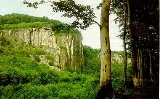
Although the PLA's territory is compact, it is made of two different landscapes. Vtáčnik, in the north is a range of volcanic origin and is part of the Slovenské stredohorieSlovenské stredohorie
Slovenské stredohorie is a group of mountain ranges in southern central Slovakia. Approximately in the center of the mountains lies the city of Zvolen.Slovenské stredohorie is a part of the Inner Western Carpathians...
mountains. Beech and fir trees dominate in the area. The highest mountain is Vtáčnik at . Tribeč, in the south, is a crystalline mountain range built on granitoide rocks, limestone and dolomite. Beech, hornbeam and in higher locations oak forests are covering the area. The highest mountain is Veľký Tribeč at .