
Pierce, Colorado
Encyclopedia
Pierce is a Statutory Town in Weld County
, Colorado
, United States
. The population was 884 at the 2000 census
. The town is a rural agricultural
community located on the Colorado Eastern Plains
along U.S. Highway 85 north of Greeley
.
, in anticipation of the construction of an extension of the Union Pacific line southward into Colorado. The following year in 1870 it became a watering stop for steam locomotive
s on the newly built Denver Pacific Railroad . A box car was used as the first town post office, depot, and telegraph
office. A depot was constructed in 1905 and demolished in 1963. As a railroad stop, it became a local shipping point for cattle
, sheep, potato
es, beans, and sugar beet
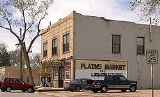
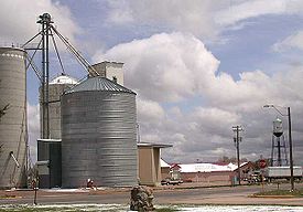
s. The town underwent a decline in population (from 1,000 in 1976) and its economic base during the latter 20th century with the construction of highways that allowed more direct shipping of agricultural products. The town today consists of a small grid of gravel streets, with one paved thoroughfare (Main Street) west of U.S. Highway 85. The principal businesses in town include a grain elevator
, as well as a grocery store, tavern, and other businesses along Main Street. The town also has a school, a volunteer fire station, a church, and a town park.
According to the United States Census Bureau
, the town has a total area of 0.7 square miles (1.8 km²), all of it land.
of 2000, there were 884 people, 312 households, and 249 families residing in the town. The population density
was 1,198.7 people per square mile (461.2/km²). There were 318 housing units at an average density of 431.2 per square mile (165.9/km²). The racial makeup of the town was 86.99% White, 0.45% Native American, 0.79% Asian, 0.11% Pacific Islander, 9.73% from other races
, and 1.92% from two or more races. Hispanic or Latino of any race were 20.48% of the population.
There were 312 households out of which 39.4% had children under the age of 18 living with them, 62.8% were married couples
living together, 11.5% had a female householder with no husband present, and 19.9% were non-families. 17.0% of all households were made up of individuals and 4.8% had someone living alone who was 65 years of age or older. The average household size was 2.83 and the average family size was 3.15.
In the town the population was spread out with 30.4% under the age of 18, 7.7% from 18 to 24, 31.9% from 25 to 44, 19.0% from 45 to 64, and 11.0% who were 65 years of age or older. The median age was 35 years. For every 100 females there were 102.3 males. For every 100 females age 18 and over, there were 99.7 males.
The median income for a household in the town was $36,944, and the median income for a family was $44,265. Males had a median income of $33,611 versus $22,174 for females. The per capita income
for the town was $17,412. About 4.6% of families and 6.9% of the population were below the poverty line, including 9.0% of those under age 18 and 10.4% of those age 65 or over.
Weld County, Colorado
As of the census of 2000, there were 180,936 people, 63,247 households, and 45,221 families residing in the county. The population density was 45 people per square mile . There were 66,194 housing units at an average density of 17 per square mile...
, Colorado
Colorado
Colorado is a U.S. state that encompasses much of the Rocky Mountains as well as the northeastern portion of the Colorado Plateau and the western edge of the Great Plains...
, United States
United States
The United States of America is a federal constitutional republic comprising fifty states and a federal district...
. The population was 884 at the 2000 census
United States Census, 2000
The Twenty-second United States Census, known as Census 2000 and conducted by the Census Bureau, determined the resident population of the United States on April 1, 2000, to be 281,421,906, an increase of 13.2% over the 248,709,873 persons enumerated during the 1990 Census...
. The town is a rural agricultural
Agriculture
Agriculture is the cultivation of animals, plants, fungi and other life forms for food, fiber, and other products used to sustain life. Agriculture was the key implement in the rise of sedentary human civilization, whereby farming of domesticated species created food surpluses that nurtured the...
community located on the Colorado Eastern Plains
Colorado Eastern Plains
The Eastern Plains of Colorado refers to a region of the U.S. state of Colorado east of the Rocky Mountains and east of the population centers of the Front Range.-Geography:...
along U.S. Highway 85 north of Greeley
Greeley, Colorado
The City of Greeley is a Home Rule Municipality that is the county seat and the most populous city of Weld County, Colorado, United States. Greeley is located in the region known as Northern Colorado. Greeley is situated north-northeast of the Colorado State Capitol in Denver. According to the...
.
History
Pierce It was founded in 1869 and incorporated in 1918. It was named in honor of John Pierce, then president of the Union Pacific RailroadUnion Pacific Railroad
The Union Pacific Railroad , headquartered in Omaha, Nebraska, is the largest railroad network in the United States. James R. Young is president, CEO and Chairman....
, in anticipation of the construction of an extension of the Union Pacific line southward into Colorado. The following year in 1870 it became a watering stop for steam locomotive
Steam locomotive
A steam locomotive is a railway locomotive that produces its power through a steam engine. These locomotives are fueled by burning some combustible material, usually coal, wood or oil, to produce steam in a boiler, which drives the steam engine...
s on the newly built Denver Pacific Railroad . A box car was used as the first town post office, depot, and telegraph
Telegraphy
Telegraphy is the long-distance transmission of messages via some form of signalling technology. Telegraphy requires messages to be converted to a code which is known to both sender and receiver...
office. A depot was constructed in 1905 and demolished in 1963. As a railroad stop, it became a local shipping point for cattle
Cattle
Cattle are the most common type of large domesticated ungulates. They are a prominent modern member of the subfamily Bovinae, are the most widespread species of the genus Bos, and are most commonly classified collectively as Bos primigenius...
, sheep, potato
Potato
The potato is a starchy, tuberous crop from the perennial Solanum tuberosum of the Solanaceae family . The word potato may refer to the plant itself as well as the edible tuber. In the region of the Andes, there are some other closely related cultivated potato species...
es, beans, and sugar beet
Sugar beet
Sugar beet, a cultivated plant of Beta vulgaris, is a plant whose tuber contains a high concentration of sucrose. It is grown commercially for sugar production. Sugar beets and other B...
s. The town underwent a decline in population (from 1,000 in 1976) and its economic base during the latter 20th century with the construction of highways that allowed more direct shipping of agricultural products. The town today consists of a small grid of gravel streets, with one paved thoroughfare (Main Street) west of U.S. Highway 85. The principal businesses in town include a grain elevator
Grain elevator
A grain elevator is a tower containing a bucket elevator, which scoops up, elevates, and then uses gravity to deposit grain in a silo or other storage facility...
, as well as a grocery store, tavern, and other businesses along Main Street. The town also has a school, a volunteer fire station, a church, and a town park.
Geography
Pierce is located at 40°38′6"N 104°45′16"W (40.635134, -104.754574).According to the United States Census Bureau
United States Census Bureau
The United States Census Bureau is the government agency that is responsible for the United States Census. It also gathers other national demographic and economic data...
, the town has a total area of 0.7 square miles (1.8 km²), all of it land.
Demographics
As of the censusCensus
A census is the procedure of systematically acquiring and recording information about the members of a given population. It is a regularly occurring and official count of a particular population. The term is used mostly in connection with national population and housing censuses; other common...
of 2000, there were 884 people, 312 households, and 249 families residing in the town. The population density
Population density
Population density is a measurement of population per unit area or unit volume. It is frequently applied to living organisms, and particularly to humans...
was 1,198.7 people per square mile (461.2/km²). There were 318 housing units at an average density of 431.2 per square mile (165.9/km²). The racial makeup of the town was 86.99% White, 0.45% Native American, 0.79% Asian, 0.11% Pacific Islander, 9.73% from other races
Race (United States Census)
Race and ethnicity in the United States Census, as defined by the Federal Office of Management and Budget and the United States Census Bureau, are self-identification data items in which residents choose the race or races with which they most closely identify, and indicate whether or not they are...
, and 1.92% from two or more races. Hispanic or Latino of any race were 20.48% of the population.
There were 312 households out of which 39.4% had children under the age of 18 living with them, 62.8% were married couples
Marriage
Marriage is a social union or legal contract between people that creates kinship. It is an institution in which interpersonal relationships, usually intimate and sexual, are acknowledged in a variety of ways, depending on the culture or subculture in which it is found...
living together, 11.5% had a female householder with no husband present, and 19.9% were non-families. 17.0% of all households were made up of individuals and 4.8% had someone living alone who was 65 years of age or older. The average household size was 2.83 and the average family size was 3.15.
In the town the population was spread out with 30.4% under the age of 18, 7.7% from 18 to 24, 31.9% from 25 to 44, 19.0% from 45 to 64, and 11.0% who were 65 years of age or older. The median age was 35 years. For every 100 females there were 102.3 males. For every 100 females age 18 and over, there were 99.7 males.
The median income for a household in the town was $36,944, and the median income for a family was $44,265. Males had a median income of $33,611 versus $22,174 for females. The per capita income
Per capita income
Per capita income or income per person is a measure of mean income within an economic aggregate, such as a country or city. It is calculated by taking a measure of all sources of income in the aggregate and dividing it by the total population...
for the town was $17,412. About 4.6% of families and 6.9% of the population were below the poverty line, including 9.0% of those under age 18 and 10.4% of those age 65 or over.
In popular culture
- The opening scene of the 2000 science fiction film Titan A.E.Titan A.E.Titan A.E. is an American animated post-apocalyptic science fiction film directed by Don Bluth and Gary Goldman released in 2000. The title refers to the spacecraft that is central to the plot, with A.E. meaning "After Earth."...
takes place in Pierce, Colorado.
See also
- Colorado municipalitiesColorado municipalitiesThe U.S. state of Colorado currently has 271 active incorporated municipalities, including 196 towns, 73 cities, and two consolidated city and county governments.-Municipal government:...
- Denver-Aurora-Boulder Combined Statistical AreaDenver-Aurora-Boulder Combined Statistical Areathumb|300px|Map of the 12-county Denver-Aurora-Boulder Combined Statistical AreaThe Denver-Aurora-Boulder, CO Combined Statistical Area is a United States Census Bureau defined Combined Statistical Area located in the Denver region of the state of Colorado...
- Front Range Urban CorridorFront Range Urban CorridorThe Front Range Urban Corridor is an oblong region of urban population located along the eastern face of the Southern Rocky Mountains in the U.S. states of Colorado and Wyoming. The corridor derives its name from the Front Range, the mountain range that defines the west central boundary of the...
- Greeley Metropolitan Statistical Area
- State of Colorado
- Weld County, ColoradoWeld County, ColoradoAs of the census of 2000, there were 180,936 people, 63,247 households, and 45,221 families residing in the county. The population density was 45 people per square mile . There were 66,194 housing units at an average density of 17 per square mile...