
Petrel, North Dakota
Encyclopedia
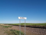
Petrel is a ghost town
in Adams County
, North Dakota
, United States
. It is located just across the border with South Dakota
, between Lemmon, South Dakota
, in Perkins County
and Haynes, North Dakota
. Petrel is a former railroad townsite and siding on the Milwaukee Railroad
. The town was named for the long-winged pigeons seen in the area.
 Petrel was established as a townsite along the Chicago, Milwaukee, St. Paul and Pacific Railroad
in Gilstrap Township
. A post office was established in the town on October 29, 1908 when the post office for the neighboring area of Thebes was moved to the new townsite and assumed the new name. The Petrel post office closed September 30, 1939, and mail service was transferred to Lemmon, South Dakota
. As a result the town and the surrounding area share the Lemmon ZIP Code
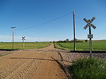
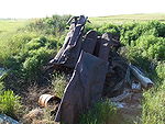
of 57638, even though they are in North Dakota. Little remains of the physical town today, other than a few deteriorating building foundations and other equipment.
BNSF Railway
operates the railroad today. Petrel is located at mile marker 909.7.
The city of Rhame
in neighboring Bowman County
was originally named Petrel when it was founded in 1908, but the name was soon changed to avoid confusion.
-South Dakota
border. It is 6 miles (9.7 km) from Lemmon
and 21 miles (33.8 km) from Hettinger
, the county seat of Adams County, North Dakota
.
 Petrel had approximately 100 people living there in the mid to late 1910s. A population of roughly 65 people was recorded in 1960. Today, it is a ghost town
, with much of the population spread throughout the countryside. Today, the United States Census Bureau
does not track specific population numbers for the community, but the surrounding township had a population of 28 as of the 2000 Census
.
Ghost town
A ghost town is an abandoned town or city. A town often becomes a ghost town because the economic activity that supported it has failed, or due to natural or human-caused disasters such as floods, government actions, uncontrolled lawlessness, war, or nuclear disasters...
in Adams County
Adams County, North Dakota
As of the census of 2000, there were 2,593 people, 1,121 households, and 725 families residing in the county. The population density was 2.6 people per square mile . There were 1,416 housing units at an average density of 1.4 per square mile...
, North Dakota
North Dakota
North Dakota is a state located in the Midwestern region of the United States of America, along the Canadian border. The state is bordered by Canada to the north, Minnesota to the east, South Dakota to the south and Montana to the west. North Dakota is the 19th-largest state by area in the U.S....
, United States
United States
The United States of America is a federal constitutional republic comprising fifty states and a federal district...
. It is located just across the border with South Dakota
South Dakota
South Dakota is a state located in the Midwestern region of the United States. It is named after the Lakota and Dakota Sioux American Indian tribes. Once a part of Dakota Territory, South Dakota became a state on November 2, 1889. The state has an area of and an estimated population of just over...
, between Lemmon, South Dakota
Lemmon, South Dakota
Lemmon is a city in Perkins County, South Dakota, United States. The population was 1,227 at the 2010 census.-Geography:Lemmon is located at ....
, in Perkins County
Perkins County, South Dakota
As of the census of 2000, there were 3,363 people, 1,429 households, and 937 families residing in the county. The population density was 1.2 people per square mile . There were 1,854 housing units at an average density of 0.6 per square mile...
and Haynes, North Dakota
Haynes, North Dakota
As of the census of 2000, there were 19 people, 10 households, and 5 families residing in the city. The population density was 143.4 people per square mile . There were 15 housing units at an average density of 113.2 per square mile...
. Petrel is a former railroad townsite and siding on the Milwaukee Railroad
Chicago, Milwaukee, St. Paul and Pacific Railroad
The Milwaukee Road, officially the Chicago, Milwaukee, St. Paul and Pacific Railroad , was a Class I railroad that operated in the Midwest and Northwest of the United States from 1847 until its merger into the Soo Line Railroad on January 1, 1986. The company went through several official names...
. The town was named for the long-winged pigeons seen in the area.
History
Chicago, Milwaukee, St. Paul and Pacific Railroad
The Milwaukee Road, officially the Chicago, Milwaukee, St. Paul and Pacific Railroad , was a Class I railroad that operated in the Midwest and Northwest of the United States from 1847 until its merger into the Soo Line Railroad on January 1, 1986. The company went through several official names...
in Gilstrap Township
Gilstrap Township, Adams County, North Dakota
Gilstrap Township is a township in Adams County, North Dakota, USA. As of the 2000 census, its population was 28.Gilstrap Township has one unincorporated community, Petrel, North Dakota.-References:...
. A post office was established in the town on October 29, 1908 when the post office for the neighboring area of Thebes was moved to the new townsite and assumed the new name. The Petrel post office closed September 30, 1939, and mail service was transferred to Lemmon, South Dakota
Lemmon, South Dakota
Lemmon is a city in Perkins County, South Dakota, United States. The population was 1,227 at the 2010 census.-Geography:Lemmon is located at ....
. As a result the town and the surrounding area share the Lemmon ZIP Code
ZIP Code
ZIP codes are a system of postal codes used by the United States Postal Service since 1963. The term ZIP, an acronym for Zone Improvement Plan, is properly written in capital letters and was chosen to suggest that the mail travels more efficiently, and therefore more quickly, when senders use the...
of 57638, even though they are in North Dakota. Little remains of the physical town today, other than a few deteriorating building foundations and other equipment.
BNSF Railway
BNSF Railway
The BNSF Railway is a wholly owned subsidiary of Berkshire Hathaway Inc., and is headquartered in Fort Worth, Texas. It is one of seven North American Class I railroads and the second largest freight railroad network in North America, second only to the Union Pacific Railroad, its primary...
operates the railroad today. Petrel is located at mile marker 909.7.
The city of Rhame
Rhame, North Dakota
Rhame is a city in Bowman County, North Dakota in the United States. The population was 169 at the 2010 census. Rhame was founded in 1908.-History:...
in neighboring Bowman County
Bowman County, North Dakota
-Major highways:* U.S. Highway 12* U.S. Highway 85* North Dakota Highway 67-Demographics:As of the census of 2000, there were 3,242 people, 1,358 households, and 890 families residing in the county. The population density was 3 people per square mile . There were 1,596 housing units at an average...
was originally named Petrel when it was founded in 1908, but the name was soon changed to avoid confusion.
Geography
Petrel is located roughly 1 miles (1.6 km) north of the North DakotaNorth Dakota
North Dakota is a state located in the Midwestern region of the United States of America, along the Canadian border. The state is bordered by Canada to the north, Minnesota to the east, South Dakota to the south and Montana to the west. North Dakota is the 19th-largest state by area in the U.S....
-South Dakota
South Dakota
South Dakota is a state located in the Midwestern region of the United States. It is named after the Lakota and Dakota Sioux American Indian tribes. Once a part of Dakota Territory, South Dakota became a state on November 2, 1889. The state has an area of and an estimated population of just over...
border. It is 6 miles (9.7 km) from Lemmon
Lemmon, South Dakota
Lemmon is a city in Perkins County, South Dakota, United States. The population was 1,227 at the 2010 census.-Geography:Lemmon is located at ....
and 21 miles (33.8 km) from Hettinger
Hettinger, North Dakota
As of the census of 2000, there were 1,307 people, 584 households, and 345 families residing in the city. The population density was 1,556.6 people per square mile . There were 720 housing units at an average density of 857.5 per square mile...
, the county seat of Adams County, North Dakota
Adams County, North Dakota
As of the census of 2000, there were 2,593 people, 1,121 households, and 725 families residing in the county. The population density was 2.6 people per square mile . There were 1,416 housing units at an average density of 1.4 per square mile...
.
Demographics
Ghost town
A ghost town is an abandoned town or city. A town often becomes a ghost town because the economic activity that supported it has failed, or due to natural or human-caused disasters such as floods, government actions, uncontrolled lawlessness, war, or nuclear disasters...
, with much of the population spread throughout the countryside. Today, the United States Census Bureau
United States Census Bureau
The United States Census Bureau is the government agency that is responsible for the United States Census. It also gathers other national demographic and economic data...
does not track specific population numbers for the community, but the surrounding township had a population of 28 as of the 2000 Census
United States Census, 2000
The Twenty-second United States Census, known as Census 2000 and conducted by the Census Bureau, determined the resident population of the United States on April 1, 2000, to be 281,421,906, an increase of 13.2% over the 248,709,873 persons enumerated during the 1990 Census...
.
Notable natives
- Henry J. StingerHenry J. StingerHenry J. Stinger was a Republican member of the North Dakota House of Representatives from 1913 to 1918. He lived in Spring Butte Township.-Personal life:...
, RepublicanRepublican Party (United States)The Republican Party is one of the two major contemporary political parties in the United States, along with the Democratic Party. Founded by anti-slavery expansion activists in 1854, it is often called the GOP . The party's platform generally reflects American conservatism in the U.S...
member of the North Dakota House of RepresentativesNorth Dakota House of RepresentativesThe North Dakota House of Representatives is the lower house of the North Dakota Legislative Assembly and is larger than the North Dakota Senate....
(1913-1918) - Martin HersrudMartin HersrudMartin Hersrud was a Republican member of the North Dakota House of Representatives from 1911 to 1912. It was his first and only term in the House. He represented Adams County in the 49th Legislative District.-Personal life:...
, RepublicanRepublican Party (United States)The Republican Party is one of the two major contemporary political parties in the United States, along with the Democratic Party. Founded by anti-slavery expansion activists in 1854, it is often called the GOP . The party's platform generally reflects American conservatism in the U.S...
member of the North Dakota House of RepresentativesNorth Dakota House of RepresentativesThe North Dakota House of Representatives is the lower house of the North Dakota Legislative Assembly and is larger than the North Dakota Senate....
(1911-1912)