
Pembrokeshire Coast Path
Encyclopedia
The Pembrokeshire Coast Path is a National Trail in southwest Wales
. It was established in 1970, and is 186 miles (300km) long, mostly at cliff-top level, with 35,000 feet (11,000 m) of ascent and descent. The northern end is at Poppit Sands
, near St. Dogmaels
, Ceredigion
, the southern end is at Amroth
, Pembrokeshire
.
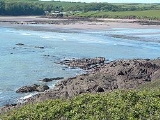
Walkers on the path have access to the range of sandy beaches along the Pembrokeshire
coast. There are a handful of seaside towns along the path, and a number of small hotels and guest houses that are generally family-run. There are also cottages for hire, built in traditional styles. The backpacker will find enough shops and campsites along the way, but may need to carry food and water for two days in one or two places.
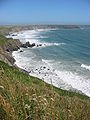 The walking is not strenuous, but there are inclines and narrow sections of the path, and many stiles, so some effort and fitness is required. In fact, management of the path has reduced the difficulty level, by creating more stepped ascents and descents; however, the edges of the path can be dangerous, due to the unstable cliff tops, so walkers are warned never to wander from the path towards the cliff edge. Having said that, a small amount of common sense will allow walkers to get closer to the cliff tops where the path moves inland, without too much risk. There are two low-tide crossings, at Dale
and Sandy Haven, requiring lengthy detours if not timed suitably.
In addition to the scenery, a key attraction of the coastal path is the birdlife. The path has a huge variety of European seabird
s that are supported by uninhabited offshore islands that act as bird sanctuaries such as Skomer
, Skokholm
and Ramsey Island
.
The Pembrokeshire Coast Path National Trail twists and turns its way through 186 miles of the most breathtaking coastal scenery in Britain.
From St Dogmaels in the north to Amroth in the south, the trail covers almost every kind of maritime landscape from rugged cliff tops and sheltered coves to wide-open beaches and winding estuaries.
Lying almost entirely within the Pembrokeshire Coast National Park —Britain’s only coastal national park – the trail displays an array of coastal flowers and bird life, as well as evidence of human activity from Neolithic times to the present.
In its entirety the Coast Path represents a formidable physical challenge - its 35,000 feet of ascent and descent is said to be equivalent to climbing Everest — yet it can also be enjoyed in shorter sections, accessible to people of all ages and abilities, with the small coastal villages strung out along its length offering welcome breaks and added enjoyment.
On this remote section the Pembrokeshire Coastal Path National Trail starts as it means to go on, quickly taking you up onto seaside clifftops after a brief few miles on the road initially. There is some steep climbing to do on much of this section, but you are rewarded with great tremendous views of the local geology, plants and wildlife. There are various paths taking you down to the shore, but beware, as some of them are steep and slippy.
As you near Newport, a section of the path is prone to high tide flooding in springtime. These waters generally take an hour or two to recede and official advice is to take the time to relax and take in the surroundings for that time, rather than find an alternative route.
There are the remnants of Neolithic and Iron Age constructions to be seen in addition to the numerous natural features.
Wales
Wales is a country that is part of the United Kingdom and the island of Great Britain, bordered by England to its east and the Atlantic Ocean and Irish Sea to its west. It has a population of three million, and a total area of 20,779 km²...
. It was established in 1970, and is 186 miles (300km) long, mostly at cliff-top level, with 35,000 feet (11,000 m) of ascent and descent. The northern end is at Poppit Sands
Poppit Sands
Poppit Sands is primarily known as a sandy Blue Flag beach in northern Pembrokeshire, Wales It lies on the estuary of the River Teifi near Cardigan, and is adjacent to St. Dogmael's beach, at its eastern estuary end. The nearest village is St Dogmaels, and it offers views across the estuary and...
, near St. Dogmaels
St. Dogmaels
St Dogmaels is a village and community in Pembrokeshire, Wales, on the estuary of the River Teifi, a mile downstream from the town of Cardigan in neighbouring Ceredigion....
, Ceredigion
Ceredigion
Ceredigion is a county and former kingdom in mid-west Wales. As Cardiganshire , it was created in 1282, and was reconstituted as a county under that name in 1996, reverting to Ceredigion a day later...
, the southern end is at Amroth
Amroth, Pembrokeshire
Amroth is a holiday resort village, east of Tenby, Pembrokeshire in West Wales, noted for long sandy beach.-History:The name is Welsh, and probably means "On Rhath".The beach stretches the whole length of the village...
, Pembrokeshire
Pembrokeshire
Pembrokeshire is a county in the south west of Wales. It borders Carmarthenshire to the east and Ceredigion to the north east. The county town is Haverfordwest where Pembrokeshire County Council is headquartered....
.
Walkers on the path have access to the range of sandy beaches along the Pembrokeshire
Pembrokeshire
Pembrokeshire is a county in the south west of Wales. It borders Carmarthenshire to the east and Ceredigion to the north east. The county town is Haverfordwest where Pembrokeshire County Council is headquartered....
coast. There are a handful of seaside towns along the path, and a number of small hotels and guest houses that are generally family-run. There are also cottages for hire, built in traditional styles. The backpacker will find enough shops and campsites along the way, but may need to carry food and water for two days in one or two places.
Dale, Pembrokeshire
Dale is a small village and community in Pembrokeshire, West Wales, located on the Dale Peninsula which forms the northern side of the entrance to Milford Haven estuary. The village has 205 inhabitants according to the 2001 census.-History:...
and Sandy Haven, requiring lengthy detours if not timed suitably.
In addition to the scenery, a key attraction of the coastal path is the birdlife. The path has a huge variety of European seabird
Seabird
Seabirds are birds that have adapted to life within the marine environment. While seabirds vary greatly in lifestyle, behaviour and physiology, they often exhibit striking convergent evolution, as the same environmental problems and feeding niches have resulted in similar adaptations...
s that are supported by uninhabited offshore islands that act as bird sanctuaries such as Skomer
Skomer
Skomer is a 2.92 km² island off the coast of southwest Wales, one of a chain lying within a kilometre off the Pembrokeshire coast and separated from the mainland by the treacherous waters of Jack Sound....
, Skokholm
Skokholm
Skokholm is an uninhabited island off the coast of south west Pembrokeshire in Wales, lying south of the neighbouring island of Skomer. The whole island is a Site of Special Scientific Interest as is Skomer. The surrounding waters are a marine reserve, all part of the Pembrokeshire Coast National...
and Ramsey Island
Ramsey Island
Ramsey Island is an island about 1 km off the coast of the St David's peninsula in Pembrokeshire on the northern side of St Brides Bay, in southwest Wales....
.
The Pembrokeshire Coast Path National Trail twists and turns its way through 186 miles of the most breathtaking coastal scenery in Britain.
From St Dogmaels in the north to Amroth in the south, the trail covers almost every kind of maritime landscape from rugged cliff tops and sheltered coves to wide-open beaches and winding estuaries.
Lying almost entirely within the Pembrokeshire Coast National Park —Britain’s only coastal national park – the trail displays an array of coastal flowers and bird life, as well as evidence of human activity from Neolithic times to the present.
In its entirety the Coast Path represents a formidable physical challenge - its 35,000 feet of ascent and descent is said to be equivalent to climbing Everest — yet it can also be enjoyed in shorter sections, accessible to people of all ages and abilities, with the small coastal villages strung out along its length offering welcome breaks and added enjoyment.
On this remote section the Pembrokeshire Coastal Path National Trail starts as it means to go on, quickly taking you up onto seaside clifftops after a brief few miles on the road initially. There is some steep climbing to do on much of this section, but you are rewarded with great tremendous views of the local geology, plants and wildlife. There are various paths taking you down to the shore, but beware, as some of them are steep and slippy.
As you near Newport, a section of the path is prone to high tide flooding in springtime. These waters generally take an hour or two to recede and official advice is to take the time to relax and take in the surroundings for that time, rather than find an alternative route.
There are the remnants of Neolithic and Iron Age constructions to be seen in addition to the numerous natural features.