
.gif)
Painted Rocks (Arizona)
Encyclopedia
Painted Rocks is a collection of hundreds of ancient petroglyphs in Maricopa County, Arizona
near the town of Theba
. It is listed on the National Register of Historic Places
. The petroglyphs are located within the Painted Rock Petroglyph Site which includes an improved campground
as well as an informative walking trail showcasing the petroglyphs. The site is operated and maintained by the United States
Bureau of Land Management
.
Painted Rocks is located along a number of important historical routes, including that of Juan Bautista de Anza
's expedition of 1775-1776; the route of the Mormon Battalion
; and the Butterfield Overland Mail
stagecoach
route. As a result, the site contains inscriptions made by travelers in these and other groups along with the petroglyphs.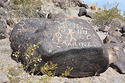 The site was listed on the National Register of Historic Places in 1977. Prior to 1989, the site existed as Painted Rocks State Park, and included camping facilities on the nearby Painted Rock Reservoir referred to as the "Lake Unit". When the state turned control of the park over to the BLM in 1989, the Lake Unit was closed due to concerns over pollutants in the Gila River
and is not maintained by the BLM.
in the Gila Bend Mountains
there are similar ancient petroglyphs with stick figures with long, wavy headdresses and solid circles in the middle of their bodies. These are not common in other parts of the American Southwest.
Maricopa County, Arizona
-2010:Whereas according to the 2010 U.S. Census Bureau:*73.0% White*5.0% Black*2.1% Native American*3.5% Asian*0.2% Native Hawaiian or Pacific Islander*3.5% Two or more races*12.7% Other races*29.6% Hispanic or Latino -2000:...
near the town of Theba
Theba, Arizona
Theba is a census-designated place in Maricopa County, Arizona, United States. Its elevation is 728 feet . Theba is located along Interstate 8 and is served by Exit 106....
. It is listed on the National Register of Historic Places
National Register of Historic Places
The National Register of Historic Places is the United States government's official list of districts, sites, buildings, structures, and objects deemed worthy of preservation...
. The petroglyphs are located within the Painted Rock Petroglyph Site which includes an improved campground
Camping
Camping is an outdoor recreational activity. The participants leave urban areas, their home region, or civilization and enjoy nature while spending one or several nights outdoors, usually at a campsite. Camping may involve the use of a tent, caravan, motorhome, cabin, a primitive structure, or no...
as well as an informative walking trail showcasing the petroglyphs. The site is operated and maintained by the United States
United States
The United States of America is a federal constitutional republic comprising fifty states and a federal district...
Bureau of Land Management
Bureau of Land Management
The Bureau of Land Management is an agency within the United States Department of the Interior which administers America's public lands, totaling approximately , or one-eighth of the landmass of the country. The BLM also manages of subsurface mineral estate underlying federal, state and private...
.
Painted Rocks is located along a number of important historical routes, including that of Juan Bautista de Anza
Juan Bautista de Anza
Juan Bautista de Anza Bezerra Nieto was a Novo-Spanish explorer and Governor of New Mexico for the Spanish Empire.-Early life:...
's expedition of 1775-1776; the route of the Mormon Battalion
Mormon Battalion
The Mormon Battalion was the only religiously based unit in United States military history, and it served from July 1846 to July 1847 during the Mexican-American War. The battalion was a volunteer unit of between 534 and 559 Latter-day Saints men led by Mormon company officers, commanded by regular...
; and the Butterfield Overland Mail
Butterfield Overland Mail
The Butterfield Overland Mail Trail was a stagecoach route in the United States, operating from 1857 to 1861. It was a conduit for the U.S. mail from two eastern termini, Memphis, Tennessee and St. Louis, Missouri, meeting Fort Smith, Arkansas, and continuing through Indian Territory, New Mexico,...
stagecoach
Stagecoach
A stagecoach is a type of covered wagon for passengers and goods, strongly sprung and drawn by four horses, usually four-in-hand. Widely used before the introduction of railway transport, it made regular trips between stages or stations, which were places of rest provided for stagecoach travelers...
route. As a result, the site contains inscriptions made by travelers in these and other groups along with the petroglyphs.
Gila River
The Gila River is a tributary of the Colorado River, 650 miles long, in the southwestern states of New Mexico and Arizona.-Description:...
and is not maintained by the BLM.
The petroglyphs
Fifteen miles up the Gila RiverGila River
The Gila River is a tributary of the Colorado River, 650 miles long, in the southwestern states of New Mexico and Arizona.-Description:...
in the Gila Bend Mountains
Gila Bend Mountains
The Gila Bend Mountains are a 35-mile long mountain range of the north-central Sonoran Desert southwest of Phoenix, Arizona and in southwest Maricopa County....
there are similar ancient petroglyphs with stick figures with long, wavy headdresses and solid circles in the middle of their bodies. These are not common in other parts of the American Southwest.