

Ottadal
Encyclopedia
Skjåk
Skjåk is a municipality in Oppland county, Norway. It is part of the traditional region of Gudbrandsdal. The administrative centre of the municipality is the village of Bismo...
, Lom
Lom, Norway
Lom is a municipality in Oppland county, Norway. It is part of the traditional region of Gudbrandsdal. The administrative centre of the municipality is the village of Fossbergom....
, Vågå
Vågå
Vågå is a municipality in Oppland county, Norway. It is part of the traditional region of Gudbrandsdal. The administrative centre of the municipality is the village of Vågåmo....
and Sel
Sel
Sel is a municipality in Oppland county, Norway. It is part of the traditional region of Gudbrandsdal. The administrative centre of the municipality is the town of Otta....
in the county
Counties of Norway
Norway is divided into 19 administrative regions, called counties . The counties form the primary first-level subdivisions of Norway and are further divided into 430 municipalities...
of Oppland
Oppland
is a county in Norway, bordering Sør-Trøndelag, Møre og Romsdal, Sogn og Fjordane, Buskerud, Akershus, Oslo and Hedmark. The county administration is in Lillehammer. Oppland is, together with Hedmark, one of the only two landlocked counties of Norway....
, Norway
Norway
Norway , officially the Kingdom of Norway, is a Nordic unitary constitutional monarchy whose territory comprises the western portion of the Scandinavian Peninsula, Jan Mayen, and the Arctic archipelago of Svalbard and Bouvet Island. Norway has a total area of and a population of about 4.9 million...
.
Ottadalen is one of the lateral valleys of Gudbrandsdalen. Others include Gausdal
Gausdal
Gausdal is a municipality in Oppland county, Norway. It is part of the traditional region of Gudbrandsdal. The administrative centre of the municipality is the village of Segalstad bru...
, Heidal
Heidal
Heidal is a valley and parish within Gudbrandsdalen valley, in the county of Oppland, Norway.-History:Heidal parish was separated from Vågå as a separate municipality of its own on January 1, 1908. It was merged with the municipality of Sel on January 1, 1965.Heidal is a side valley of Gudbrandsdalen...
, and Vinstradal
Vinstradal
Vinstradal valley is located in Sør-Trøndelag municipality, Oppland county, Norway.The Vinstra river flows into Gudbrandsdalslågen at Vinstra village. The valley of Vinstradal is a side valley to the valley of Drivdalen. Vinstradal is a narrow V-shaped valley with steep valley sides and with a...
. It lies on the northern edge of Jotunheimen National Park. Historically Ottadalen has been widely used as artery
Artery
Arteries are blood vessels that carry blood away from the heart. This blood is normally oxygenated, exceptions made for the pulmonary and umbilical arteries....
between western and eastern Norway through the Breidalen in Skjåk
Skjåk
Skjåk is a municipality in Oppland county, Norway. It is part of the traditional region of Gudbrandsdal. The administrative centre of the municipality is the village of Bismo...
to Stryn
Stryn
Stryn is a municipality in the county of Sogn og Fjordane, Norway. It is located in the traditional district of Nordfjord. The administrative center of the municipality is the village of Stryn which had a population of 2,177 in 2009. The municipality is located along the innermost part of the...
, Breidalskrysset to Stranda
Stranda
Stranda is a municipality in Møre og Romsdal county, Norway. It is part of the Sunnmøre region. The administrative centre of the municipality is the village of Stranda....
, the Jostedalsbreen
Jostedalsbreen
Jostedalsbreen is the largest glacier in continental Europe. It is situated in Sogn og Fjordane county in Western Norway. Jostedalsbreen lies in the municipalities of Luster, Balestrand, Jølster, and Stryn. The highest peak in the area is Lodalskåpa at a height of .Jostedalsbreen has a total area...
glacier to Jostedalen and Luster, and Sognefjellet
Sognefjellet
Sognefjellet is a mountain pass through which Jotunheimen which connects Lustrafjorden with Ottadalen. The pass is locate din in Luster and Lom, Norway. Sognefjellsvegen, part of County Road 55 runs through the pass....
to Sogn
Sogn
Sogn is a traditional district in Western Norway . It is located in the county of Sogn og Fjordane, surrounding the Sognefjord. Sogn consists of the municipalities of Aurland, Balestrand, Hyllestad, Høyanger, Gulen, Leikanger, Luster, Lærdal, Sogndal, Solund, Vik, and Årdal. The district covers ...
. There is also a road from Vågå, through Jotunheimen
Jotunheimen
Jotunheimen is a mountainous area of roughly 3,500 km² in Southern Norway and is part of the long range known as the Scandinavian Mountains. The 29 highest mountains in Norway are all in Jotunheimen, including the very highest - Galdhøpiggen...
to Fagernes
Fagernes
is the largest settlement in the valley of Valdres, Norway, with a population of 1,801. Fagernes is the administrative centre of the municipality of Nord-Aurdal.See video from the Fagernes Town : *...
.
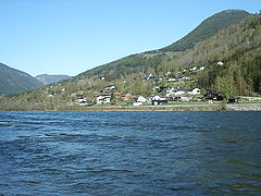
The Otta river flows through the Ottadal valley. The Otta river begins in Skjåk municipality and flows into lake Vågåvatn
Vågåvatn
The Vågåvatn lake is located in Lom and Vågå municipalities, Oppland county, Norway. The river Otta, which begins in Skjåk municipality, flows into lake Vågåvatn...
et. Exiting the Vågåvatnet at Vågåmo
Vågåmo
Vågåmo is the administrative centre of Vågå municipality, in Oppland county. Norway. Its population is 1,463. The village is located at the outlet of Lake Vågåvatn in the Otta valley...
, it continues its journey through the Ottadalen leaving Vågå municipality to meet the Gudbrandsdalslågen
Gudbrandsdalslågen
The Gudbrandsdalslågen river flows through the Gudbrandsdal of Norway.The Gudbrandsdalslågen begins in the lake Lesjaskogsvatnet , which lies in Lesja municipality in Oppland. Lesjavatn is the only lake in Norway which has two outlets; they flow into two of Norway’s more famous rivers...
at the town of Otta
Otta, Norway
is a town in the municipality of Sel in the county of Oppland in Norway. It has about 2,750 inhabitants. The Otta river joins the Gudbrandsdalslågen river at Otta. Next to Otta lies the massive Rondane, which became the first national park in Norway in 1962, and which has several mountains over...
in Sel
Sel
Sel is a municipality in Oppland county, Norway. It is part of the traditional region of Gudbrandsdal. The administrative centre of the municipality is the town of Otta....
municipality.
Reinheimen National Park
Reinheimen National Park
Reinheimen National Park was established in 2006. The park consists of a continuous protected mountain area. It is located in Møre og Romsdal and Oppland counties in Norway. The park includes parts of the municipalities of Lesja, Skjåk, Vågå, Lom, Norddal, and Rauma...
, which consists of much of the Tafjordfjella mountain range, includes the reindeer habitat in the northern part of the Ottadalen valley.
[edit] References
See also
- Otta sealOtta seal- History : Otta seal is a type of bituminous surface treatment that was developed by the Norwegian Road Research Laboratory . Its name is based off of the location in which it was created in, The Otta Valley...