
Ophir, Alaska
Encyclopedia
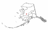
Ophir is an unincorporated area located in the Yukon-Koyukuk Census Area
in the U.S. state
of Alaska
.
It was named by miners after the wealthy land of Ophir
mentioned in the Old Testament. The area was the site of a gold rush in 1906. Ophir reached a peak population of 122 in 1910.
Ophir is now abandoned, but serves as a checkpoint in the Iditarod Trail Sled Dog Race. An airport with a single gravel runway exists at the village, built prior to 1949. It is currently in disuse and unmaintained.
There are a number of creeks near Ophir, all on the west bank of the Innoko, where gold placers were located starting about 1906. Yankee creek is the closest to the source of the river, then Ganes, Little and Spruce creek, all above Ophir creek. The original Iditarod trail ran above Ganes creek in the summer, down the Innoko valley in the winter; the current race trail goes through the old townsite, which was destroyed in a brush fire started by a camper in the 1970s, and is a rest stop.
Mining still goes on at Ganes and Little creeks, and probably at Ophir creek (2006). Further downriver, on the east side, there were mining operations at Folger, Cripple, Bear and Colorado creeks. Bear creek and Colorado still are actively mined (2006). Mining of tailings was underway at Cripple in 2010.
There were at least eight mining operations near Ophir in 1949, including two dredges, but $35 dollar gold winnowed them down to none by about 1955. There was sporadic mining after that, with new operations starting in the 1970s.
Ophir is located on the west bank of the Innoko River
in western Alaska, 48 km (29.8 mi) northwest of McGrath
, at the mouth of Ophir creek, which was mined for many years by Gust Utilla.
Yukon-Koyukuk Census Area, Alaska
Yukon-Koyukuk Census Area is a census area located in the state of Alaska, United States. As of the 2010 census, the population was 5,588. It is part of the unorganized borough and therefore has no borough seat...
in the U.S. state
U.S. state
A U.S. state is any one of the 50 federated states of the United States of America that share sovereignty with the federal government. Because of this shared sovereignty, an American is a citizen both of the federal entity and of his or her state of domicile. Four states use the official title of...
of Alaska
Alaska
Alaska is the largest state in the United States by area. It is situated in the northwest extremity of the North American continent, with Canada to the east, the Arctic Ocean to the north, and the Pacific Ocean to the west and south, with Russia further west across the Bering Strait...
.
It was named by miners after the wealthy land of Ophir
Ophir
Ophir is a port or region mentioned in the Bible, famous for its wealth. King Solomon is supposed to have received a cargo of gold, silver, sandalwood, precious stones, ivory, apes and peacocks from Ophir, every three years.- Citations :...
mentioned in the Old Testament. The area was the site of a gold rush in 1906. Ophir reached a peak population of 122 in 1910.
Ophir is now abandoned, but serves as a checkpoint in the Iditarod Trail Sled Dog Race. An airport with a single gravel runway exists at the village, built prior to 1949. It is currently in disuse and unmaintained.
There are a number of creeks near Ophir, all on the west bank of the Innoko, where gold placers were located starting about 1906. Yankee creek is the closest to the source of the river, then Ganes, Little and Spruce creek, all above Ophir creek. The original Iditarod trail ran above Ganes creek in the summer, down the Innoko valley in the winter; the current race trail goes through the old townsite, which was destroyed in a brush fire started by a camper in the 1970s, and is a rest stop.
Mining still goes on at Ganes and Little creeks, and probably at Ophir creek (2006). Further downriver, on the east side, there were mining operations at Folger, Cripple, Bear and Colorado creeks. Bear creek and Colorado still are actively mined (2006). Mining of tailings was underway at Cripple in 2010.
There were at least eight mining operations near Ophir in 1949, including two dredges, but $35 dollar gold winnowed them down to none by about 1955. There was sporadic mining after that, with new operations starting in the 1970s.
Geography
Ophir is located at 63°08′41"N 156°31′10"W .Ophir is located on the west bank of the Innoko River
Innoko River
The Innoko River is a river in western Alaska. It flows north from its origin south of Cloudy Mountain in the Kuskoswim Mountains and then flows southwest to its end at the Yukon River, across from Holy Cross, Alaska....
in western Alaska, 48 km (29.8 mi) northwest of McGrath
McGrath, Alaska
As of the census of 2000, there were 401 people, 145 households, and 99 families residing in the city. The population density was 8.2 people per square mile . There were 213 housing units at an average density of 4.4 per square mile...
, at the mouth of Ophir creek, which was mined for many years by Gust Utilla.