

Ohio State Route 579
Encyclopedia
State highway
State highway, state road or state route can refer to one of three related concepts, two of them related to a state or provincial government in a country that is divided into states or provinces :#A...
in northwestern Ohio
Ohio
Ohio is a Midwestern state in the United States. The 34th largest state by area in the U.S.,it is the 7th‑most populous with over 11.5 million residents, containing several major American cities and seven metropolitan areas with populations of 500,000 or more.The state's capital is Columbus...
, a U.S. state
U.S. state
A U.S. state is any one of the 50 federated states of the United States of America that share sovereignty with the federal government. Because of this shared sovereignty, an American is a citizen both of the federal entity and of his or her state of domicile. Four states use the official title of...
. The western terminus of State Route 579 is at State Route 51 just south of the city limits of Northwood
Northwood, Ohio
Northwood is a city in Wood County, Ohio, United States. The population was 5,471 at the 2000 census.-History:Northwood was originally Ross Township. It was the northernmost township in Wood County from its establishment on April 18, 1874 until December 1, 1962. Farms, gardens, orchards, and...
. Its eastern terminus is at a T-intersection with State Route 2 approximately 4 miles (6.4 km) to the east of Williston
Williston, Ohio
Williston is an unincorporated community in northern Allen Township, Ottawa County, Ohio, United States, located along State Route 579. It is located in the northwestern part of the state, near Toledo. Its ZIP code is 43468. Its population was 211 people, according to the 2000 Census...
.
Route description
State Route 579 travels through WoodWood County, Ohio
Wood County is a county located in the state of Ohio, United States. As of the 2010 census, the population was 125,488. Its county seat is Bowling Green. The county was named for Captain Eleazer D. Wood, the engineer for General William Henry Harrison's army, who built Fort Meigs in the War of 1812...
and Ottawa
Ottawa County, Ohio
Ottawa County is a county located in the state of Ohio, United States. As of the 2010 census, the population was 41,428. Its county seat is Port Clinton and is named either for the Ottawa Indians who lived there, or for an Indian word meaning "trader"....
Counties along its way. The highway is not a part of the National Highway System
National Highway System (United States)
The National Highway System is a network of strategic highways within the United States, including the Interstate Highway System and other roads serving major airports, ports, rail or truck terminals, railway stations, pipeline terminals and other strategic transport facilities.Individual states...
, a network of highways determined to be most important for the country's economony, mobility and defense.
Wood County
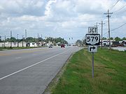
A signalized intersection with State Route 51 in Lake TownshipLake Township, Wood County, Ohio
Lake Township is one of the nineteen townships of Wood County, Ohio, United States. The 2000 census found 10,350 people in the township, 6,643 of whom lived in the unincorporated portions of the township.-Geography:...
just south of Northwood
Northwood, Ohio
Northwood is a city in Wood County, Ohio, United States. The population was 5,471 at the 2000 census.-History:Northwood was originally Ross Township. It was the northernmost township in Wood County from its establishment on April 18, 1874 until December 1, 1962. Farms, gardens, orchards, and...
marks the starting point of State Route 579. The route starts out in a northeasterly direction, but as it sweeps by the southeast corner of Woodville Mall, it turns due east, as it lines itself up with the boundary between Lake Township and the City of Northwood. State Route 579, which starts out briefly as a five-lane road, quickly narrows down to two lanes, and enters into a more rural setting. Passing by a mix of generally flat open space and subdivisions, State Route 579 intersects Bradner Road and Millbury Road on the way to its intersection with Fostoria Road, which marks the boundary between Wood and Ottawa Counties.
Ottawa County
Once it enters into Ottawa County's Allen TownshipAllen Township, Ottawa County, Ohio
Allen Township is one of the twelve townships of Ottawa County, Ohio, United States. The 2000 census found 3,591 people in the township, 3,297 of whom lived in the unincorporated portions of the township.-Geography:...
, State Route 579 continues on an easterly path, traversing numerous fields and passing by the occasional house. After Billman Road, State Route 579 abuts the north side of the Chippewa Golf Club. East of there, State Route 579 has split intersections with Reiman Road and Genoa-Clay Center Road. Past Genoa-Clay Center Road, State Route 579 enters into the unincorporated community of Williston
Williston, Ohio
Williston is an unincorporated community in northern Allen Township, Ottawa County, Ohio, United States, located along State Route 579. It is located in the northwestern part of the state, near Toledo. Its ZIP code is 43468. Its population was 211 people, according to the 2000 Census...
, where the state route is primarily a residential street. Following a split intersection with Martin-Williston Road and a railroad crossing, State Route 579 treks back into rural territory. The landscape remains both flat and consistent, with a mix of open fields and houses as State Route 579 has a split intersection with Opfer-Lentz Road, then goes on to meet Nissen Road.
Following the Nissen Road intersection, where State Route 579 enters into Benton Township
Benton Township, Ottawa County, Ohio
Benton Township is one of the twelve townships of Ottawa County, Ohio, United States. The 2000 census found 2,621 people in the township, 2,232 of whom lived in the unincorporated portions of the township.-Geography:...
, the highway has split intersections with Elliston-Trowbridge Road and Graytown Road. Just east of Graytown Road, State Route 579 bends slightly to the south, then back to the north, to come into the T-intersection with State Route 2 that serves as its eastern terminus.