
Ohio State Route 317
Encyclopedia
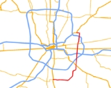
State Route 317 is a north–south state highway
in the central portion of the U.S. state
of Ohio
. Its southern terminus is at U.S. Route 23 approximately 9 miles (14.5 km) south of Downtown Columbus
and just outside of the city limits; its northern terminus is at U.S. Route 62 in Gahanna
. The route serves as a partial southeastern outbelt for the Columbus metropolitan area, passing through many commercial districts like Eastland Mall and many light industry areas near Rickenbacker International Airport
.
State highway
State highway, state road or state route can refer to one of three related concepts, two of them related to a state or provincial government in a country that is divided into states or provinces :#A...
in the central portion of the U.S. state
U.S. state
A U.S. state is any one of the 50 federated states of the United States of America that share sovereignty with the federal government. Because of this shared sovereignty, an American is a citizen both of the federal entity and of his or her state of domicile. Four states use the official title of...
of Ohio
Ohio
Ohio is a Midwestern state in the United States. The 34th largest state by area in the U.S.,it is the 7th‑most populous with over 11.5 million residents, containing several major American cities and seven metropolitan areas with populations of 500,000 or more.The state's capital is Columbus...
. Its southern terminus is at U.S. Route 23 approximately 9 miles (14.5 km) south of Downtown Columbus
Columbus, Ohio
Columbus is the capital of and the largest city in the U.S. state of Ohio. The broader metropolitan area encompasses several counties and is the third largest in Ohio behind those of Cleveland and Cincinnati. Columbus is the third largest city in the American Midwest, and the fifteenth largest city...
and just outside of the city limits; its northern terminus is at U.S. Route 62 in Gahanna
Gahanna, Ohio
As of the census of 2000, there were 32,636 people, 11,990 households, and 8,932 families residing in the city. The population density was 2,632.8 people per square mile . There were 12,390 housing units at an average density of 999.5 per square mile...
. The route serves as a partial southeastern outbelt for the Columbus metropolitan area, passing through many commercial districts like Eastland Mall and many light industry areas near Rickenbacker International Airport
Rickenbacker International Airport
Rickenbacker International Airport is a joint civil-military public airport located 10 miles south of the central business district of Columbus, near the village of Lockbourne in extreme southern Franklin County, Ohio, United States. The southern end of the airport extends into northern Pickaway...
.
History
- 1933 – Original route certified; originally routed from State Route 16 in WhitehallWhitehall, OhioAs of the census of 2000, there were 19,201 people, 8,343 households, and 4,930 families residing in the city. The population density was 3,681.9 people per square mile . There were 8,997 housing units at an average density of 1,725.2 per square mile...
to GahannaGahanna, OhioAs of the census of 2000, there were 32,636 people, 11,990 households, and 8,932 families residing in the city. The population density was 2,632.8 people per square mile . There were 12,390 housing units at an average density of 999.5 per square mile...
. - 1954 – From State Route 16 to 1 miles (1.6 km) south of Gahanna upgraded to four lanes.
- 1961 – Extended south to U.S. Route 33 along previously unnumbered road.
- 1972 – Extended south to GroveportGroveport, OhioGroveport is a City in Franklin County, Ohio, United States. The population was 5,363 at the 2010 census.Groveport was the hometown of John Solomon Rarey, a 19th century horse whisperer, and developer of the Rarey technique for rehabilitating horses...
along previously unnumbered road; from U.S. Route 33 to Interstate 70 upgraded to divided highwayDivided HighwayDivided Highway is a compilation album by American rock band The Doobie Brothers, released in 2003. . All tracks are taken from the albums Cycles and Brotherhood .-Track listing:...
. - 1974 – Extended west to U.S. Route 23 at Shadeville along the former alignment of State Route 665; Groveport to U.S. Route 33 upgraded to divided highway.