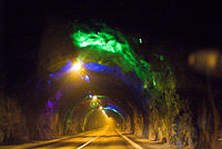
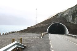
Norðoyatunnilin
Encyclopedia

Tunnel
A tunnel is an underground passageway, completely enclosed except for openings for egress, commonly at each end.A tunnel may be for foot or vehicular road traffic, for rail traffic, or for a canal. Some tunnels are aqueducts to supply water for consumption or for hydroelectric stations or are sewers...
of the Faroe Islands
Faroe Islands
The Faroe Islands are an island group situated between the Norwegian Sea and the North Atlantic Ocean, approximately halfway between Scotland and Iceland. The Faroe Islands are a self-governing territory within the Kingdom of Denmark, along with Denmark proper and Greenland...
. It connects the town of Leirvík
Leirvík
Leirvík is a town on the Faroe Islands and was an important regional ferry harbour at the east coast of the second largest island Eysturoy. Leirvík has 867 inhabitants...
on Eysturoy
Eysturoy
Eysturoy means East island and is the second-largest of the Faroe Islands in the North Atlantic, both in size and population. It is separated by a narrow sound from the main island of Streymoy. Eysturoy is extremely rugged, with some 66 separate mountain peaks, including Slættaratindur, the...
under the strait Leirvíksfjørður with the city of Klaksvík
Klaksvík
Klaksvík is the second largest town of the Faroe Islands.The town is located on Borðoy, which is one of the northernmost islands ....
on Borðoy
Borðoy
Borðoy is an island in the north-east of the Faroe Islands. There are eight settlements: Klaksvík , Norðoyri, Ánir, Árnafjørður, Strond, Norðtoftir, Depil and Norðdepil. There are also three abandoned settlements: Skálatoftir, Múli and Fossá, all in the north...
.
The Norðoyatunnilin is a road tunnel with two lanes and was finished in April 2006. The official opening was on April 19.