

Northwestern Cycleway
Encyclopedia
Auckland CBD
The Auckland CBD is the geographical and economic heart of the Auckland metropolitan area. Bounded by several major motorways and by the harbour coastline in the north, it is surrounded further out by mostly suburban areas...
in Auckland City
Auckland City
Auckland City was the city and local authority covering the Auckland isthmus and most of the islands of the Hauraki Gulf, in the North Island of New Zealand. On 1 November 2010 it was amalgamated into the wider Auckland Region under the authority of the new Auckland Council...
with Henderson
Henderson, New Zealand
Henderson is a major suburb of Auckland, in the North Island of New Zealand. It is located 13 kilometres to the west of Auckland city centre, and two kilometres to the west of the Whau River, a southwestern arm of the Waitemata Harbour.-Description:...
, Waitakere City in New Zealand
New Zealand
New Zealand is an island country in the south-western Pacific Ocean comprising two main landmasses and numerous smaller islands. The country is situated some east of Australia across the Tasman Sea, and roughly south of the Pacific island nations of New Caledonia, Fiji, and Tonga...
. For most of its length, it runs alongside the Northwestern Motorway (State Highway 16).
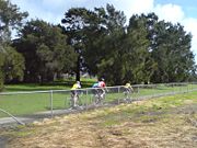
A cyclist count study for the Auckland Regional Transport Authority found that at the Great North Road section of the cycleway, the average daily number of users in 2008 was 532, a gain of 59% compared to the year before. In 2010, this success trend continued, with an increase of 70% over the 2007 levels to over 600 cyclists.
History
The original path was built by Waitakere City Council and Auckland City CouncilAuckland City Council
Auckland City Council was the local government authority representing Auckland City, New Zealand, and was amalgamated into the Auckland Council on 1 November 2010. It was an elected body representing the 404,658 residents of the city...
on land leased from Transit New Zealand
Transit New Zealand
Transit New Zealand was, from 1989 to 2008, the New Zealand Crown entity responsible for operating and planning the New Zealand State Highway network...
. It originally only connected from Te Atatu
Te Atatu
Te Atatu is the name of two suburbs in western Auckland, New Zealand: Te Atatu Peninsula and Te Atatu South. They are located next to each other some 10 kilometres to the west of the Auckland city centre....
to Waterview
Waterview, New Zealand
Waterview is a suburb of Auckland City, located along the western edge of central part of Auckland's isthmus. The geographical boundaries of Waterview are Oakley Creek in the east, Heron Park in the south, the Waitemata Harbour in the West, and the SH16 motorway and the Oakley Creek inlet in the...
, before being extended in the early 2000s a further 5 km east towards the city, with a new overbridge over Great North Road, completed in 2004, connecting these two original sections.
Kingsland upgrade
In November 2009, the NZTANew Zealand Transport Agency
The New Zealand Transport Agency is a New Zealand Crown entity tasked with promoting safe and functional transport by land, including the responsibility for driver and vehicle licensing and investigating rail accidents. It was created on 1 August 2008 by the Land Transport Management Amendment...
started construction on a missing section in the Kingsland
Kingsland, New Zealand
Kingsland is an Auckland City suburb in New Zealand. Kingsland is under the local governance of the Auckland City Council. According to the 2001 census, Kingsland has a population of 4005 people....
area, where cyclists to this point were forced to detour through a hilly residential area. The project was to cost $3m for approximately 1.2 km length, including several new planned side accesses (five side accesses were eventually constructed). Costs are relatively high due to the need to work around underground services, and to bridge Mountain View Road where it crosses under the motorway. After completion of the path itself, fences and noise wall
Noise barrier
A noise barrier is an exterior structure designed to protect sensitive land uses from noise pollution...
s will be replaced, and landscaping replanted.
The new path section was opened in April 2010, costing $3.7 (though much of this cost was in fact for new motorway noise walls for local residents) and was very well received by cyclists and the local cycle advocacy groups Cycle Action Auckland
Cycle Action Auckland
Cycle Action Auckland is a pro-cycling advocacy group in Auckland, New Zealand. The volunteer-driven group aims to improve infrastructure and conditions, as well as perceptions of cycling to encourage more "everyday people" to use bicycles, including for commuting and recreation...
.
Western & CBD extension
NZTA intends to improve and extend the path further northwest (from its current termination in HendersonHenderson, New Zealand
Henderson is a major suburb of Auckland, in the North Island of New Zealand. It is located 13 kilometres to the west of Auckland city centre, and two kilometres to the west of the Whau River, a southwestern arm of the Waitemata Harbour.-Description:...
up to Westgate in the coming years, as part of the planned Waterview Connection motorway upgrades. The works will include improving path widths and reducing occasional flooding of the cycleway on the low-lying causeway.
Separate from the Waterview upgrades, as part of the Lincoln Road Interchange works, NZTA has also announced that it will extend the cycleway a further 2 km further west, from its current end at Central Park Drive to Huruhuru Road Overbridge.
Together with Auckland City Council
Auckland City Council
Auckland City Council was the local government authority representing Auckland City, New Zealand, and was amalgamated into the Auckland Council on 1 November 2010. It was an elected body representing the 404,658 residents of the city...
, NZTA is also investigating extending the path eastwards towards the Auckland CBD
Auckland CBD
The Auckland CBD is the geographical and economic heart of the Auckland metropolitan area. Bounded by several major motorways and by the harbour coastline in the north, it is surrounded further out by mostly suburban areas...
, through Spaghetti Junction
Central Motorway Junction
The Central Motorway Junction or CMJ , is the intersection of New Zealand State Highways 1 and 16, just south of the central business district of Auckland, New Zealand...
, a project which is also being pushed by the Auckland Regional Council
Auckland Regional Council
The Auckland Regional Council was the regional council of the Auckland Region. Its predecessor the Auckland Regional Authority was formed in 1963 and became the ARC in 1989...
/ Auckland Regional Transport Authority. A preliminary alignment has been assessed for the cycleway to cross Spaghetti Junction
Central Motorway Junction
The Central Motorway Junction or CMJ , is the intersection of New Zealand State Highways 1 and 16, just south of the central business district of Auckland, New Zealand...
and then continue to the university area in the east of the CBD via Grafton Gully
Grafton Gully
Grafton Gully is a deep and very wide gully cutting northwards through the volcanic hills of the Auckland Volcanic Field in Auckland, New Zealand. It divides the CBD of the city from the suburbs of Grafton and Parnell in the east.Grafton Gully is crossed by Grafton Bridge near its south end...
. The extension is hoped to be in place as early as 2012, with later extensions to the waterfront not ruled out.