
New Water Mountains
Encyclopedia
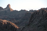
The New Water Mountains is a mountain range in southwestern Arizona. The range is on the northern border of the Kofa National Wildlife Refuge
as well as the northern Kofa Mountains
.
It is a northwest-southeast trending range, about 20 miles long. The southeast third of the range is in the Kofa Refuge, and the mountain range
merges northwesterly into the Plomosa Mountains
of southern La Paz
County. The central part of the range is the New Water Mountains Wilderness with a lengthy east-west border on the northern Kofa National Wildlife Refuge of about 12 miles. The highest point is Black Mesa at 3639 feet (1,109 m).
Three northerly routes access the mountain range; the central route accesses the Ramsey Mine and eventually the central dry wash on the north; other mines are in these mountains-(the Republic Mine), as well as some springs-(Dripping Spring); also Brintley Well on a fourth westerly access route. The closest community to the north side of the mountain range is Brenda
, Arizona east of Quartzsite
. Brenda is on US 60 4 mi northeast of Interstate 10
.
Kofa National Wildlife Refuge
The Kofa National Wildlife Refuge is located northeast of Yuma, Arizona, southeast of Quartzsite, Arizona, in the southwestern United States. The refuge, established in 1939 to protect Desert Bighorn Sheep, encompasses over of the Yuma Desert region of the Sonoran Desert...
as well as the northern Kofa Mountains
Kofa Mountains
The Kofa Mountains is the central mountain range comprising the Kofa National Wildlife Refuge, about 60 miles northeast of Yuma, Arizona in the southwestern part of the state...
.
It is a northwest-southeast trending range, about 20 miles long. The southeast third of the range is in the Kofa Refuge, and the mountain range
Mountain range
A mountain range is a single, large mass consisting of a succession of mountains or narrowly spaced mountain ridges, with or without peaks, closely related in position, direction, formation, and age; a component part of a mountain system or of a mountain chain...
merges northwesterly into the Plomosa Mountains
Plomosa Mountains
The Plomosa Mountains are a mountain range in La Paz County, Arizona, running generally south of Bouse, Arizona near the Arizona/California border. The maximum height of the range is 1791 feet ....
of southern La Paz
La Paz County, Arizona
La Paz County is a county in the western part of the U.S. state of Arizona. As of the 2010 census its population was 20,489. The county seat is Parker...
County. The central part of the range is the New Water Mountains Wilderness with a lengthy east-west border on the northern Kofa National Wildlife Refuge of about 12 miles. The highest point is Black Mesa at 3639 feet (1,109 m).
Three northerly routes access the mountain range; the central route accesses the Ramsey Mine and eventually the central dry wash on the north; other mines are in these mountains-(the Republic Mine), as well as some springs-(Dripping Spring); also Brintley Well on a fourth westerly access route. The closest community to the north side of the mountain range is Brenda
Brenda, Arizona
Brenda, Arizona is a small community in southwestern Arizona. It is located approximately 13 miles east of Quartzsite, , and 4 miles northeast on US 60 in Arizona....
, Arizona east of Quartzsite
Quartzsite, Arizona
Quartzsite is a town in La Paz County, Arizona, United States. According to Census Bureau estimates, the population of the town was 3,397 in 2006.Interstate 10 runs directly through Quartzsite. It is at the intersection of U.S...
. Brenda is on US 60 4 mi northeast of Interstate 10
Interstate 10 in Arizona
In the U.S. state of Arizona, Interstate 10, the major east–west Interstate Highway in the southern United States, runs east from California, enters Arizona and continues through Phoenix and Tucson and exits at the border with New Mexico.-Route description:...
.