
Nevada State Route 375
Encyclopedia
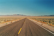
State Route 375 is a state highway
in south-central Nevada
in the United States
. The highway stretches 98 miles (157.7 km) from State Route 318
at Crystal Springs
northwest to U.S. Route 6 (US 6) at Warm Springs
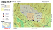
. The route travels through mostly unoccupied desert terrain, with much of its alignment paralleling the northern edges of the Nellis Air Force Range. The road originally traversed through what is now the northern reaches of the air force range in the 1930s, when it was previously designated State Route 25A and later part of State Route 25.
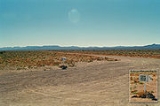
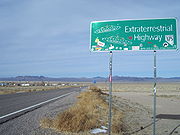
The top-secret Area 51
government base is near SR 375 and many travelers have reported UFO observations and other strange alien activity along this road. Such stories prompted the state to officially designate the route as the Extraterrestrial Highway in 1996. The small town of Rachel
, located near the center of the highway, caters to tourists and UFO seekers with alien-themed businesses. Although the area receives some tourism due to alleged extraterrestrial activity, SR 375 remains a lightly traveled route.
, a ghost town
in the northern end of the Pahranagat Valley
in the center of Lincoln County
. The site, which is little more than the junction and a few trees, functions as a rest area. From Crystal Springs, the highway curves southwest to pass between the Pahrangat
and Golden Gate Range
s to ascend 5592 feet (1,704.4 m) Hancock Summit.
Descending the summit, SR 375 nears the border of the Nellis Air Force Range. As the highway heads northwest through Tikaboo Valley, it meets Mail Box Road. Marked by a single postal drop known as the "black mailbox", the dirt access road leads to the restricted lands surrounding Area 51
. The mailbox, which is no longer black, is commonly used as a gathering place for UFO seekers, and two to three UFO sightings per week allegedly occur in the area. SR 375 continues heading northwest from the mailbox, climbing in elevation again to reach the top of Coyote Summit at 5591 feet (1,704.1 m).
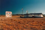
 West of the summit, the Extraterrestrial Highway descends into the Sand Spring Valley and the community of Rachel becomes visible. The small town of about 100 residents is little more than homes and a few businesses. The Little A'Le'Inn is the focal point of the town, providing a small motel, an alien-themed restaurant/bar, and extraterrestrial souvenirs. The civilian-run Area 51 Research Center, based out of a yellow house trailer and documenting paranormal activity in the area, closed in 2001.
Leaving Rachel, SR 375 continues northwest to enter Nye County
. The route climbs out of Sand Spring Valley and heads over the 5935 feet (1,809 m) Queen City Summit, the highest point on the highway. After passing the summit, the route descends into the southern end of Railroad Valley
, curving nearly due north for several miles as it follows the base of Reveille Range
. As the mountains subside, the road turns westward again to head to its northern terminus at the junction of US 6 at Warm Springs.
An unimproved road approximating the present alignment of State Route 375 came into existence by 1932. This route, christened State Route 25A, connected Crystal Springs to State Route 4 (now US 6) just east of Tonopah
. By 1933, SR 25A had been renumbered to become a new western segment of State Route 25. The route underwent periodic realignments over the next few years, but the highway's terminal junctions remained mostly unchanged.
In 1942, SR 25 appeared to have a significant gap in its route. State maps from the time show a large area within Nye and Lincoln Counties where all roads had been removed. The route existed in one piece again by 1946, although it had been realigned northward and shortened to 111 miles (178.6 km). A sizable portion of SR 25 passing through the Tonopah U.S. Army Air Force Bombing Range (now the Nellis Air Force Range and Nevada Test Site
) was restricted from public travel by 1950, the restricted section being approximately the same area that was removed in 1942. To avoid the restricted area of the testing range, the west end of SR 25 was realigned by 1957. The highway connected to US 6 at Warm Springs about 37 miles (59.5 km) east of the previous terminus, heading north around the Reveille Range instead of climbing the Kawich Range
within the bombing area.
With the 1957 realignment, the routing of SR 25 attained its final form. The entire highway was paved by the following year. SR 25 remained unchanged until the 1976 renumbering of Nevada's state highways, through which the western section of SR 25 became the new State Route 375. The new route number was first seen on the 1978 edition of the official state highway map.
claiming to have worked on alien spaceships and have viewed saucer test flights in Tikaboo Valley told his story to a Las Vegas
television station. By the 1990s, stories of the top-secret U.S. government base at Area 51 had become mainstream, and many books and personal accounts had been published regarding extraterrestrial spacecraft and alien activity in the region surrounding Groom Lake
. Rachel, being the closest settlement to the restricted facility, attracted people in search of UFOs and alien life. To capitalize on the purported paranormal activity along the route, the Nevada Commission on Tourism sought to rename the highway. State officials drew inspiration from the alien legends and dubbed SR 375 the Extraterrestrial Highway in February 1996. The tourism commission hoped that the renaming would "draw travelers to the austere and remote reaches of south-central Nevada, where old atomic bomb test sites, secret Defense Department airstrips and huge, sequestered tracts of military land create a marketable mystique."
 News of the highway's renaming reached Twentieth Century Fox. The studio used the opportunity to promote the release of its upcoming film Independence Day
, whose plot involves an alien invasion
of Earth and the secret facility at Area 51. A public dedication ceremony for the Extraterrestrial Highway was held in Rachel on April 18, 1996. State dignitaries at the ceremony were joined by studio executives and Independence Day stars Jeff Goldblum
, Robert Loggia
, Bill Pullman
, and Brent Spiner
. Nevada Governor Bob Miller
presided over the ceremony, speaking with humorous space references and unveiling special "Extraterrestrial Highway 375" and "Speed Limit Warp 7
" signs for the highway. The event concluded with several guests placing items related to Nevada and the film into a time capsule
commemorating the occasion.
To promote the Extraterrestrial Highway after its renaming, the tourism commission launched "The ET Experience" in July of 1996. Tourists could contact the Nevada Commission on Tourism to receive a traveler's kit containing information about the highway, nearby cultural attractions, and area services. Visitors that patronized businesses in Rachel and central Nevada and submitted an account of their journey received Extraterrestrial Highway memorabilia. Stories from travelers were also published in a newsletter available to those that had completed the experience. Despite tourism generated by people searching for signs of alien life, only "an average of about 200 cars drive some portion of the Extraterrestrial Highway every day, making it one of the state’s least traveled routes."
State highway
State highway, state road or state route can refer to one of three related concepts, two of them related to a state or provincial government in a country that is divided into states or provinces :#A...
in south-central Nevada
Nevada
Nevada is a state in the western, mountain west, and southwestern regions of the United States. With an area of and a population of about 2.7 million, it is the 7th-largest and 35th-most populous state. Over two-thirds of Nevada's people live in the Las Vegas metropolitan area, which contains its...
in the United States
United States
The United States of America is a federal constitutional republic comprising fifty states and a federal district...
. The highway stretches 98 miles (157.7 km) from State Route 318
Nevada State Route 318
State Route 318 runs from U.S. Route 93 at Crystal Springs, Nevada north to a location on U.S. Route 6 approximately southwest of Ely. It is often used as a shortcut between Ely and Las Vegas....
at Crystal Springs
Crystal Springs, Nevada
Crystal Springs is a ghost town in the Pahranagat Valley region of Lincoln County, Nevada. The ghost town is located at the junction of SR 318 and SR 375, also known as the Extraterrestrial Highway. It is a popular destination for passersby who want to visit the towns of Hiko and Rachel...
northwest to U.S. Route 6 (US 6) at Warm Springs
Warm Springs, Nevada
Warm Springs is an unincorporated community in the Tonopah Basin and Nye County, Nevada, near the mountain pass which divides the Kawich and Hot Creek ranges . It is located at the junction of U.S...
. The route travels through mostly unoccupied desert terrain, with much of its alignment paralleling the northern edges of the Nellis Air Force Range. The road originally traversed through what is now the northern reaches of the air force range in the 1930s, when it was previously designated State Route 25A and later part of State Route 25.
The top-secret Area 51
Area 51
Area 51 is a military base, and a remote detachment of Edwards Air Force Base. It is located in the southern portion of Nevada in the western United States, 83 miles north-northwest of downtown Las Vegas. Situated at its center, on the southern shore of Groom Lake, is a large military airfield...
government base is near SR 375 and many travelers have reported UFO observations and other strange alien activity along this road. Such stories prompted the state to officially designate the route as the Extraterrestrial Highway in 1996. The small town of Rachel
Rachel, Nevada
Rachel is an unincorporated portion of Lincoln County, Nevada. As the closest habitation to the Nellis Air Force Range and Area 51, Rachel enjoys a modest celebrity, particularly among aviation enthusiasts and UFO hunters....
, located near the center of the highway, caters to tourists and UFO seekers with alien-themed businesses. Although the area receives some tourism due to alleged extraterrestrial activity, SR 375 remains a lightly traveled route.
Route description
State Route 375 begins at a "Y" junction with State Route 318 at Crystal SpringsCrystal Springs, Nevada
Crystal Springs is a ghost town in the Pahranagat Valley region of Lincoln County, Nevada. The ghost town is located at the junction of SR 318 and SR 375, also known as the Extraterrestrial Highway. It is a popular destination for passersby who want to visit the towns of Hiko and Rachel...
, a ghost town
Ghost town
A ghost town is an abandoned town or city. A town often becomes a ghost town because the economic activity that supported it has failed, or due to natural or human-caused disasters such as floods, government actions, uncontrolled lawlessness, war, or nuclear disasters...
in the northern end of the Pahranagat Valley
Pahranagat Valley
The Pahranagat Valley is a Tonopah Basin landform in Lincoln County, Nevada.The more fertile part of Pahranagat Valley is a narrow ribbon of green like an oasis in the vast Nevada desert...
in the center of Lincoln County
Lincoln County, Nevada
Lincoln County is a county located in the U.S. state of Nevada. As of the 2000 census, the population was 4,165. Its county seat is Pioche.-History:...
. The site, which is little more than the junction and a few trees, functions as a rest area. From Crystal Springs, the highway curves southwest to pass between the Pahrangat
Pahranagat Range
The Pahranagat Range is a mountain range in Lincoln County, Nevada.- See also :* Pahranagat Valley* Pahranagat National Wildlife Refuge* Alamo bolide impact...
and Golden Gate Range
Golden Gate Range
The Golden Gate Range is a mountain range in Lincoln County, Nevada....
s to ascend 5592 feet (1,704.4 m) Hancock Summit.
Descending the summit, SR 375 nears the border of the Nellis Air Force Range. As the highway heads northwest through Tikaboo Valley, it meets Mail Box Road. Marked by a single postal drop known as the "black mailbox", the dirt access road leads to the restricted lands surrounding Area 51
Area 51
Area 51 is a military base, and a remote detachment of Edwards Air Force Base. It is located in the southern portion of Nevada in the western United States, 83 miles north-northwest of downtown Las Vegas. Situated at its center, on the southern shore of Groom Lake, is a large military airfield...
. The mailbox, which is no longer black, is commonly used as a gathering place for UFO seekers, and two to three UFO sightings per week allegedly occur in the area. SR 375 continues heading northwest from the mailbox, climbing in elevation again to reach the top of Coyote Summit at 5591 feet (1,704.1 m).
Leaving Rachel, SR 375 continues northwest to enter Nye County
Nye County, Nevada
-National protected areas:* Ash Meadows National Wildlife Refuge* Death Valley National Park * Humboldt-Toiyabe National Forest * Spring Mountains National Recreation Area -Demographics:...
. The route climbs out of Sand Spring Valley and heads over the 5935 feet (1,809 m) Queen City Summit, the highest point on the highway. After passing the summit, the route descends into the southern end of Railroad Valley
Railroad Valley
Railroad Valley is one of the Central Nevada Desert Basins in the Tonopah Basin and is ~80 miles long north-south and up to 20 miles wide, with some southern areas running southwest to northeast. The southern end of the valley begins near Gray Top Mountain and stretches north all the way to...
, curving nearly due north for several miles as it follows the base of Reveille Range
Reveille Range
The Reveille Range is the Nye County, Nevada mountain range that is the location of the Reveille Range volcanic field....
. As the mountains subside, the road turns westward again to head to its northern terminus at the junction of US 6 at Warm Springs.
Route development
An unimproved road approximating the present alignment of State Route 375 came into existence by 1932. This route, christened State Route 25A, connected Crystal Springs to State Route 4 (now US 6) just east of Tonopah
Tonopah, Nevada
Tonopah is a census-designated place located in and the county seat of Nye County, Nevada. It is located at the junction of U.S. Routes 6 and 95 approximately mid-way between Las Vegas and Reno....
. By 1933, SR 25A had been renumbered to become a new western segment of State Route 25. The route underwent periodic realignments over the next few years, but the highway's terminal junctions remained mostly unchanged.
In 1942, SR 25 appeared to have a significant gap in its route. State maps from the time show a large area within Nye and Lincoln Counties where all roads had been removed. The route existed in one piece again by 1946, although it had been realigned northward and shortened to 111 miles (178.6 km). A sizable portion of SR 25 passing through the Tonopah U.S. Army Air Force Bombing Range (now the Nellis Air Force Range and Nevada Test Site
Nevada Test Site
The Nevada National Security Site , previously the Nevada Test Site , is a United States Department of Energy reservation located in southeastern Nye County, Nevada, about northwest of the city of Las Vegas...
) was restricted from public travel by 1950, the restricted section being approximately the same area that was removed in 1942. To avoid the restricted area of the testing range, the west end of SR 25 was realigned by 1957. The highway connected to US 6 at Warm Springs about 37 miles (59.5 km) east of the previous terminus, heading north around the Reveille Range instead of climbing the Kawich Range
Kawich Range
The Kawich Range is a mountain range in Nye County in southern Nevada in the United States, just south of the Hot Creek Range. The southern part of the range lies on the Nellis Air Force Range. The mountains cover an area of about and contain Kawich Peak, at above sea level. The Bureau of Land...
within the bombing area.
With the 1957 realignment, the routing of SR 25 attained its final form. The entire highway was paved by the following year. SR 25 remained unchanged until the 1976 renumbering of Nevada's state highways, through which the western section of SR 25 became the new State Route 375. The new route number was first seen on the 1978 edition of the official state highway map.
Naming the highway
In 1989, a manBob Lazar
Robert Scott Lazar or Bob Lazar , has said to have worked from 1988 until 1989 as a physicist at an area called S-4 , allegedly located near Groom Lake, Nevada, at the location also known as Area 51...
claiming to have worked on alien spaceships and have viewed saucer test flights in Tikaboo Valley told his story to a Las Vegas
Las Vegas, Nevada
Las Vegas is the most populous city in the U.S. state of Nevada and is also the county seat of Clark County, Nevada. Las Vegas is an internationally renowned major resort city for gambling, shopping, and fine dining. The city bills itself as The Entertainment Capital of the World, and is famous...
television station. By the 1990s, stories of the top-secret U.S. government base at Area 51 had become mainstream, and many books and personal accounts had been published regarding extraterrestrial spacecraft and alien activity in the region surrounding Groom Lake
Groom Lake
Groom Lake is a salt flat in Nevada used for runways of the Nellis Bombing Range Test Site airport on the north of the Area 51 USAF military installation. The lake at elevation is ~ from north to south and from east to west at its widest point...
. Rachel, being the closest settlement to the restricted facility, attracted people in search of UFOs and alien life. To capitalize on the purported paranormal activity along the route, the Nevada Commission on Tourism sought to rename the highway. State officials drew inspiration from the alien legends and dubbed SR 375 the Extraterrestrial Highway in February 1996. The tourism commission hoped that the renaming would "draw travelers to the austere and remote reaches of south-central Nevada, where old atomic bomb test sites, secret Defense Department airstrips and huge, sequestered tracts of military land create a marketable mystique."
Independence Day (film)
Independence Day is a 1996 science fiction film about an alien invasion of Earth, focusing on a disparate group of individuals and families as they converge in the Nevada desert and, along with the rest of the human population, participate in a last-chance counterattack on July 4 – the same...
, whose plot involves an alien invasion
Alien invasion
The alien invasion is a common theme in science fiction stories and film, in which extraterrestrial life invades Earth either to exterminate and supplant human life, enslave it under a colonial system, harvest humans for food, steal the planet's resources, or destroy the planet altogether.The...
of Earth and the secret facility at Area 51. A public dedication ceremony for the Extraterrestrial Highway was held in Rachel on April 18, 1996. State dignitaries at the ceremony were joined by studio executives and Independence Day stars Jeff Goldblum
Jeff Goldblum
Jeffrey Lynn "Jeff" Goldblum is an American actor. His career began in the mid-1970s and he has appeared in major box-office successes including The Fly, Jurassic Park and its sequel Jurassic Park: The Lost World, and Independence Day...
, Robert Loggia
Robert Loggia
Robert Loggia is an American film and television actor and director.- Early life :Loggia, an Italian American, was born on Staten Island, the son of Elena Blandino, a homemaker, and Benjamin Loggia, a shoemaker, both of whom were born in Sicily, Italy...
, Bill Pullman
Bill Pullman
William James "Bill" Pullman is an American film, television, and stage actor. Pullman made his film debut in the supporting role of Earl Mott in the 1986 film Ruthless People. He has since gone on to star in other films, including Spaceballs, Independence Day, Lost Highway, Casper and Scary Movie 4...
, and Brent Spiner
Brent Spiner
Brent Jay Spiner is an American actor, best known for his portrayal of the android Lieutenant Commander Data in the television series Star Trek: The Next Generation and four subsequent films. His portrayal of Data in Star Trek: First Contact and of Dr...
. Nevada Governor Bob Miller
Bob Miller (Nevada governor)
Robert Joseph "Bob" Miller is an American politician. He was the 26th Governor of the U.S. state of Nevada from 1989 to 1999. He is a member of the Democratic Party....
presided over the ceremony, speaking with humorous space references and unveiling special "Extraterrestrial Highway 375" and "Speed Limit Warp 7
Warp drive (Star Trek)
Warp drive is a faster-than-light propulsion system in the setting of many science fiction works, most notably Star Trek. A spacecraft equipped with a warp drive may travel at velocities greater than that of light by many orders of magnitude, while circumventing the relativistic problem of time...
" signs for the highway. The event concluded with several guests placing items related to Nevada and the film into a time capsule
Time capsule
A time capsule is an historic cache of goods or information, usually intended as a method of communication with future people and to help future archaeologists, anthropologists, or historians...
commemorating the occasion.
To promote the Extraterrestrial Highway after its renaming, the tourism commission launched "The ET Experience" in July of 1996. Tourists could contact the Nevada Commission on Tourism to receive a traveler's kit containing information about the highway, nearby cultural attractions, and area services. Visitors that patronized businesses in Rachel and central Nevada and submitted an account of their journey received Extraterrestrial Highway memorabilia. Stories from travelers were also published in a newsletter available to those that had completed the experience. Despite tourism generated by people searching for signs of alien life, only "an average of about 200 cars drive some portion of the Extraterrestrial Highway every day, making it one of the state’s least traveled routes."
Major intersections
- Note: Mileposts in Nevada reset at county lines; the start and end mileposts for each county are given in the county column. This table presents junctions south to north as SR 375 is signed, although the highway's mileposts are assigned west to east.
See also
- State Route 319Nevada State Route 319State Route 319 is a state highway in Lincoln County, Nevada, USA. The route connects the town of Panaca to Modena, Utah. SR 319 has been part of the state highway system since at least 1932, and was part of the longer State Route 25 prior to the late 1970s.-Route description:State Route 319...
, the eastern segment of former State Route 25
External links
- Extraterrestrial Highway Home Page, includes photos and many useful links
- Extraterrestrial Highway @ National Scenic Byways Program
- Extraterrestrial Highway @ Vegas.com, includes short video preview
- The Extraterrestrial Highway @ Roadtrip America