

Nevada State Route 165
Encyclopedia
State Route 165 is a state highway near the southern end of the U.S. state
of Nevada
. The road connects the town of Nelson
to U.S. Route 95. The road originated in the 1940s and was one section of former State Route 60 until the 1970s.
 SR 165 begins at a junction with US 95 approximately 10 miles (16.1 km) south of Boulder City
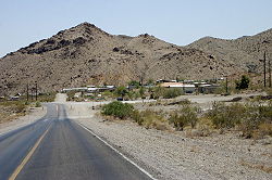
. From there, the state highway follows Nelson Road in a southeasterly direction through Eldorado Valley
11 miles (17.7 km) to its end just outside the town of Nelson. The town of Nelson was established in 1905 following several mining claims being discovered in the valley. Although the small community is still inhabited, the remains of many mining operations and abandoned structures can still be seen in the vicinity.
 The route first appears on state highway maps in 1941 as part of State Route 60, a three-pronged route with each spoke connecting to the town of Nelson. The 16 miles (25.7 km) northwest leg connected to US 95 about 4 miles (6.4 km) south of Boulder City while the 10 miles (16.1 km) southwest leg reached US 95 further south via the Nelson Cutoff Road. The third leg of SR 60 ran east from Nelson 7 miles (11.3 km) to the Colorado River
. Both the northwest and eastern legs of the route were completely paved by 1951.
State Route 60 remained largely unchanged until the Nevada began renumbering of its state highway system on July 1, 1976. The northwest leg of old SR 60 was renumbered to State Route 165 in this process, and by this time was realigned to be only 12 miles (19.3 km) long. The remaining legs of SR 60 have since gone unnumbered.
U.S. state
A U.S. state is any one of the 50 federated states of the United States of America that share sovereignty with the federal government. Because of this shared sovereignty, an American is a citizen both of the federal entity and of his or her state of domicile. Four states use the official title of...
of Nevada
Nevada
Nevada is a state in the western, mountain west, and southwestern regions of the United States. With an area of and a population of about 2.7 million, it is the 7th-largest and 35th-most populous state. Over two-thirds of Nevada's people live in the Las Vegas metropolitan area, which contains its...
. The road connects the town of Nelson
Nelson, Nevada
Nelson is an unincorporated community in Clark County, Nevada, United States, in the Las Vegas metropolitan area. The community is in the Pacific Standard Time zone. The location of Nelson is in El Dorado Canyon, Eldorado Mountains...
to U.S. Route 95. The road originated in the 1940s and was one section of former State Route 60 until the 1970s.
Route description
Boulder City, Nevada
Boulder City is a city in Clark County, Nevada, United States. It is approximately from the City of Las Vegas. As of the 2010 census the population of Boulder City was 15,023.Boulder City is one of only two cities in Nevada that prohibit gambling....
. From there, the state highway follows Nelson Road in a southeasterly direction through Eldorado Valley
Eldorado Valley
Eldorado Valley, or El Dorado Valley, is a Great Basin valley in the Mojave Desert southeast of Las Vegas and southwest of Boulder City, Nevada...
11 miles (17.7 km) to its end just outside the town of Nelson. The town of Nelson was established in 1905 following several mining claims being discovered in the valley. Although the small community is still inhabited, the remains of many mining operations and abandoned structures can still be seen in the vicinity.
History
Colorado River
The Colorado River , is a river in the Southwestern United States and northwestern Mexico, approximately long, draining a part of the arid regions on the western slope of the Rocky Mountains. The watershed of the Colorado River covers in parts of seven U.S. states and two Mexican states...
. Both the northwest and eastern legs of the route were completely paved by 1951.
State Route 60 remained largely unchanged until the Nevada began renumbering of its state highway system on July 1, 1976. The northwest leg of old SR 60 was renumbered to State Route 165 in this process, and by this time was realigned to be only 12 miles (19.3 km) long. The remaining legs of SR 60 have since gone unnumbered.