

Nevada State Route 161
Encyclopedia
State Route 161 is a state highway in Clark County
, Nevada
. It is known as Goodsprings Road, connecting the town of Goodsprings
to Interstate 15 at Jean
. The route was part of State Route 53 prior to 1976.
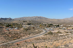 The route begins at the intersection of Esmeralda Street and Spring Street in Goodsprings. It runs east along Spring Street, then exits the town and heads southeastward, intersecting Sandy Valley Road in the Mojave Desert
. The road continues southeastward for about 7 miles (11.3 km) before entering Jean. SR 161 ends in Jean at an interchange with Interstate 15
 A connection between Goodsprings and U.S. Route 91 (and SR 6) at Jean first appeared on official Nevada state maps in 1933. At that time, it was an unimproved county road. By 1935, that road was incorporated into State Route 53, which connected Jean to Goodsprings before curving southwest towards the California
state line. By 1941, the first 7 miles (11.3 km) of the SR 53 reaching Goodsprings was paved, with the remaining 13 miles (20.9 km) in to Sandy Valley
and on to California remained unimproved.
SR 53 remained unchanged until the 1976 renumbering of Nevada's state highway system that was authorized on July 1, 1976. In that process, the paved portion of the highway between Jean and Goodsprings was renumbered to State Route 161. This change was first seen on the 1978-1979 edition of the official state map The remaining section of SR 53 to Sandy Valley continued to be shown on the state map, but was dropped from the state system by 1982. Sandy Valley is now reachable via the Sandy Valley road turnoff from SR 161, prior to entering Goodsprings.
Clark County, Nevada
-Demographics:As of the census of 2000, there were 1,375,765 people, 512,253 households, and 339,693 families residing within the MSA. The racial makeup of the MSA was 71.6% White , 9.1% Black, 5.7% Asian, 0.8% American Indian and 12.8% of other or mixed race. 22.0% were Hispanic of any race...
, Nevada
Nevada
Nevada is a state in the western, mountain west, and southwestern regions of the United States. With an area of and a population of about 2.7 million, it is the 7th-largest and 35th-most populous state. Over two-thirds of Nevada's people live in the Las Vegas metropolitan area, which contains its...
. It is known as Goodsprings Road, connecting the town of Goodsprings
Goodsprings, Nevada
Goodsprings is a census-designated place in Clark County, Nevada, United States. The population was 232 at the 2000 census.-Geography:Goodsprings is located at ....
to Interstate 15 at Jean
Jean, Nevada
Jean is a small commercial town in Clark County, Nevada, located approximately north of the Nevada-California state line along Interstate 15. Las Vegas is located about to the north...
. The route was part of State Route 53 prior to 1976.
Route description
Mojave Desert
The Mojave Desert occupies a significant portion of southeastern California and smaller parts of central California, southern Nevada, southwestern Utah and northwestern Arizona, in the United States...
. The road continues southeastward for about 7 miles (11.3 km) before entering Jean. SR 161 ends in Jean at an interchange with Interstate 15
Interstate 15 in Nevada
In the U.S. State of Nevada, Interstate 15 begins in Primm, continues through Las Vegas and it crosses the border with Arizona in Mesquite. The freeway runs entirely in Clark County. Many motorists use Interstate 15 to visit Las Vegas, as it is the only primary Interstate Highway in the city. The...
History
California
California is a state located on the West Coast of the United States. It is by far the most populous U.S. state, and the third-largest by land area...
state line. By 1941, the first 7 miles (11.3 km) of the SR 53 reaching Goodsprings was paved, with the remaining 13 miles (20.9 km) in to Sandy Valley
Sandy Valley, Nevada
Sandy Valley is a census-designated place in the Mesquite Valley in west-central Clark County, Nevada, United States. Sandy Valley has variant name of Sandy, Nevada. The population was 1,804 at the 2000 census. Sandy Valley is bordered on the East by the southern extension of the Spring Mountains...
and on to California remained unimproved.
SR 53 remained unchanged until the 1976 renumbering of Nevada's state highway system that was authorized on July 1, 1976. In that process, the paved portion of the highway between Jean and Goodsprings was renumbered to State Route 161. This change was first seen on the 1978-1979 edition of the official state map The remaining section of SR 53 to Sandy Valley continued to be shown on the state map, but was dropped from the state system by 1982. Sandy Valley is now reachable via the Sandy Valley road turnoff from SR 161, prior to entering Goodsprings.