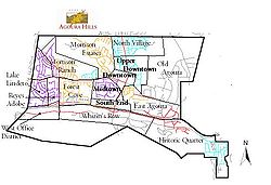
Neighborhoods of Agoura Hills, California
Encyclopedia
Agoura Hills, California
Agoura Hills is a city in Los Angeles County, California, and has the ZIP code 91301. The population was 20,330 at the 2010 census, down from 20,537 at the 2000 census. It is located in the eastern Conejo Valley between the Simi Hills and the Santa Monica Mountains. This city on the Ventura...
is unofficially divided into a number of varied districts centered around the modern Downtown area of the city. The most notable of these districts include:
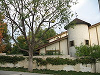
- DowntownDowntown, Agoura Hills, CaliforniaDowntown is the commercial and geographic heart of Agoura Hills, California, a district built mainly in the 1970s to replace the city's old heart in what is now the Historic Quarter....
- Hillrise
- South EndSouth End, Agoura Hills, CaliforniaSouth End is a neighborhood in Agoura Hills, California It is generally considered the southern edge of Downtown.In recent years the area has been experiencing a construction boom, arguably in part due to its fortuitous location between Downtown and Malibu Junction.Historically, the area was...
- Upper Downtown
- Old AgouraOld Agoura, Agoura Hills, CaliforniaThis Agoura Hills, California district is commonly referred to just as "Agoura" in colloquial speech. The area's mix of spacious estates and Western style houses has made it a magnet for equestrian enthusiasts, and a network of horse trails connects much of the area to the centrally located Old...
- East AgouraEast Agoura, Agoura Hills, CaliforniaEast Agoura is a district of Agoura Hills, California, located on the city's east side.East Agoura is arguably the most dense of the Agoura Hills districts, as the area contains a mix of apartment buildings and large offices as a result of construction in the 1990s.This district is located...
- Malibu JunctionMalibu Junction, Agoura Hills, CaliforniaMalibu Junction is an Agoura Hills Neighborhood in southern Agoura Hills, western Los Angeles County, California. Malibu Junction is located in the eastern Conejo Valley between the Simi Hills and the Santa Monica Mountains. This district is on the Ventura Freeway Malibu Junction (also known as...
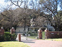
- Historic QuarterHistoric Quarter, Agoura Hills, CaliforniaThe Historic Quarter is the southeastern most district of Agoura Hills, California.The Historic Quarter is made up of two sections- the buildings along and just south of Agoura Rd. that are akin to a town's Main Street, as well the development from Cornell Rd. on the north side to Agoura Rd...
- Forest CoveForest Cove, Agoura Hills, CaliforniaForest Cove is a neighborhood of Agoura Hills, California.This residential district is composed of relatively compact detached homes, some reminiscent of the French Provincial style of architecture, with the large Forest Cove Park as the community's center....
' - Morrison RanchMorrison Ranch, Agoura Hills, CaliforniaMorrison Ranch is a residential district of Agoura Hills, California.Morrison Ranch is made up mostly of upper-middle class detached homes along Agoura Hills' north side. It is tranquil and relatively removed from the hubbub of Downtown...
- Lake LinderoLake Lindero, Agoura Hills, CaliforniaLake Lindero is a man-made lake in Agoura Hills, California, United States. "Lake Lindero" also refers to the district immediately surrounding this lake....
- Reyes Adobe
- North Village
- Morrison Estates
- Fountainwood