

National Register of Historic Places listings in Wilson County, North Carolina
Encyclopedia
National Register of Historic Places
The National Register of Historic Places is the United States government's official list of districts, sites, buildings, structures, and objects deemed worthy of preservation...
in Wilson County, North Carolina
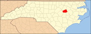
Wilson County, North Carolina
-Demographics:As of the census of 2006, there 73,814 people, 28,613 households, and 19,771 families residing in the county. The population density was 199 people per square mile . There were 30,729 housing units at an average density of 83 per square mile...
. Click the "Map of all coordinates" link to the right to view a Google map of all properties and districts with latitude and longitude coordinates in the table below.
| Landmark name | Image | Date listed | Location | City or Town | Summary | |
|---|---|---|---|---|---|---|
| 1 | W. H. Applewhite House | Off NC 58 35°37′25"N 77°49′18"W |
Stantonsburg | |||
| 2 | Manalcus Aycock House | Center St. 35°38′5"N 77°56′2"W |
Black Creek | |||
| 3 | Gen. Joshua Barnes House | W side of SR 1326 at SR 1327 35°45′44"N 77°54′9"W |
Wilson | |||
| 4 | Black Creek Rural Historic District | Along NC 1628 35°37′36"N 77°53′22"W |
Black Creek | |||
| 5 | Branch Banking | 124 W. Nash St. 35°43′29"N 77°54′36"W |
Wilson | |||
| 6 | Broad-Kenan Streets Historic District | Roughly bounded by Pine, Broad, Hines and Cone 35°43′44"N 77°55′4"W |
Wilson | |||
| 7 | Bullock-Dew House | NC 581 35°44′22"N 78°6′43"W |
Sims | |||
| 8 | Cherry Hotel | 333 E. Nash St. 35°43′56"N 77°54′32"W |
Wilson | |||
| 9 | Davis-Whitehead-Harriss House | 600 W. Nash St. 35°43′56"N 77°54′58"W |
Wilson | |||
| 10 | East Wilson Historic District | Roughly bounded by E. Gold and Academy Sts., Ward Blvd., Woodard Street Ave. and Elvie St., and Railroad and Pender Sts. 35°43′10"N 77°54′10"W |
Wilson | |||
| 11 | Edmondson-Woodward House | NC 58 and SR 1542 35°39′8"N 77°49′57"W |
Stantonsburg | |||
| 12 | Elm City Municipal Historic District | Roughly bounded by North, Pender and Branch, Wilson, and Anderson Sts. 35°48′28"N 77°51′45"W |
Elm City | |||
| 13 | W. H. Langley House | N side of SR 1003 35°48′31"N 77°52′45"W |
Elm City | |||
| 14 | Lucama Municipal Historic District | Roughly bounded by US 301 and Railroad St., Main St., Black Creek Rd., and Goldsboro St. 35°38′35"N 78°0′38"W |
Lucama | |||
| 15 | Dr. H. D. Lucas House | Center St. 35°38′12"N 77°56′4"W |
Black Creek | Demolished | ||
| 16 | Old Wilson Historic District | Roughly bounded by Nash, N. Cone, Gold and Railroad Sts. and Maplewood Cemetery 35°43′51"N 77°54′38"W |
Wilson | |||
| 17 | Joseph John Pender House | SR 1418 and SR 1002 35°46′17"N 77°46′28"W |
Wilson | |||
| 18 | Moses Rountree House | 107 N. Rountree St. 35°44′2"N 77°54′55"W |
Wilson | |||
| 19 | Maj. James Scarborough House | NC 222 35°39′46"N 77°46′3"W |
Saratoga | |||
| 20 | Alfred and Martha Jane Thompson House and Williams Barn | NC 1314, 0.4 miles W of NC 58 35°48′36"N 77°57′18"W |
New Hope | |||
| 21 | Upper Town Creek Rural Historic District | Roughly bounded by NC 1003, NC 1411, NC 1414, and Town Creek 35°47′57"N 77°45′25"W |
Wilson | |||
| 22 | Ward-Applewhite-Thompson House | S side of SR 1539 35°36′16"N 77°47′47"W |
Stantonsburg | |||
| 23 | Webb-Barron-Wells House | E side SR 1512 35°45′37"N 77°44′8"W |
Elm City | |||
| 24 | West Nash Street Historic District | West Nash St. 35°44′18"N 77°55′14"W |
Wilson | |||
| 25 | Olzie Whitehead Williams House | SR 1332 35°47′22"N 77°55′8"W |
Wilson | |||
| 26 | Wilson Central Business-Tobacco Warehouse Historic District | Roughly bounded by Pender, Green, Pine, S. Jackson, and Hines Sts. 35°43′26.17"N 77°54′41"W |
Wilson | |||
| 27 | Wilson County Courthouse Wilson County Courthouse (Wilson, North Carolina) Wilson County Courthouse in Wilson, North Carolina was built in 1924. It was listed on the National Register of Historic Places in 1979.... |
Nash at Goldsboro St. 35°43′31"N 77°53′41"W |
Wilson | |||
| 28 | Woodard Family Rural Historic District | Along US 264 35°41′30"N 77°50′18"W |
Wilson |
See also
- National Register of Historic Places listings in North Carolina
- List of National Historic Landmarks in North Carolina