

National Register of Historic Places listings in Warren County, Iowa
Encyclopedia

This is intended to be a complete list of the properties and districts on the National Register of Historic Places
National Register of Historic Places
The National Register of Historic Places is the United States government's official list of districts, sites, buildings, structures, and objects deemed worthy of preservation...
in Warren County, Iowa
Iowa
Iowa is a state located in the Midwestern United States, an area often referred to as the "American Heartland". It derives its name from the Ioway people, one of the many American Indian tribes that occupied the state at the time of European exploration. Iowa was a part of the French colony of New...
, United States
United States
The United States of America is a federal constitutional republic comprising fifty states and a federal district...
. Latitude and longitude coordinates are provided for many National Register properties and districts; these locations may be seen together in a Google map.
There are 12 properties and districts listed on the National Register in the county.
Current listings
| Landmark name | Image | Date listed | Location | City or Town | Summary | |
|---|---|---|---|---|---|---|
| 1 | Coal Creek Bridge | 2404 Fillmore St. over Coal Creek 41°25′44"N 93°20′46"W |
Carlisle Carlisle, Iowa Carlisle is a city in Warren and Polk counties in the U.S. state of Iowa. The population was 3,497 at the 2000 census. The city is part of the Des Moines–West Des Moines Metropolitan Statistical Area.... |
|||
| 2 | Hoosier Row School | 15246 County Road R63 41°18′15"N 93°37′2"W |
Indianola Indianola, Iowa As of the census of 2000, there were 12,998 people, 4,748 households, and 3,261 families residing in the city. The population density was 1,414.7 people per square mile . There were 4,981 housing units at an average density of 542.1 per square mile... vicinity |
|||
| 3 | Indianola High School | 301 N. Buxton 41°21′46"N 93°33′45"W |
Indianola Indianola, Iowa As of the census of 2000, there were 12,998 people, 4,748 households, and 3,261 families residing in the city. The population density was 1,414.7 people per square mile . There were 4,981 housing units at an average density of 542.1 per square mile... |
|||
| 4 | Lake Ahquabi State Park Lake Ahquabi State Park Lake Ahquabi State Park is a state park of Iowa, USA, featuring a reservoir. Ahquabi means "resting place" in the Fox language. The park is south of Indianola and south of Des Moines.-History:... , Picnic Area (Area A) |
1650 118th Ave. 41°17′23"N 93°35′1"W |
Indianola Indianola, Iowa As of the census of 2000, there were 12,998 people, 4,748 households, and 3,261 families residing in the city. The population density was 1,414.7 people per square mile . There were 4,981 housing units at an average density of 542.1 per square mile... |
|||
| 5 | Lake Ahquabi State Park Lake Ahquabi State Park Lake Ahquabi State Park is a state park of Iowa, USA, featuring a reservoir. Ahquabi means "resting place" in the Fox language. The park is south of Indianola and south of Des Moines.-History:... , Bathhouse Area (Area B) |
1650 118th Ave. 41°17′25"N 93°35′25"W |
Indianola Indianola, Iowa As of the census of 2000, there were 12,998 people, 4,748 households, and 3,261 families residing in the city. The population density was 1,414.7 people per square mile . There were 4,981 housing units at an average density of 542.1 per square mile... |
|||
| 6 | Lake Ahquabi State Park Lake Ahquabi State Park Lake Ahquabi State Park is a state park of Iowa, USA, featuring a reservoir. Ahquabi means "resting place" in the Fox language. The park is south of Indianola and south of Des Moines.-History:... , Refectory Area (Area C) |
1650 118th Ave. 41°17′19"N 93°35′25"W |
Indianola Indianola, Iowa As of the census of 2000, there were 12,998 people, 4,748 households, and 3,261 families residing in the city. The population density was 1,414.7 people per square mile . There were 4,981 housing units at an average density of 542.1 per square mile... |
|||
| 7 | Octagon Barn, Otter Township Octagon Barn, Otter Township The Octagon Barn, Otter Township is an historic structure located near Milo in rural Warren County, Iowa, United States. It was built in 1900 and has been listed on the National Register of Historic Places since 1986. The building measures 54 feet around. The structure features a tall center... |
Off Iowa Highway 205 41°16′7"N 93°26′35"W |
Otter Township | |||
| 8 | Palmyra Methodist Episcopal Church | Southwest of Hartford 41°26′4"N 93°26′5"W |
Palmyra | |||
| 9 | Polled Hereford Breed Origin Site | Southwest of Indianola 41°15′32"N 93°40′54"W |
Indianola Indianola, Iowa As of the census of 2000, there were 12,998 people, 4,748 households, and 3,261 families residing in the city. The population density was 1,414.7 people per square mile . There were 4,981 housing units at an average density of 542.1 per square mile... |
|||
| 10 | Science Hall | Simpson College Simpson College Simpson College is a four-year, coeducational liberal arts institution situated in Indianola, Iowa, USA, and affiliated with the United Methodist Church. Simpson, which has been fully accredited by North Central Association since 1913, is a small school with approximately 1,400 full-time students... campus 41°21′54"N 93°34′25"W |
Indianola Indianola, Iowa As of the census of 2000, there were 12,998 people, 4,748 households, and 3,261 families residing in the city. The population density was 1,414.7 people per square mile . There were 4,981 housing units at an average density of 542.1 per square mile... |
|||
| 11 | United Presbyterian Church, Summerset | U.S. Route 65 U.S. Route 65 U.S. Route 65 is a north–south United States highway in the southern and midwestern United States. The southern terminus of the route is at U.S. Route 425 in Clayton, Louisiana. The northern terminus is at Interstate 35 just south of Interstate 90 in Albert Lea, Minnesota... 41°28′16"N 93°33′38"W |
Scotch Ridge | |||
| 12 | Warren County Court House Warren County Court House The Warren County Court House in Indianola, Iowa, United States was built in 1939. It was listed on the National Register of Historic Places in 2003 as a part of the PWA-Era County Courthouses of IA Multiple Properties Submission... |
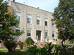 |
115 N. Howard Ave. 41°21′40"N 93°33′41"W |
Indianola Indianola, Iowa As of the census of 2000, there were 12,998 people, 4,748 households, and 3,261 families residing in the city. The population density was 1,414.7 people per square mile . There were 4,981 housing units at an average density of 542.1 per square mile... |
See also
- List of National Historic Landmarks in Iowa
- National Register of Historic Places listings in Iowa