

National Register of Historic Places listings in New Hanover County, North Carolina
Encyclopedia
National Register of Historic Places
The National Register of Historic Places is the United States government's official list of districts, sites, buildings, structures, and objects deemed worthy of preservation...
in New Hanover County, North Carolina
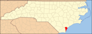
New Hanover County, North Carolina
-Demographics:As of the census of 2000, there were 160,307 people, 68,183 households, and 41,591 families residing in the county. The population density was 806 people per square mile . There were 79,616 housing units at an average density of 400 per square mile...
. Click the "Map of all coordinates" link to the right to view a Google map of all properties and districts with latitude and longitude coordinates in the table below.
| Landmark name | Image | Date listed | Location | City or Town | Summary | |
|---|---|---|---|---|---|---|
| 1 | Audubon Trolley Station | Jct. of Park Ave. and Audubon Blvd. 34°12′55"N 77°53′47"W |
Wilmington | |||
| 2 | Bradley-Latimer Summer House | S side SR 1411 E of jct. with US 76 34°12′55"N 77°49′52"W |
Wrightsville Beach | |||
| 3 | Cape Fear Civil War Shipwreck Discontiguous District | Address Restricted | Kure Beach, Wrightsville Beach and Wilmington Beach | |||
| 4 | Carolina Heights Historic District | Roughly bounded by Market St., Thirteenth St., Rankin St. and Nineteenth St.; also the 1200 block of Market St. and the 100 and 200 blocks of N. 13th St. 34°14′21"N 77°55′44"W |
Wilmington | Second set of addresses represents a boundary increase of | ||
| 5 | Carolina Place Historic District | Bounded by Market St., Wallace Park, Gibson Ave., Wrightsville Ave. and S. Eighteenth St. 34°14′6"N 77°55′24"W |
Wilmington | |||
| 6 | City Hall/Thalian Hall | 100 N. 3rd. St. 34°14′14"N 77°56′48"W |
Wilmington | |||
| 7 | Delgrado School | 1930 Colwell Ave. 34°13′45"N 77°55′21"W |
Wilmington | |||
| 8 | Federal Building and Courthouse | N. Water between Market and Princess St. 34°14′7"N 77°57′0"W |
Wilmington | |||
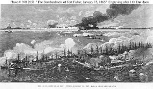
| 9 | Fort Fisher Fort Fisher Fort Fisher was a Confederate fort during the American Civil War. It protected the vital trading routes of the port at Wilmington, North Carolina, from 1861 until its capture by the Union in 1865.... |
 |
18 miles S of Wilmington on U.S. 421 33°57′57"N 77°55′37"W |
Wilmington | ||
| 10 | Gabriel's Landing | 1005 Airlie Rd. | Wilmington | |||
| 11 | Homesite (31Nh95**1) | Address Restricted | Carolina Beach | |||
| 12 | William Hooper School (Former) | 410 Meares St. 34°13′17"N 77°56′34"W |
Wilmington | |||
| 13 | Joy Lee Apartment Building and Annex | 317 Carolina Beach Ave., N. 34°2′14"N 77°53′30"W |
Carolina Beach | |||
| 14 | Market Street Mansion District | 1704, 1705, 1710, and 1713 Market St. 34°14′12"N 77°55′38"W |
Wilmington | |||
| 15 | Masonboro Sound Historic District | E side Magnolia Dr. and 7301-7601, 7424 and 7506 Masonboro Sound Rd. 34°10′40"N 77°50′45"W |
Wilmington | |||
| 16 | Mount Lebanon Chapel and Cemetery Mount Lebanon Chapel and Cemetery Mount Lebanon Chapel and Cemetery is a historic chapel and cemetery at SR 1411 in Wrightsville Beach, North Carolina.It was built in 1835 and added to the National Register in 1986.-References:... |
SR 1411 34°12′50"N 77°49′35"W |
Wrightsville Beach | |||
| 17 | Newton Homesite and Cemetery | Address Restricted | Carolina Beach | |||
| 18 | Sunset Park Historic District Sunset Park Historic District Sunset Park is a neighborhood south of the Historic Downtown of Wilmington, in New Hanover County, North Carolina, United States . It has been designated a Historic District on the National Register of Historic Places.... |
Roughly bounded by Carolina Beach Rd., Southern Blvd., Burnett Blvd., and Sunset Ave. 34°12′14"N 77°56′45"W |
Wilmington | |||
| 19 | Tinga Nursery | US 117, 0.62 miles N of jct. with NC 132 34°17′55"N 77°55′4"W |
Wrightsboro | |||
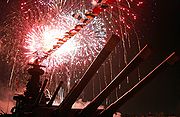
| 20 | USS NORTH CAROLINA (BB-55) National Historic Landmark USS North Carolina (BB-55) USS North Carolina was the lead ship of her class of battleship and the fourth in the United States Navy to be named in honor of this U.S. state. She was the first new-construction U.S. battleship to enter service during World War II, participating in every major naval offensive in the Pacific... |
 |
W bank of the Cape Fear River 34°14′11.42"N 77°57′15.96"W |
Wilmington | ||
| 21 | U.S.S. PETERHOFF USS Peterhoff (1863) USS Peterhoff was a British blockade runner captured by the Union Navy during the American Civil War. She served the Union Navy’s struggle against the Confederate States of America as a patrol gunship.... |
Address Restricted | Fort Fisher | |||
| 22 | James Walker Nursing School Quarters | 1020 Rankin St. 34°14′27"N 77°56′11"W |
Wilmington | |||
| 23 | Westbrook-Ardmore Historic District | Bounded by Dock St., Wrightsville Ave., Queen and Lingo Sts., and by S. 14th St. 34°13′55.26"N 77°55′39.59"W |
Wilmington | |||
| 24 | Wilmington Historic and Archeological District | Roughly bounded by Wright, S. 7th, and Harnett Sts., and N/S line 100 yds. W of North East Cape Fear River; also roughly bounded by Harnett, 7th, 3rd, and Howard, Campbell, 9th, 12th, and Princess, Dock, Castle 8th, and 14th, and 9th, Wright, and Greenfield 34°14′6"N 77°57′3"W |
Wilmington | Second set of boundaries represents a boundary increase of , the Wilmington Historic District | ||
| 25 | Wilmington National Cemetery Wilmington National Cemetery Wilmington National Cemetery is a United States National Cemetery located in the city of Wilmington, in New Hanover County, North Carolina. It encompasses , and as of the end of 2005, had 6,171 interred remains.- History :... |
2011 Market St. 34°14′16"N 77°55′33"W |
Wilmington |
See also
- National Register of Historic Places listings in North Carolina
- List of National Historic Landmarks in North Carolina