

National Register of Historic Places listings in Linn County, Oregon
Encyclopedia
This is a list of properties and districts in Linn County, Oregon
that are listed on the National Register of Historic Places
.
Linn County, Oregon
Linn County is a county located in the U.S. state of Oregon. It is named in honor of Lewis F. Linn, a U.S. Senator from Missouri who advocated the American occupation of the Oregon Country. By the 2010 US census the population of Linn county was 116,672 showing a 13.2% growth since the 2000 census...
that are listed on the National Register of Historic Places
National Register of Historic Places
The National Register of Historic Places is the United States government's official list of districts, sites, buildings, structures, and objects deemed worthy of preservation...
.
Current listings
| Landmark name | Image | Date listed | Location | City or Town | Summary | |
|---|---|---|---|---|---|---|
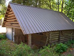
| 1 | David and Maggie Aegerter Barn David and Maggie Aegerter Barn The David and Maggie Aegerter Barn is a gambrel-roofed barn in Linn County, in northwestern Oregon, that was built in 1915. It was listed on the U.S. National Register of Historic Places in 1999.... |
41915 Ridge Dr. 44°44′54"N 122°44′37"W |
Scio | |||
| 2 | Albany Custom Mill | 213 Water St. 44°38′18"N 123°6′23"W |
Albany | |||
| 3 | Albany Downtown Commercial Historic District | Roughly bounded by the Willamette River and Montgomery, Washington, and 5th Sts. 44°38′12"N 123°6′22"W |
Albany | |||
| 4 | Albany Monteith Historic District Albany Monteith Historic District The Albany Monteith Historic District, also known as Monteith Historic District, in Albany, Oregon, United States, was listed on the National Register of Historic Places in 1980. It includes the Alfred Dawson House, which is separately listed on the NRHP... |
Roughly bounded by 2nd, Lyon, 12th and Elm Sts.; also Elm St. southwest to Calapooia and 19th Ave., SW. to 11th and 12th Aves., SW. 44°37′55"N 123°6′31"W |
Albany | Second set of boundaries represents a boundary increase of | ||
| 5 | Albany Municipal Airport Albany Municipal Airport (Oregon) Albany Municipal Airport is a general aviation airport located east of the city of Albany in Linn County, Oregon, United States. It is publicly owned and operated by the City of Albany. It is the oldest known operating airfield in Oregon, opening in 1920. There are 58 aircraft based at the... |
3510 Knox Butte Rd. 44°38′24"N 123°3′29"W |
Albany | |||
| 6 | Steven and Elizabeth Archibald Farmstead | 31888 Wirth Rd. 44°30′47"N 123°4′46"W |
Tangent | |||
| 7 | Jerry Andrus House | 1638 1st Ave. E. 44°38′22"N 123°5′6"W |
Albany | |||
| 8 | Granville H. Baber House | Northeast of Albany off U.S. 99 44°40′43"N 123°1′18"W |
Albany | |||
| 9 | Hiram Baker House | 515 E. Grant St. 44°32′18"N 122°53′53"W |
Lebanon | |||
| 10 | Dr. J. C. Booth House | 486 Park St. 44°32′29"N 122°54′17"W |
Lebanon | |||
| 11 | Boston Flour Mill Boston Flour Mill Boston Flour Mill is a historic gristmill in Shedd, Oregon.It was built in 1863 and added to the National Register of Historic Places in 1979. It is part of the Thompson's Mills State Heritage Site.... |
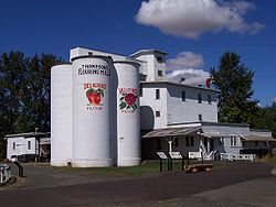 |
E of Shedd on Boston Mill Rd. 44°27′41"N 123°4′47"W |
Shedd | ||
| 12 | Hugh Leeper Brown Barn | SE of Brownsville on OR 228 44°22′52"N 122°57′28"W |
Brownsville | |||
| 13 | John and Amelia Brown Farmhouse | SE of Brownsville on OR 228 44°22′56"N 122°57′53"W |
Brownsville | |||
| 14 | Cascadia Cave | Address Restricted | Cascadia | |||
| 15 | George Earle Chamberlain House | 208 SE 7th St. 44°37′58"N 123°6′3"W |
Albany | |||
| 16 | Matthew C. Chambers Barn | .4 mi. N of jct. of Knox Butte Rd. and Scravel Hill Rd. 44°39′11"N 123°1′23"W |
Albany | |||
| 17 | William Cochran Barn | 28485 Brownsville Rd. 44°25′18"N 122°59′13"W |
Brownsville | |||
| 18 | George C. Cooley House | 220 Blakely Ave. 44°23′6"N 122°58′53"W |
Brownsville | |||
| 19 | Crabtree Creek-Hoffman Covered Bridge |  |
Hungry Hill Dr., 1.8 mi. N of Crabtree 44°39′13"N 122°53′21"W |
Crabtree | ||
| 20 | Louis A. Crandall House | 959 Main St. 44°32′13"N 122°54′20"W |
Lebanon | |||
| 21 | Crawfordsville Bridge | SR 228 44°21′28"N 122°51′32"W |
Crawfordsville | |||
| 22 | Alfred Dawson House | 731 SW Broadalbin St. 44°38′28"N 123°6′18"W |
Albany | |||
| 23 | Elkins Flour Mill | Bounded by US 20, Industrial Way, the Santiam-Albany Canal and the Callaghan RR tracks 44°32′52"N 122°54′19"W |
Lebanon | |||
| 24 | Hugh Fields House | 36176 OR 228 44°22′51"N 122°56′29"W |
Brownsville | |||
| 25 | First Baptist Church of Brownsville | 515 N. Main St. 44°23′44"N 122°59′1"W |
Brownsville | |||
| 26 | First Evangelical Church of Albany | 1120 SW. 12th Ave. 44°37′38"N 123°6′52"W |
Albany | |||
| 27 | Flinn Block | 222 SW. 1st Ave. 44°38′13"N 123°6′21"W |
Albany | |||
| 28 | Hackleman Historic District | Roughly bounded by Pacific Boulevard and Lyons, 2nd and Madison Sts. 44°38′6"N 123°5′54"W |
Albany | |||
| 29 | Hannah Bridge | Burmester Creek Rd. 44°42′44"N 122°43′4"W |
Scio | |||
| 30 | Harrisburg Odd Fellows Hall Harrisburg Odd Fellows Hall The Harrisburg Odd Fellows Hall in Harrisburg, Oregon, also known as I.O.O.F. Covenant Lodge No. 12, was built in 1882. It was listed on the National Register of Historic Places in 1992 for its architecture, which is Italianate. It served historically as a meeting hall, as a theater, and as a... |
190 Smith St. 44°16′20"N 123°10′12"W |
Harrisburg | |||
| 31 | George Hochstedler House | 237 SE 6th Ave. 44°38′2"N 123°6′2"W |
Albany | |||
| 32 | C. J. Howe Building | 104 Spaulding Ave. 44°23′38"N 122°59′0"W |
Brownsville | |||
| 33 | Independence Prairie Ranger Station | Williamette National Forest 44°37′2"N 121°56′22"W |
Marion Forks | |||
| 34 | Larwood Bridge | E of Crabtree 44°37′48"N 122°44′21"W |
Crabtree | |||
| 35 | Lebanon Pioneer Cemetery | 200 Dodge St. 44°32′40"N 122°54′14"W |
Lebanon | |||
| 36 | Lebanon Southern Pacific Railroad Depot Lebanon Southern Pacific Railroad Depot The Lebanon Southern Pacific Railroad Depot is a former railway station located in Lebanon, Oregon, Oregon, listed on the National Register of Historic Places. It was constructed in 1908 for use by the Southern Pacific Company , to replace an 1880 depot that had become too small for the amount of... |
735 Third St. 44°32′19.8"N 122°54′36.3"W |
Lebanon | |||
| 37 | Hector and Margaret Macpherson Barn | 29780 Church Dr. 44°30′42"N 123°11′32"W |
Albany | |||
| 38 | Marion Forks Guard Station Marion Forks Guard Station The Marion Forks Guard Station was built in 1935. It was listed on the National Register of Historic Places in 1991.... |
 |
OR 22, Willamette NF 44°36′51"N 121°56′56"W |
Marion Forks | ||
| 39 | Joseph and Barbara Maurer House | 35168 Tennessee Rd. 44°36′14"N 122°55′21"W |
Lebanon | |||
| 40 | Methodist Episcopal Church South | 238 E. 3rd St 44°38′10"N 123°6′4"W |
Albany | |||
| 41 | Gottlieb and Della Milde Barn | 36898 Northern Dr. 44°22′34"N 122°54′55"W |
Brownsville | |||
| 42 | Thomas and Walter Monteith House | 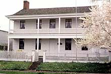 |
518 W. 2nd Ave. 44°38′10"N 123°6′33"W |
Albany | ||
| 43 | John and Mary Moore House | 320 Kirk Ave. 44°23′33"N 122°58′49"W |
Brownsville | |||
| 44 | John M. Moyer House | 204 Main St. 44°23′35"N 122°59′3"W |
Brownsville | |||
| 45 | Mt. Pleasant Presbyterian Church Mt. Pleasant Presbyterian Church The Mt. Pleasant Presbyterian Church, known as Christian Church at Mt. Pleasant or Mt. Pleasant Community Church, was built in 1856 near Stayton, Oregon. It was listed on the National Register of Historic Places in 1974 for its architecture.... |
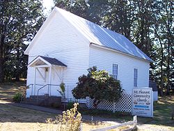 |
S of Stayton on Stayton-Jordan Rd. 44°45′31"N 122°44′38"W |
Stayton | ||
| 46 | Moses Parker House | 638 SE 5th St. 44°38′9"N 123°5′45"W |
Albany | |||
| 47 | Oregon Pacific Railroad Linear Historic District | Roughly a 20 mile section of the old railroad grade between Indanha and the Cascade Range summit 44°27′10"N 121°53′57"W |
Santiam Junction | Apparently in three counties: Jefferson, Linn, and Marion County. | ||
| 48 | E. C. Perry Building | 38731 N. Main St. 44°42′18"N 122°50′50"W |
Scio | |||
| 49 | Porter-Brasfield House | 31838 Fayetteville Dr. 44°27′41"N 123°6′36"W |
Shedd | |||
| 50 | John and Lottie Ralston Cottage | 481 Main St. 44°32′29"N 122°54′20"W |
Lebanon | |||
| 51 | John Ralston House | 632 SE Baker St. 44°37′59"N 123°6′6"W |
Albany | |||
| 52 | Rock Hill School | Rock Hill Dr., 2.2 mi. E of Sand Ridge Rd. 44°28′59"N 122°56′50"W |
Lebanon | |||
| 53 | Ross-Averill House | 420 Averill St. 44°23′41"N 122°59′4"W |
Brownsville | |||
| 54 | Michael and Mary Ryan Barn | 40363 Huntley Rd. 44°45′7"N 122°44′26"W |
Scio | |||
| 55 | Santiam Wagon Road Santiam Wagon Road The Santiam Wagon Road was a freight route in the U.S. state of Oregon between the Willamette Valley and Central Oregon regions from 1865 to the 1930s. It is considered one of the most important historical routes in the state... |
Willamette National Forest Willamette National Forest The Willamette National Forest is a National Forest located in the central portion of the Cascade Range of US state of Oregon.It comprises 1,675,407 acres making it one of the largest national forests. Over 380,000 acres are designated wilderness which include seven major mountain peaks... and Deschutes National Forest Deschutes National Forest The Deschutes National Forest is a United States National Forest located in parts of Deschutes, Klamath, Lake, and Jefferson counties in central Oregon. It comprises 1.8 million acres along the east side of the Cascade mountains. In 1908, the Deschutes National Forest was established from parts... |
Cascadia Cascadia, Oregon Cascadia is an unincorporated community that was established in 1892 on the South Santiam River, east of the current city of Sweet Home, in Linn County, Oregon, United States. Originally a stage stop on the Santiam Wagon Road, then a summer resort also known as Cascadia Mineral Springs, Cascadia... and Sisters Sisters, Oregon Sisters is a city in Deschutes County, Oregon, United States. It is part of the Bend, Oregon Metropolitan Statistical Area. The population was 959 at the 2000 census, but more than doubled to 2038 as of the 2010 census.- History :... vicinity |
Extends into Deschutes County National Register of Historic Places listings in Deschutes County, Oregon This is a list of properties and districts in Deschutes County, Oregon that are listed on the National Register of Historic Places.-Current listings:... . |
||
| 56 | Short Bridge | High Deck Rd. 44°23′30"N 122°30′31"W |
Cascadia | |||
| 57 | James Alexander and Elmarion Smith Barn and Lame-Smith House | 28020 Powerline Rd. 44°24′18"N 123°7′6"W |
Halsey | |||
| 58 | Starr and Blakely Drug Store | 421 N. Main St. 44°23′40"N 122°59′1"W |
Brownsville | |||
| 59 | Gus and Emma Stellmacher Farmstead | 32404 Tangent Loop 44°31′29"N 123°5′36"W |
Tangent | |||
| 60 | Thomas Creek-Gilkey Covered Bridge | Goar Rd., 3 mi. N of Crabtree 44°41′17"N 122°54′8"W |
Crabtree Crabtree, Oregon Crabtree is an unincorporated community in Linn County, Oregon, United States. Although it is unincorporated, it has a post office with a ZIP code of 97335. Crabtree lies off of Oregon Route 226 10 miles east of Albany.... |
|||
| 61 | Thomas Creek-Shimanek Covered Bridge | Richardson Gap Rd., 2 mi. E of Scio 44°42′57"N 122°48′12"W |
Scio Scio, Oregon Scio is a city in Linn County, Oregon, United States. The population was 838 at the 2010 census.-Geography:According to the United States Census Bureau, the city has a total area of , all of it land.-History:... |
|||
| 62 | United Presbyterian Church and Rectory United Presbyterian Church and Rectory (Albany, Oregon) The Albany Presbyterian Church and Rectory, also known as Whitespires, is a historic church building in Albany, Oregon, United States. It was built in 1891 in the Carpenter Gothic style. It was listed on the National Register of Historic Places in 1979... |
510 SW 5th Ave. 44°38′5"N 123°6′27"W |
Albany Albany, Oregon Albany is the eleventh largest city in the U.S. state of Oregon, and is the county seat of Linn County. It is located in the Willamette Valley at the confluence of the Calapooia River and the Willamette River in both Linn and Benton counties, just east of Corvallis and south of Salem. It is... |
|||
| 63 | United Presbyterian Church of Shedd | 30045 OR 99 E 44°27′38"N 123°6′31"W |
Shedd | |||
| 64 | Joseph Wesely House and Barn Joseph Wesely House and Barn Joseph Wesely House and Barn in Scio, Oregon was built in 1913. It was listed on the National Register of Historic Places in 1986.-External links:*... |
38791 OR 226 44°41′51"N 122°50′52"W |
Scio | |||
| 65 | Wigle Cemetery | Belts Dr. 44°18′17"N 123°1′0"W |
Harrisburg | |||
| 66 | Abraham and Mary Wigle House | 34050 Belts Dr. 44°18′5"N 123°1′26"W |
Harrisburg | |||
| 67 | Jacob and Maranda K. Wigle Farmstead | 1119 Kirk Ave. 44°23′35"N 122°57′59"W |
Brownsville | |||
| 68 | Z.C.B.J. Tolstoj Lodge No. 224 Z.C.B.J. Tolstoj Lodge No. 224 The Z.C.B.J. Tolstoj Lodge No. 224, also known as Bohemian Hall or Tolstoj Sokol Lodge, is a historic building in rural Linn County southeast of Scio, Oregon, United States, that was built in 1911. It was listed on the National Register of Historic Places on September 14, 1995. It historically... |
37091 Richardson Gap Rd. 44°39′37"N 122°48′10"W |
Scio |
Former listings
| Landmark name | Image | Date listed/removed | Location | City or Town | Summary | |
|---|---|---|---|---|---|---|
| 1 | Angell-Brewster House Angell-Brewster House The Angell-Brewster House in Lebanon, Oregon is a building from 1855. It was listed on the National Register of Historic Places in 1992. It was removed from the register on April 20, 2011, after being demolished in 2010.-External links:... |
Listed Removed | 34191 Brewster Rd. 44°34′46"N 122°52′12"W |
Lebanon vicinity |