

National Register of Historic Places listings in Ketchikan Gateway Borough, Alaska
Encyclopedia

This is intended to be a complete list of the properties and districts on the National Register of Historic Places
National Register of Historic Places
The National Register of Historic Places is the United States government's official list of districts, sites, buildings, structures, and objects deemed worthy of preservation...
in Ketchikan Gateway Borough
Ketchikan Gateway Borough, Alaska
As of the census of 2000, there were 14,070 people, 5,399 households, and 3,633 families residing in the borough. The population density was 11 people per square mile . There were 6,218 housing units at an average density of 5 per square mile...
, Alaska
Alaska
Alaska is the largest state in the United States by area. It is situated in the northwest extremity of the North American continent, with Canada to the east, the Arctic Ocean to the north, and the Pacific Ocean to the west and south, with Russia further west across the Bering Strait...
, United States
United States
The United States of America is a federal constitutional republic comprising fifty states and a federal district...
. The locations of National Register properties and districts for which the latitude and longitude coordinates are included below, may be seen in a Google map.
There are 18 properties and districts listed on the National Register in the borough.
Current listings
| Landmark name | Image | Date listed | Location | Community | Summary | |
|---|---|---|---|---|---|---|
| 1 | Alaska Totems |  |
Between Park and Deermount Avenues 55°20′35"N 131°37′55"W |
Ketchikan Ketchikan, Alaska Ketchikan is a city in Ketchikan Gateway Borough, Alaska, United States, the southeasternmost sizable city in that state. With an estimated population of 7,368 in 2010 within the city limits, it is the fifth most populous city in the state.... |
||
| 2 | Burkhart-Dibrell House | 500 Main Street 55°20′38"N 131°38′54"W |
Ketchikan Ketchikan, Alaska Ketchikan is a city in Ketchikan Gateway Borough, Alaska, United States, the southeasternmost sizable city in that state. With an estimated population of 7,368 in 2010 within the city limits, it is the fifth most populous city in the state.... |
|||
| 3 | Chief Kashakes House | Mile 2.5 South Tongass Highway Alaska Route 7 Alaska Route 7 is a state highway in the Alaska Panhandle of the U.S. state of Alaska. It consists of four unconnected pieces, serving some of the Panhandle communities that the Alaska Marine Highway ferries stop at, and connecting to the Alaska Highway in Yukon via the Haines Highway.-Route... 55°19′8"N 131°35′45"W |
Saxman Saxman, Alaska Saxman is a city on Revillagigedo Island in Ketchikan Gateway Borough in southeastern Alaska, United States. At the 2000 census the population was 431. The city of Ketchikan lies just to its northwest.-Geography:... |
|||
| 4 | Clover Pass School | Potter Road off Knudson Cove Road 55°28′22"N 131°47′27"W |
Knudson Cove | |||
| 5 | First Lutheran Church | 1200 Tongass Avenue 55°20′43"N 131°39′28"W |
Ketchikan Ketchikan, Alaska Ketchikan is a city in Ketchikan Gateway Borough, Alaska, United States, the southeasternmost sizable city in that state. With an estimated population of 7,368 in 2010 within the city limits, it is the fifth most populous city in the state.... |
|||
| 6 | Gilmore Building | 326 Front Street 55°20′32.5"N 131°38′52"W |
Ketchikan Ketchikan, Alaska Ketchikan is a city in Ketchikan Gateway Borough, Alaska, United States, the southeasternmost sizable city in that state. With an estimated population of 7,368 in 2010 within the city limits, it is the fifth most populous city in the state.... |
|||
| 7 | Guard Island Light Guard Island Light The Guard Island Light is a lighthouse located on a small island near the entrance to the Tongass Narrows, in Clarence Strait in southeastern Alaska. The western entrance to the Behm Canal also lies nearby.-History:... house |
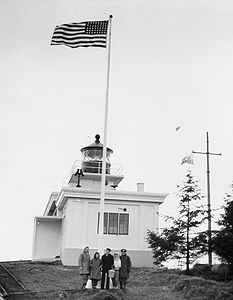 |
Guard Islands in the Clarence Strait Clarence Strait Clarence Strait, originally Duke of Clarence Strait, is a strait in southeastern Alaska, in the United States in the Alexander Archipelago. The strait separates Prince of Wales Island, on the west side, from Revillagigedo Island and Annette Island, on the east side... at the northern end of Tongass Narrow, 9.6 miles northwest of Ketchikan 55°25′52"N 131°51′46"W |
Ketchikan Ketchikan, Alaska Ketchikan is a city in Ketchikan Gateway Borough, Alaska, United States, the southeasternmost sizable city in that state. With an estimated population of 7,368 in 2010 within the city limits, it is the fifth most populous city in the state.... |
||
| 8 | Ketchikan Federal Building | 648 Mission St. 55°20′30"N 131°38′34"W |
Ketchikan Ketchikan, Alaska Ketchikan is a city in Ketchikan Gateway Borough, Alaska, United States, the southeasternmost sizable city in that state. With an estimated population of 7,368 in 2010 within the city limits, it is the fifth most populous city in the state.... |
|||
| 9 | Ketchikan Ranger House Ketchikan Ranger House Ketchikan Ranger House at 309 Gorge St. in Ketchikan, Alaska was built in 1915. It was listed on the National Register of Historic Places in 1987. It was designed by USDA Forest Service in "Vernacular Victorian" style. It served historically as institutional housing.It was built for $650 to... |
309 Gorge St. 55°20′50"N 131°39′32"W |
Ketchikan Ketchikan, Alaska Ketchikan is a city in Ketchikan Gateway Borough, Alaska, United States, the southeasternmost sizable city in that state. With an estimated population of 7,368 in 2010 within the city limits, it is the fifth most populous city in the state.... |
|||
| 10 | Mary Island Light Station Mary Island Light The Mary Island Light Station is a lighthouse located on the northeastern part of Mary Island in southeastern Alaska, USA.-History:Mary Island Light Station was opened in 1903, and was one of a series of staffed lights established by the U.S. Government to guide ships through the treacherous waters... |
 |
Eastern shore of the northern end of Mary Island, between the Revillagigedo Channel Revillagigedo Channel Revillagigedo Channel is an ocean channel in the Alexander Archipelago of the U.S. state of Alaska. Extending 56 km northwest from the Dixon Entrance, it lies between the mainland to the east, Revillagigedo Island to the north, and Duke Island and Annette Island to the southwest... and Felice Strait about 6-3/8 miles south of Revillagiedo 55°5′57"N 131°10′53"W |
Ketchikan Ketchikan, Alaska Ketchikan is a city in Ketchikan Gateway Borough, Alaska, United States, the southeasternmost sizable city in that state. With an estimated population of 7,368 in 2010 within the city limits, it is the fifth most populous city in the state.... |
||
| 11 | Saxman Totem Park | S. Tongass Highway Alaska Route 7 Alaska Route 7 is a state highway in the Alaska Panhandle of the U.S. state of Alaska. It consists of four unconnected pieces, serving some of the Panhandle communities that the Alaska Marine Highway ferries stop at, and connecting to the Alaska Highway in Yukon via the Haines Highway.-Route... 55°19′11"N 131°35′41"W |
Saxman Saxman, Alaska Saxman is a city on Revillagigedo Island in Ketchikan Gateway Borough in southeastern Alaska, United States. At the 2000 census the population was 431. The city of Ketchikan lies just to its northwest.-Geography:... |
|||
| 12 | Stedman-Thomas Historic District | Stedman, Thomas, Inman, Brown, and Tatsudu Sts. 55°20′25"N 131°38′17"W |
Ketchikan Ketchikan, Alaska Ketchikan is a city in Ketchikan Gateway Borough, Alaska, United States, the southeasternmost sizable city in that state. With an estimated population of 7,368 in 2010 within the city limits, it is the fifth most populous city in the state.... |
|||
| 13 | Storehouse No. 3 | Northeast of Ketchikan at Halibut Bay Estuary 55°14′8"N 130°6′5"W |
Ketchikan Ketchikan, Alaska Ketchikan is a city in Ketchikan Gateway Borough, Alaska, United States, the southeasternmost sizable city in that state. With an estimated population of 7,368 in 2010 within the city limits, it is the fifth most populous city in the state.... |
|||
| 14 | The Star | 5 Creek St. 55°20′35"N 131°38′22"W |
Ketchikan Ketchikan, Alaska Ketchikan is a city in Ketchikan Gateway Borough, Alaska, United States, the southeasternmost sizable city in that state. With an estimated population of 7,368 in 2010 within the city limits, it is the fifth most populous city in the state.... |
|||
| 15 | Totem Bight State Historic Site | Western side of Revillagigedo Island Revillagigedo Island Revillagigedo Island is an island in the Alexander Archipelago in Ketchikan Gateway Borough of the southeastern region of the U.S. state of Alaska. Running about 89 km north-south and 48 km east-west, it is 2,754.835 km² in area, making it the 12th largest island in the United... 55°25′23"N 131°46′17"W |
Ketchikan Ketchikan, Alaska Ketchikan is a city in Ketchikan Gateway Borough, Alaska, United States, the southeasternmost sizable city in that state. With an estimated population of 7,368 in 2010 within the city limits, it is the fifth most populous city in the state.... |
|||
| 16 | Tree Point Light Tree Point Light The Tree Point Light is a lighthouse located adjacent to Revillagigedo Channel in southeastern Alaska, USA. It is located near the southernmost point of mainland Alaska.-History:... house |
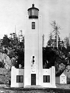 |
Western coast of the mainland on the eastern side of the southern entrance to the Revillagigedo Channel Revillagigedo Channel Revillagigedo Channel is an ocean channel in the Alexander Archipelago of the U.S. state of Alaska. Extending 56 km northwest from the Dixon Entrance, it lies between the mainland to the east, Revillagigedo Island to the north, and Duke Island and Annette Island to the southwest... , about 4.25 miles north of Cape Fox 54°48′10"N 130°56′2"W |
Ketchikan Ketchikan, Alaska Ketchikan is a city in Ketchikan Gateway Borough, Alaska, United States, the southeasternmost sizable city in that state. With an estimated population of 7,368 in 2010 within the city limits, it is the fifth most populous city in the state.... |
||
| 17 | Walker-Broderick House | 541 Pine St. 55°20′40.5"N 131°38′48"W |
Ketchikan Ketchikan, Alaska Ketchikan is a city in Ketchikan Gateway Borough, Alaska, United States, the southeasternmost sizable city in that state. With an estimated population of 7,368 in 2010 within the city limits, it is the fifth most populous city in the state.... |
|||
| 18 | Ziegler House | 623 Grant St. 55°20′40"N 131°38′43"W |
Ketchikan Ketchikan, Alaska Ketchikan is a city in Ketchikan Gateway Borough, Alaska, United States, the southeasternmost sizable city in that state. With an estimated population of 7,368 in 2010 within the city limits, it is the fifth most populous city in the state.... |
See also
- List of National Historic Landmarks in Alaska
- National Register of Historic Places listings in Alaska