

Naguanagua
Encyclopedia
Naguanagua is a city in Carabobo State that forms part of the greater Valencia Metropolitan Area in Venezuela
. It is in the valley of the Cabriales River
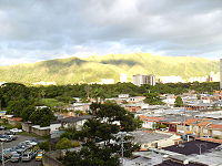
at the base of Cerro El Café and the El Trigal Mountain. Valencia and Naguanagua form a continuous urban area. The highway that runs from the centre of Valencia towards Puerto Cabello
passes through this community; Bolivar Avenue in Valencia becomes University Avenue
in Naguanagua on the northern side of a traffic roundabout, or redoma.
between Valencia and Puerto Cabello. The name of the district/municipio (similar to a county) is Naguanagua, and the main city in the district is Naguanagua. The map at top right shows the municipio in red and the other municipios of Carabobo in gray. Naguanagua was founded as a curacy on 14 May 1782 by the Bishop of Caracas Don Mariano Martí. The name Naguanagua means "Abundance of Waters".
. Also, you can visit La Entrada, a village near Naguanagua where there is the Atanasio Giradot Monument. Between the Sport Square are the "Don Bosco Field" (Campo Don Bosco) in the downtown, the "Simón Bolívar Bicentennial Sport Complex" in La Granja, the "Patinodrome of Capremco" and the "University City Sport Complex" in the Campus Bárbula. Naguanagua has the largest shopping centres Carabobo State including Sambil Centre in Ciudad Jardín Mañongo, La Granja Shopping Centre, Cristal Naguanagua Centre in Las Quintas III Stage and Vía Veneto Shopping Center in Ciudad Jardín Mañongo. Others places include the offices of El Carabobeño newspaper on University Avenue, Los Guayabitos Park, the Botanical Garden of Naguanagua (Salvador Feo La Cruz Avenue), Paseo La Granja Park (Venezuela Avenue), Liberty Park or the Peace Park (Liberty Corner, 10th Street Avenue of Las Quintas, La Granja), Park of Attractions "Dunas" near the first World Trade Centre of Venezuela, "Hosperia Río Convention Center" (Mañongo Road, Mañongo), and the Park of Attractions "Ditto Park" (Tazajal).
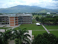 Naguanagua is the home of the main student campus of the University of Carabobo (Spanish:Universidad de Carabobo (UC). The administrative offices are in Valencia proper. The campus is quite large and operates as a separate community with its own security, transportation, and legislative body. Also, there are other universities such as University College of Administration and Trade (Colegio Universitario de Administración y Mercadeo CUAM) near Bárbula Bridge, the National "Open" University (Universidad Nacional Abierta UNA) in El Retobo, the National Polytechnic Research University of the Armed Forces (Universidad Nacional Experimental Politécnica de las Fuerzas Armadas UNEFA) in Las Quintas I stage, and the Bicentennial University of Aragua (Universidad Bicentenaria de Aragua UBA) in La Campiña.
 Road transportation inside the city is provided by the Centre Regional Highway (Autopista Regional del Centro (ARC) and major arterials such as University Avenue, Paseo Cabriales Avenue or Cemetery Avenue, Valencia Avenue, Naguanagua's Bolívar Avenue, Salvador Feo La Cruz Avenue, 190 Avenue, Salvador Allende Avenue (University City Campus Bárbula Universidad de Carabobo).
The current mayor is Alejandro Feo La Cruz.
Venezuela
Venezuela , officially called the Bolivarian Republic of Venezuela , is a tropical country on the northern coast of South America. It borders Colombia to the west, Guyana to the east, and Brazil to the south...
. It is in the valley of the Cabriales River
Cabriales River
The Cabriales River is a river of Venezuela. It drains into Lake Valencia via the Caño Central....
at the base of Cerro El Café and the El Trigal Mountain. Valencia and Naguanagua form a continuous urban area. The highway that runs from the centre of Valencia towards Puerto Cabello
Puerto Cabello
Puerto Cabello is a city on the north coast of Venezuela. It is located in Carabobo State about 75 km west of Caracas. As of 2001, the city has a population of around 154,000 people. The city is the home to the largest port in the country and is thus a vital cog in the country's vast oil...
passes through this community; Bolivar Avenue in Valencia becomes University Avenue
University Avenue
-Canada:*University Avenue *University Avenue *University Avenue *University Avenue *University Avenue *University Street, Montreal-United States:...
in Naguanagua on the northern side of a traffic roundabout, or redoma.
History
Naguanagua was originally founded as a parish districtParish
A parish is a territorial unit historically under the pastoral care and clerical jurisdiction of one parish priest, who might be assisted in his pastoral duties by a curate or curates - also priests but not the parish priest - from a more or less central parish church with its associated organization...
between Valencia and Puerto Cabello. The name of the district/municipio (similar to a county) is Naguanagua, and the main city in the district is Naguanagua. The map at top right shows the municipio in red and the other municipios of Carabobo in gray. Naguanagua was founded as a curacy on 14 May 1782 by the Bishop of Caracas Don Mariano Martí. The name Naguanagua means "Abundance of Waters".
Tourism and Places of interest
Downtown Naguanagua features the Parochial Church of Naguanagua, the Parochial House and Bolívar Square. Near the Carabobo Hospital is the Spaniards Road (Camino de Los Españoles), Colonial Way at the San Esteban National Park (Parque Nacional San Esteban), where one can to go down to San Esteban town near to Puerto CabelloPuerto Cabello
Puerto Cabello is a city on the north coast of Venezuela. It is located in Carabobo State about 75 km west of Caracas. As of 2001, the city has a population of around 154,000 people. The city is the home to the largest port in the country and is thus a vital cog in the country's vast oil...
. Also, you can visit La Entrada, a village near Naguanagua where there is the Atanasio Giradot Monument. Between the Sport Square are the "Don Bosco Field" (Campo Don Bosco) in the downtown, the "Simón Bolívar Bicentennial Sport Complex" in La Granja, the "Patinodrome of Capremco" and the "University City Sport Complex" in the Campus Bárbula. Naguanagua has the largest shopping centres Carabobo State including Sambil Centre in Ciudad Jardín Mañongo, La Granja Shopping Centre, Cristal Naguanagua Centre in Las Quintas III Stage and Vía Veneto Shopping Center in Ciudad Jardín Mañongo. Others places include the offices of El Carabobeño newspaper on University Avenue, Los Guayabitos Park, the Botanical Garden of Naguanagua (Salvador Feo La Cruz Avenue), Paseo La Granja Park (Venezuela Avenue), Liberty Park or the Peace Park (Liberty Corner, 10th Street Avenue of Las Quintas, La Granja), Park of Attractions "Dunas" near the first World Trade Centre of Venezuela, "Hosperia Río Convention Center" (Mañongo Road, Mañongo), and the Park of Attractions "Ditto Park" (Tazajal).
Universities
Roads
Municipal Government
The urban wards and suburbs of Naguanagua are: Naguanagua Downtown (Casquel Historical of the city), Parque Naguanagua, Santa Ana, Nueva Esparta, Güere, Capremco, Tarapio, Las Quintas de Naguanagua (I, II, III ), La Granja, Brisas de Paramacay, Mañongo, Ciudad Jardín Mañongo, Palma Real, La Florida, El Rincón, Tazajal, El Samán, Manantial, Tarapio (Popular neighborhood), La Begoña, La Cidra, La Campiña, El Naranjal, El Pinar, Los Candiles, El Cafetal (I,II), Rotafé, Los Guayabitos, El Guayabal, El Retobo, Sector Puente Bárbula, Santa Eduvigis (Vivienda Rural de Bárbula), Brisas del Café, Mangos Paradise, La Querencia, Agua Linda, Colinas Girardot(I,II,III), Carialinda, Las Palmeras, La Luz, Malagón, Fundación Carabobo, Oncológico, González Plaza.The current mayor is Alejandro Feo La Cruz.