

Måløy Bridge
Encyclopedia
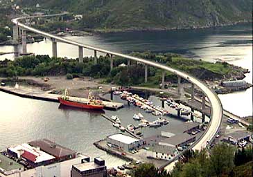
The Måløy Bridge is a cantilever
road bridge in the municipality of Vågsøy
in Sogn og Fjordane
county, Norway
. The bridge connects the village area of Degnepoll
on the mainland and the town of Måløy
on Vågsøy island. The bridge crosses over the Måløystraumen strait
and Måløy island
. The bridge is 1224 metres (4,015.7 ft) long, the longest spans are 125 metres (410.1 ft), and the maximum clearance to the sea is 42 metres (137.8 ft). In total, the bridge has 34 spans.
 Construction started in 1971, and it was officially opened by King Olav V
on 11 July 1974, although the bridge was actually opened for traffic in December of 1973. King Olav came to the opening by ship, returning from a visit to Iceland
. The opening of the bridge had to be postponed for a day because the Royal Yacht
got delayed by bad weather while at sea. The Måløy Bridge was the longest bridge in Norway at the time of its opening. It cost to construct and was a toll bridge
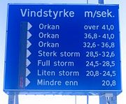
until 1984. The bridge is built to stand wind
up to 75 metres per second (167.8 mph), however vehicles can't stand anything near that. There are boards on each side of the bridge showing the amount of wind, and the bridge has been closed several times because of strong winds.
Cantilever
A cantilever is a beam anchored at only one end. The beam carries the load to the support where it is resisted by moment and shear stress. Cantilever construction allows for overhanging structures without external bracing. Cantilevers can also be constructed with trusses or slabs.This is in...
road bridge in the municipality of Vågsøy
Vågsøy
Vågsøy is a municipality in the county of Sogn og Fjordane, Norway. It is located in the traditional district of Nordfjord. The municipality's administrative center is the town Måløy. Vågsøy is also the name of the main island in the municipality with an area of...
in Sogn og Fjordane
Sogn og Fjordane
is a county in Norway, bordering Møre og Romsdal, Oppland, Buskerud, and Hordaland. The county administration is in the town of Hermansverk in Leikanger municipality while the largest town is Førde....
county, Norway
Norway
Norway , officially the Kingdom of Norway, is a Nordic unitary constitutional monarchy whose territory comprises the western portion of the Scandinavian Peninsula, Jan Mayen, and the Arctic archipelago of Svalbard and Bouvet Island. Norway has a total area of and a population of about 4.9 million...
. The bridge connects the village area of Degnepoll
Degnepoll
Degnepoll or Deknepollen is a village in the municipality of Vågsøy in Sogn og Fjordane county, Norway. Degnepoll is an eastern suburb of the town of Måløy, which it is connected to by a long Måløy Bridge. It is also located about west of the village of Bryggja...
on the mainland and the town of Måløy
Måløy
is a town and the administrative centre of the municipality of Vågsøy in Sogn og Fjordane county, Norway. Måløy is located on the southeastern side of the island of Vågsøy, about northeast of the village of Holvik and about south of Raudeberg. The Måløybrua connects the town to the village of...
on Vågsøy island. The bridge crosses over the Måløystraumen strait
Strait
A strait or straits is a narrow, typically navigable channel of water that connects two larger, navigable bodies of water. It most commonly refers to a channel of water that lies between two land masses, but it may also refer to a navigable channel through a body of water that is otherwise not...
and Måløy island
Moldøen
Moldøen is a small island in the municipality of Vågsøy in Sogn og Fjordane county, Norway. It is located just east of the town of Måløy in the Ulvesund between the large island of Vågsøy and the village of Degnepoll on the mainland...
. The bridge is 1224 metres (4,015.7 ft) long, the longest spans are 125 metres (410.1 ft), and the maximum clearance to the sea is 42 metres (137.8 ft). In total, the bridge has 34 spans.
Olav V of Norway
Olav V was the king of Norway from 1957 until his death. A member of the House of Schleswig-Holstein-Sonderburg-Glücksburg, Olav was born in the United Kingdom as the son of King Haakon VII of Norway and Queen Maud of Norway...
on 11 July 1974, although the bridge was actually opened for traffic in December of 1973. King Olav came to the opening by ship, returning from a visit to Iceland
Iceland
Iceland , described as the Republic of Iceland, is a Nordic and European island country in the North Atlantic Ocean, on the Mid-Atlantic Ridge. Iceland also refers to the main island of the country, which contains almost all the population and almost all the land area. The country has a population...
. The opening of the bridge had to be postponed for a day because the Royal Yacht
Royal Yacht
A royal yacht is a ship used by a monarch or a royal family. If the monarch is an emperor the proper term is imperial yacht. Most of them are financed by the government of the country of which the monarch is head...
got delayed by bad weather while at sea. The Måløy Bridge was the longest bridge in Norway at the time of its opening. It cost to construct and was a toll bridge
Toll bridge
A toll bridge is a bridge over which traffic may pass upon payment of a toll, or fee.- History :The practice of collecting tolls on bridges probably harks back to the days of ferry crossings where people paid a fee to be ferried across stretches of water. As boats became impractical to carry large...
until 1984. The bridge is built to stand wind
Wind
Wind is the flow of gases on a large scale. On Earth, wind consists of the bulk movement of air. In outer space, solar wind is the movement of gases or charged particles from the sun through space, while planetary wind is the outgassing of light chemical elements from a planet's atmosphere into space...
up to 75 metres per second (167.8 mph), however vehicles can't stand anything near that. There are boards on each side of the bridge showing the amount of wind, and the bridge has been closed several times because of strong winds.
See also
- List of bridges in Norway
- List of bridges in Norway by length
- List of bridges
- List of bridges by length