
Vågsøy
Encyclopedia
Vågsøy is a municipality
in the county
of Sogn og Fjordane
, Norway
. It is located in the traditional district
of Nordfjord
. The municipality's administrative center is the town Måløy
. Vågsøy is also the name of the main island in the municipality with an area of 64 square kilometres (24.7 sq mi). Other villages in Vågsøy include: Bryggja
, Degnepoll
, Holvik, Kvalheim
, Langenes
, Raudeberg
, Refvik
, Silda
, Tennebø
, Totland, Vedvik
, and Vågsvåg
.
The municipality of Vågsøy is the second largest fishing municipality in Norway
, and is home to one of Norway's most modern fish-processing plants.
parish
(prestegjeld
), was divided into two sub-parishes: Nord-Vågsøy
and Sør-Vågsøy
within the municipality of Selje
. This divided Selje into three parts. Then, on 1 January 1910, the municipality of Selje
was split into three separate municipalities: Nord-Vågsøy
(population: 1,111); Sør-Vågsøy
(population: 1,517); and Selje (population: 3,367).
On 1 January 1964, the new municipality of Vågsøy was created by merging the following areas together:
The new municipality had an initial population of 6,962.
form of the name was Vágsøy. The first element is the genitive case of vágr which means "bay
" and the last element is øy which means "island".
of Vågsøy is of modern design. The arms were granted on 27 March 1987. The arms show two rudder
s, used in the one-man boats which have been used for a long time in the village. The rudders are silver and the background is blue.
has three churches within the municipality of Vågsøy. It is part of the Diocese of Bjørgvin
and the Rural Deanery
(Prosti) of Nordfjord
.
(through 10th grade), outpatient health services
, senior citizen
services, unemployment
and other social services
, zoning
, economic development
, and municipal road
s. The municipality is governed by a municipal council of elected representatives, which in turn elect a mayor
.
breakdown is as follows:
(ordførar) of a municipality in Norway is a representative of the majority party of the municipal council who is elected to lead the council. Roger Bernt Silden of the Labour Party
(Det Norske Arbeiderpartiet) was re-elected mayor for the 2007–2011 term.
In 2007, Vågsøy participated in a trial where the mayor was directly elected. The sitting mayor, Roger B. Silden, received 44.1% of the votes and won the election. His party (the Norwegian Labour Party
), however, did poorer than in 2003 and it became the second largest party with only 21.8% of the votes.
. The municipality is named after its largest island. The lake Degnepollvatnet
is located between the villages of Degnepoll
and Tennebø
.
The municipalities of Selje
(in Sogn og Fjordane
county) and Vanylven
(in Møre og Romsdal
county) border to the north, the municipality of Eid
lies to the east, the municipality of Bremanger
lies to the south, and the North Sea
borders Vågsøy to the west.
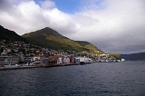
attained city status in 2004. It lies by the Ulvesundet sound on the island of Vågsøy, and is joined to the mainland by the 1224 metres (4,015.7 ft) long Måløy Bridge
, an impressive structure that forms a majestic gateway for all sea-going traffic. The Coastal Steamer (Hurtigruten
) has daily departures. The old part of the city lies on the island, Moldøen
.
came to Vågsberget to open a trading business. There was probably trading activity and an inn before Fester’s arrival, and the trading post at Vågsberget has changed hands several times throughout the years. Restoration work is being carried out on Vågsberget, but the café and exhibition is open in summer and guided tours are available. There is also an exhibition featuring old fishing boats and equipment.
, the island in Sildagapet bay, is an old fishing community, which in its heyday had a population of 150 who made a living from fishing and farming. Its current winter population is only about 30, while in summer it is host to several hundred people, staying in holiday houses and cabins. The island has a very special restaurant perched on a rock out in the southern harbor. There are also cabins for rent there. The impressive jetty in Silda’s northern harbor was started in the 1860s and completed in the 20th century. With the exception of a few tractors, the island is "car free", but it has good cycling and walking tracks, footpaths and excellent walking terrain. A regular boat service runs to and from Måløy several times a day.
s. They are situated far out on steep crags with the foaming sea as their nearest neighbour. Three of them are open daily and are available for let for short or long periods.
´s finest swimming beaches. Refvik
is approximately 10 kilometres (6.2 mi) from Måløy.
Municipalities of Norway
Norway is divided into 19 administrative regions, called counties , and 430 municipalities...
in the county
Counties of Norway
Norway is divided into 19 administrative regions, called counties . The counties form the primary first-level subdivisions of Norway and are further divided into 430 municipalities...
of Sogn og Fjordane
Sogn og Fjordane
is a county in Norway, bordering Møre og Romsdal, Oppland, Buskerud, and Hordaland. The county administration is in the town of Hermansverk in Leikanger municipality while the largest town is Førde....
, Norway
Norway
Norway , officially the Kingdom of Norway, is a Nordic unitary constitutional monarchy whose territory comprises the western portion of the Scandinavian Peninsula, Jan Mayen, and the Arctic archipelago of Svalbard and Bouvet Island. Norway has a total area of and a population of about 4.9 million...
. It is located in the traditional district
Districts of Norway
The country Norway is historically divided into a number of districts. Many districts have deep historical roots, and only partially coincide with today's administrative units of counties and municipalities. The districts are defined by geographical features, often valleys, mountain ranges, fjords,...
of Nordfjord
Nordfjord
Nordfjord is a fjord and a traditional district in the northern part of Sogn og Fjordane county in Western Norway. The district comprises the municipalities of Selje, Vågsøy, Bremanger, Eid, Gloppen, Hornindal, and Stryn. Nordfjord covers an area of and is home to a population of approximately...
. The municipality's administrative center is the town Måløy
Måløy
is a town and the administrative centre of the municipality of Vågsøy in Sogn og Fjordane county, Norway. Måløy is located on the southeastern side of the island of Vågsøy, about northeast of the village of Holvik and about south of Raudeberg. The Måløybrua connects the town to the village of...
. Vågsøy is also the name of the main island in the municipality with an area of 64 square kilometres (24.7 sq mi). Other villages in Vågsøy include: Bryggja
Bryggja
Bryggja is a village in eastern part of the municipality of Vågsøy in Sogn og Fjordane county, Norway. It is located along the north shore of the Nordfjord. The village is located about east of the urban area of Degnepoll–Tennebø–Måløy in Vågsøy and it is about west of Stårheim in...
, Degnepoll
Degnepoll
Degnepoll or Deknepollen is a village in the municipality of Vågsøy in Sogn og Fjordane county, Norway. Degnepoll is an eastern suburb of the town of Måløy, which it is connected to by a long Måløy Bridge. It is also located about west of the village of Bryggja...
, Holvik, Kvalheim
Kvalheim
Kvalheim is a coastal village with large agricultural areas in the municipality of Vågsøy in Sogn og Fjordane county, Norway. The village is located on the western side of the island of Vågsøy, about west of Raudeberg. The neighboring villages of Refvik, Vedvik, and Langenes are located across...
, Langenes
Langenes, Sogn og Fjordane
Langenes or Langeneset is a village in the municipality of Vågsøy in Sogn og Fjordane county, Norway. It is located on the northeastern side of the island of Vågsøy on the shore of the Sildegapet bay. It is about east of the villages of Vedvik and Refvik. The larger village of Raudeberg is...
, Raudeberg
Raudeberg
Raudeberg is a village in the municipality of Vågsøy in Sogn og Fjordane county, Norway. It is located on the east side of the island of Vågsøy, near the Nord-Vågsøy church. The villages of Refvik, Vedvik, and Langenes are located a few kilometers to the north, and the town of Måløy is about to...
, Refvik
Refvik
Refvik or Refvika is a village in the municipality of Vågsøy in Sogn og Fjordane county, Norway. It is located on the north side of the island of Vågsøy, about northwest of Raudeberg, south of Vedvik, and southwest of Langenes...
, Silda
Silda
Silda is an island in the municipality of Vågsøy in Sogn og Fjordane county, Norway. It is located northeast of the island of Vågsøy in the Sildagapet bay, about east of the small village of Langenes or about northeast of Raudeberg. This is the site of the 1810 Battle of Silda...
, Tennebø
Tennebø
Tennebø is a village in the municipality of Vågsøy in Sogn og Fjordane county, Norway. It is located about southeast of Degnepoll and about from the municipal center of Måløy. The lake Degnepollvatnet is just north of the village of Tennebø...
, Totland, Vedvik
Vedvik
Vedvik or Vedvika is a village in the municipality of Vågsøy in Sogn og Fjordane county, Norway. The village is located on the north side of the island of Vågsøy, about northeast of Refvik, west of Langenes, and about north of Raudeberg...
, and Vågsvåg
Vågsvåg
Vågsvåg is a village in the municipality of Vågsøy in Sogn og Fjordane county, Norway. It is located on the southern part of the island of Vågsøy along the Vågsfjord. It is located about northwest of the village of Holvik, and about west of the town of Måløy.The population of Vågsvåg was 214,...
.
The municipality of Vågsøy is the second largest fishing municipality in Norway
Norway
Norway , officially the Kingdom of Norway, is a Nordic unitary constitutional monarchy whose territory comprises the western portion of the Scandinavian Peninsula, Jan Mayen, and the Arctic archipelago of Svalbard and Bouvet Island. Norway has a total area of and a population of about 4.9 million...
, and is home to one of Norway's most modern fish-processing plants.
General information
In 1906, the sub-parish (sokn) of Vågsøy, then part of the SeljeSelje
Selje is a municipality in the county of Sogn og Fjordane, Norway. It is located in the traditional district of Nordfjord. The village of Selje is the administrative center of Selje municipality...
parish
Church of Norway
The Church of Norway is the state church of Norway, established after the Lutheran reformation in Denmark-Norway in 1536-1537 broke the ties to the Holy See. The church confesses the Lutheran Christian faith...
(prestegjeld
Prestegjeld
A Prestegjeld is a geographic and administrative area of the Church of Norway roughly equivalent to a parish. A prestegjeld can consist of one or many congregations...
), was divided into two sub-parishes: Nord-Vågsøy
Nord-Vågsøy
Nord-Vågsøy is a former municipality in Sogn og Fjordane county, Norway. It is located in the northern part of the present-day municipality of Vågsøy...
and Sør-Vågsøy
Sør-Vågsøy
Sør-Vågsøy is a former municipality in Sogn og Fjordane county in Norway. It is located in the southern part of the present-day municipality of Vågsøy...
within the municipality of Selje
Selje
Selje is a municipality in the county of Sogn og Fjordane, Norway. It is located in the traditional district of Nordfjord. The village of Selje is the administrative center of Selje municipality...
. This divided Selje into three parts. Then, on 1 January 1910, the municipality of Selje
Selje
Selje is a municipality in the county of Sogn og Fjordane, Norway. It is located in the traditional district of Nordfjord. The village of Selje is the administrative center of Selje municipality...
was split into three separate municipalities: Nord-Vågsøy
Nord-Vågsøy
Nord-Vågsøy is a former municipality in Sogn og Fjordane county, Norway. It is located in the northern part of the present-day municipality of Vågsøy...
(population: 1,111); Sør-Vågsøy
Sør-Vågsøy
Sør-Vågsøy is a former municipality in Sogn og Fjordane county in Norway. It is located in the southern part of the present-day municipality of Vågsøy...
(population: 1,517); and Selje (population: 3,367).
On 1 January 1964, the new municipality of Vågsøy was created by merging the following areas together:
- Nord-VågsøyNord-VågsøyNord-Vågsøy is a former municipality in Sogn og Fjordane county, Norway. It is located in the northern part of the present-day municipality of Vågsøy...
municipality (population: 1,476) - Sør-VågsøySør-VågsøySør-Vågsøy is a former municipality in Sogn og Fjordane county in Norway. It is located in the southern part of the present-day municipality of Vågsøy...
municipality (population: 3,926) - from SeljeSeljeSelje is a municipality in the county of Sogn og Fjordane, Norway. It is located in the traditional district of Nordfjord. The village of Selje is the administrative center of Selje municipality...
: the island of SildaSildaSilda is an island in the municipality of Vågsøy in Sogn og Fjordane county, Norway. It is located northeast of the island of Vågsøy in the Sildagapet bay, about east of the small village of Langenes or about northeast of Raudeberg. This is the site of the 1810 Battle of Silda...
, the Hagevik-Osmundsvåg area, and Sørpoll (population: 344) - from DavikDavikDavik is a village and former municipality in the traditional district of Nordfjord in Sogn og Fjordane county, Norway. The former municipality of Davik was located in parts of the present-day municipalities of Vågsøy, Bremanger, and Eid. The administrative center of the former municipality was...
: the islands of Husevågøy, Grindøy, Gangsøy, and Risøy; and all of Davik that was north of the NordfjordNordfjordNordfjord is a fjord and a traditional district in the northern part of Sogn og Fjordane county in Western Norway. The district comprises the municipalities of Selje, Vågsøy, Bremanger, Eid, Gloppen, Hornindal, and Stryn. Nordfjord covers an area of and is home to a population of approximately...
and west of Lefdal (population: 1,216)
The new municipality had an initial population of 6,962.
Name
The Old NorseOld Norse
Old Norse is a North Germanic language that was spoken by inhabitants of Scandinavia and inhabitants of their overseas settlements during the Viking Age, until about 1300....
form of the name was Vágsøy. The first element is the genitive case of vágr which means "bay
Headlands and bays
Headlands and bays are two related features of the coastal environment.- Geology and geography :Headlands and bays are often found on the same coastline. A bay is surrounded by land on three sides, whereas a headland is surrounded by water on three sides. Headlands are characterized by high,...
" and the last element is øy which means "island".
Coat-of-arms
The coat-of-armsCoat of arms
A coat of arms is a unique heraldic design on a shield or escutcheon or on a surcoat or tabard used to cover and protect armour and to identify the wearer. Thus the term is often stated as "coat-armour", because it was anciently displayed on the front of a coat of cloth...
of Vågsøy is of modern design. The arms were granted on 27 March 1987. The arms show two rudder
Rudder
A rudder is a device used to steer a ship, boat, submarine, hovercraft, aircraft or other conveyance that moves through a medium . On an aircraft the rudder is used primarily to counter adverse yaw and p-factor and is not the primary control used to turn the airplane...
s, used in the one-man boats which have been used for a long time in the village. The rudders are silver and the background is blue.
Churches
The Church of NorwayChurch of Norway
The Church of Norway is the state church of Norway, established after the Lutheran reformation in Denmark-Norway in 1536-1537 broke the ties to the Holy See. The church confesses the Lutheran Christian faith...
has three churches within the municipality of Vågsøy. It is part of the Diocese of Bjørgvin
Diocese of Bjørgvin
Bjørgvin Diocese is a diocese in the Church of Norway. It covers churches located in the counties of Hordaland and Sogn og Fjordane. The cathedral city is Bergen. Bergen Cathedral, formerly the Church of Saint Olaf, serves as the seat of the presiding Bishop...
and the Rural Deanery
Deanery
A Deanery is an ecclesiastical entity in both the Roman Catholic Church and the Church of England. A deanery is either the jurisdiction or residence of a Dean.- Catholic usage :...
(Prosti) of Nordfjord
Nordfjord
Nordfjord is a fjord and a traditional district in the northern part of Sogn og Fjordane county in Western Norway. The district comprises the municipalities of Selje, Vågsøy, Bremanger, Eid, Gloppen, Hornindal, and Stryn. Nordfjord covers an area of and is home to a population of approximately...
.
| Parish (Prestegjeld) | Sub-Parish (Sogn) | Church Name | Year Built | Location of the Church |
|---|---|---|---|---|
| Vågsøy Parish | Vågsøy | Nord-Vågsøy kyrkje | 1960 | Raudeberg Raudeberg Raudeberg is a village in the municipality of Vågsøy in Sogn og Fjordane county, Norway. It is located on the east side of the island of Vågsøy, near the Nord-Vågsøy church. The villages of Refvik, Vedvik, and Langenes are located a few kilometers to the north, and the town of Måløy is about to... |
| Sør-Vågsøy kyrkje | 1907 | Måløy Måløy is a town and the administrative centre of the municipality of Vågsøy in Sogn og Fjordane county, Norway. Måløy is located on the southeastern side of the island of Vågsøy, about northeast of the village of Holvik and about south of Raudeberg. The Måløybrua connects the town to the village of... |
||
| Totland kyrkje | 1912 | Totland Totland Totland is a village and civil parish at the western tip of the Isle of Wight. It lies on the coast at Colwell Bay, which is the closest part of the island to the British mainland... |
||
| *The 3 sogns were merged into 1 sogn in 2001. Sør-Vågsøy kyrkje is the main parish church. |
||||
Government
All municipalities in Norway, including Vågsøy, are responsible for primary educationPrimary education
A primary school is an institution in which children receive the first stage of compulsory education known as primary or elementary education. Primary school is the preferred term in the United Kingdom and many Commonwealth Nations, and in most publications of the United Nations Educational,...
(through 10th grade), outpatient health services
Health care
Health care is the diagnosis, treatment, and prevention of disease, illness, injury, and other physical and mental impairments in humans. Health care is delivered by practitioners in medicine, chiropractic, dentistry, nursing, pharmacy, allied health, and other care providers...
, senior citizen
Old age
Old age consists of ages nearing or surpassing the average life span of human beings, and thus the end of the human life cycle...
services, unemployment
Unemployment
Unemployment , as defined by the International Labour Organization, occurs when people are without jobs and they have actively sought work within the past four weeks...
and other social services
Social work
Social Work is a professional and academic discipline that seeks to improve the quality of life and wellbeing of an individual, group, or community by intervening through research, policy, community organizing, direct practice, and teaching on behalf of those afflicted with poverty or any real or...
, zoning
Zoning
Zoning is a device of land use planning used by local governments in most developed countries. The word is derived from the practice of designating permitted uses of land based on mapped zones which separate one set of land uses from another...
, economic development
Economic development
Economic development generally refers to the sustained, concerted actions of policymakers and communities that promote the standard of living and economic health of a specific area...
, and municipal road
Road
A road is a thoroughfare, route, or way on land between two places, which typically has been paved or otherwise improved to allow travel by some conveyance, including a horse, cart, or motor vehicle. Roads consist of one, or sometimes two, roadways each with one or more lanes and also any...
s. The municipality is governed by a municipal council of elected representatives, which in turn elect a mayor
Mayor
In many countries, a Mayor is the highest ranking officer in the municipal government of a town or a large urban city....
.
Municipal council
The municipal council (Kommunestyre) of Vågsøy is made up of 26 representatives that are elected to every four years. For 2007–2011, the partyPolitical party
A political party is a political organization that typically seeks to influence government policy, usually by nominating their own candidates and trying to seat them in political office. Parties participate in electoral campaigns, educational outreach or protest actions...
breakdown is as follows:
Mayor
The mayorMayor
In many countries, a Mayor is the highest ranking officer in the municipal government of a town or a large urban city....
(ordførar) of a municipality in Norway is a representative of the majority party of the municipal council who is elected to lead the council. Roger Bernt Silden of the Labour Party
Norwegian Labour Party
The Labour Party is a social-democratic political party in Norway. It is the senior partner in the current Norwegian government as part of the Red-Green Coalition, and its leader, Jens Stoltenberg, is the current Prime Minister of Norway....
(Det Norske Arbeiderpartiet) was re-elected mayor for the 2007–2011 term.
In 2007, Vågsøy participated in a trial where the mayor was directly elected. The sitting mayor, Roger B. Silden, received 44.1% of the votes and won the election. His party (the Norwegian Labour Party
Norwegian Labour Party
The Labour Party is a social-democratic political party in Norway. It is the senior partner in the current Norwegian government as part of the Red-Green Coalition, and its leader, Jens Stoltenberg, is the current Prime Minister of Norway....
), however, did poorer than in 2003 and it became the second largest party with only 21.8% of the votes.
Geography
Vågsøy is made up of the mainland and islands on the northern and outer shore of the NordfjordNordfjord
Nordfjord is a fjord and a traditional district in the northern part of Sogn og Fjordane county in Western Norway. The district comprises the municipalities of Selje, Vågsøy, Bremanger, Eid, Gloppen, Hornindal, and Stryn. Nordfjord covers an area of and is home to a population of approximately...
. The municipality is named after its largest island. The lake Degnepollvatnet
Degnepollvatnet
Degnepollvatnet or Deknepollvatnet, known locally as Polljavatnet, is a lake in the municipality of Vågsøy in Sogn og Fjordane county, Norway. The lake is situated between the small villages of Degnepoll and Tennebø, just from the town of Måløy....
is located between the villages of Degnepoll
Degnepoll
Degnepoll or Deknepollen is a village in the municipality of Vågsøy in Sogn og Fjordane county, Norway. Degnepoll is an eastern suburb of the town of Måløy, which it is connected to by a long Måløy Bridge. It is also located about west of the village of Bryggja...
and Tennebø
Tennebø
Tennebø is a village in the municipality of Vågsøy in Sogn og Fjordane county, Norway. It is located about southeast of Degnepoll and about from the municipal center of Måløy. The lake Degnepollvatnet is just north of the village of Tennebø...
.
The municipalities of Selje
Selje
Selje is a municipality in the county of Sogn og Fjordane, Norway. It is located in the traditional district of Nordfjord. The village of Selje is the administrative center of Selje municipality...
(in Sogn og Fjordane
Sogn og Fjordane
is a county in Norway, bordering Møre og Romsdal, Oppland, Buskerud, and Hordaland. The county administration is in the town of Hermansverk in Leikanger municipality while the largest town is Førde....
county) and Vanylven
Vanylven
Vanylven is a municipality in Møre og Romsdal county, Norway. It is part of the Sunnmøre region. The administrative centre is Fiskåbygd. Other villages include Syvde, Rovdane, and Myklebost.-General information:...
(in Møre og Romsdal
Møre og Romsdal
is a county in the northernmost part of Western Norway. It borders the counties of Sør-Trøndelag, Oppland and Sogn og Fjordane. The county administration is located in Molde, while Ålesund is the largest city.-The name:...
county) border to the north, the municipality of Eid
Eid, Norway
Eid is a municipality in the county of Sogn og Fjordane, Norway. It is located in the traditional district of Nordfjord. The village of Nordfjordeid is the administrative center of the municipality. Other larger villages are Mogrenda, Stårheim, Haugen, Kjølsdalen, Heggjabygda, and LoteEid is...
lies to the east, the municipality of Bremanger
Bremanger
Bremanger is a municipality in the county of Sogn og Fjordane, Norway. Bremanger is the only municipality in Sogn og Fjordane, which is located in two districts. The north-eastern parts comprising Oldeide, Berle, Rugsund, Davik, Isane and Ålfoten is located in Nordfjord, while Bremanger, Kalvåg,...
lies to the south, and the North Sea
North Sea
In the southwest, beyond the Straits of Dover, the North Sea becomes the English Channel connecting to the Atlantic Ocean. In the east, it connects to the Baltic Sea via the Skagerrak and Kattegat, narrow straits that separate Denmark from Norway and Sweden respectively...
borders Vågsøy to the west.
Måløy
MåløyMåløy
is a town and the administrative centre of the municipality of Vågsøy in Sogn og Fjordane county, Norway. Måløy is located on the southeastern side of the island of Vågsøy, about northeast of the village of Holvik and about south of Raudeberg. The Måløybrua connects the town to the village of...
attained city status in 2004. It lies by the Ulvesundet sound on the island of Vågsøy, and is joined to the mainland by the 1224 metres (4,015.7 ft) long Måløy Bridge
Måløy Bridge
The Måløy Bridge is a cantilever road bridge in the municipality of Vågsøy in Sogn og Fjordane county, Norway. The bridge connects the village area of Degnepoll on the mainland and the town of Måløy on Vågsøy island. The bridge crosses over the Måløystraumen strait and Måløy island. The bridge...
, an impressive structure that forms a majestic gateway for all sea-going traffic. The Coastal Steamer (Hurtigruten
Hurtigruten
Hurtigruten or Hurtigruta is a Norwegian passenger and freight line with daily sailings along Norway's western and northern coast. Sometimes referred to in English as Norwegian Coastal Express, Hurtigruten ships sail almost the entire length of the country, completing the roundtrip journey in 11...
) has daily departures. The old part of the city lies on the island, Moldøen
Moldøen
Moldøen is a small island in the municipality of Vågsøy in Sogn og Fjordane county, Norway. It is located just east of the town of Måløy in the Ulvesund between the large island of Vågsøy and the village of Degnepoll on the mainland...
.
Kannestein
Over thousands of years, ocean waves have ground the rock to the special shape it has today. You find it in the village of Oppedal, approximately 10 kilometres (6.2 mi) west of the center of Måløy. Every year many visitors come to Oppedal to take a closer look at the stone. The Kannestein or Kanne Stone was formed by loose stones and the pounding of the waves over a period of thousands of years, and stands today as a 4 to 5 m (13.1 to 16.4 ) high, narrow-footed rock. This is caused by stones having split loose, which have knocked and gnawed at the rockface until they have become polished and rounded. Loose stones have then worked themselves deeper into the rock. New stones have come, and in time the potholes have become deeper and wider. Several potholes near to each other have been polished for so long that the sides have been rubbed away, leaving just the middle section, such as the Kanne Stone.Vågsberget trading post
In 1636, trader Didrik Fester from BergenBergen
Bergen is the second largest city in Norway with a population of as of , . Bergen is the administrative centre of Hordaland county. Greater Bergen or Bergen Metropolitan Area as defined by Statistics Norway, has a population of as of , ....
came to Vågsberget to open a trading business. There was probably trading activity and an inn before Fester’s arrival, and the trading post at Vågsberget has changed hands several times throughout the years. Restoration work is being carried out on Vågsberget, but the café and exhibition is open in summer and guided tours are available. There is also an exhibition featuring old fishing boats and equipment.
Silda
SildaSilda
Silda is an island in the municipality of Vågsøy in Sogn og Fjordane county, Norway. It is located northeast of the island of Vågsøy in the Sildagapet bay, about east of the small village of Langenes or about northeast of Raudeberg. This is the site of the 1810 Battle of Silda...
, the island in Sildagapet bay, is an old fishing community, which in its heyday had a population of 150 who made a living from fishing and farming. Its current winter population is only about 30, while in summer it is host to several hundred people, staying in holiday houses and cabins. The island has a very special restaurant perched on a rock out in the southern harbor. There are also cabins for rent there. The impressive jetty in Silda’s northern harbor was started in the 1860s and completed in the 20th century. With the exception of a few tractors, the island is "car free", but it has good cycling and walking tracks, footpaths and excellent walking terrain. A regular boat service runs to and from Måløy several times a day.
Lighthouses
Vågsøy municipality has four impressive lighthouseLighthouse
A lighthouse is a tower, building, or other type of structure designed to emit light from a system of lamps and lenses or, in older times, from a fire, and used as an aid to navigation for maritime pilots at sea or on inland waterways....
s. They are situated far out on steep crags with the foaming sea as their nearest neighbour. Three of them are open daily and are available for let for short or long periods.
- Kråkenes FyrKråkenes LighthouseKråkenes Lighthouse is a coastal lighthouse in the municipality of Vågsøy in Sogn og Fjordane, Norway. It was established in 1906, and automated in 1986....
is a working lighthouse and also a weather station that collects important information. Kråkenes lighthouse, which offers great views of the ocean at StadhavetStad (peninsula)Stad or Stadlandet is a peninsula in the municipality of Selje in Sogn og Fjordane county, Norway.The name is sometimes also written as Stadt, Statt or Stadlandet–not to be confused with the similar German word Stadt. The d in Stad is pronounced in Norwegian as a t. The Stad peninsula has a...
, lies at the most northerly point on the island of Vågsøy and is accessible by road. When the weather is stormy it is a tremendous experience to stand at a safe distance from the foaming waves studying the frenzied ocean.
- Skognsnes Fyr is an automatic lighthouse with no road access. It is a one hour walk from Halsør in easy hiking terrain. There are also beautiful views towards Stadhavet. Ytre Nordfjord Turlag runs this lighthouse and offers overnight accommodation and day visits.
- Hendanes Fyr is an automatic lighthouse on the west side of the Torskanger inlet. It is located a short walk from the road and offers beautiful views of Stadhavet and Klovningen.
- Ulvesund Fyr is a lighthouse located south of Stad, 10 kilometres (6.2 mi) from Måløy in outer NordfjordNordfjordNordfjord is a fjord and a traditional district in the northern part of Sogn og Fjordane county in Western Norway. The district comprises the municipalities of Selje, Vågsøy, Bremanger, Eid, Gloppen, Hornindal, and Stryn. Nordfjord covers an area of and is home to a population of approximately...
. It was built in 1870, and was run by manpower until 1985 when it was turned automatic.
Beaches
Refviksanden Beach, with its beautiful silver sand, is a 1.5 kilometre (0.93205910497471 mi) long beach that is one of NorwayNorway
Norway , officially the Kingdom of Norway, is a Nordic unitary constitutional monarchy whose territory comprises the western portion of the Scandinavian Peninsula, Jan Mayen, and the Arctic archipelago of Svalbard and Bouvet Island. Norway has a total area of and a population of about 4.9 million...
´s finest swimming beaches. Refvik
Refvik
Refvik or Refvika is a village in the municipality of Vågsøy in Sogn og Fjordane county, Norway. It is located on the north side of the island of Vågsøy, about northwest of Raudeberg, south of Vedvik, and southwest of Langenes...
is approximately 10 kilometres (6.2 mi) from Måløy.