
Mt. Conness
Encyclopedia
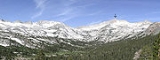
Mount Conness is a mountain in the Sierra Nevada range, to the west of the Hall Natural Area
. Conness is on the boundary between the Inyo National Forest
and Yosemite National Park
. The Conness Glacier
lies north of the summit.
 Mount Conness is named for John Conness
(1821–1909), a native of Ireland who came to United States in 1833.
Conness was a member of California legislature (1853–1854, 1860–1861) and the United States Senator from California (1863–1869). He resided in Massachusetts from 1869 until his death in 1909.
In 1860 Josiah Dwight Whitney, Jr.
was appointed State Geologist of California and he organized the California Geological Survey
(1863–1870). Whitney, along with William H. Brewer, Clarence King
, James T. Gardiner
, Charles F. Hoffmann
, Lorenzo G. Yates, Richard D. Cotter and others, made an extensive survey of California, including the Sierra Nevada and Yosemite region. Whitney wrote:
Clarence King, a geologist for the Survey and the first to ascend Mount Conness along with James T. Gardiner in 1864, wrote:
The members of the Whitney Survey were naturally appreciative of Senator Conness for helping their cause.
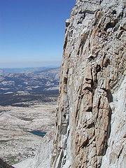
and begin the climb at dawn. It takes about a full day to summit.
The summit block consists of class 2 scrambling along a knife edge ridge leading to the summit consisting of spectacular views to the east of the Conness Glacier
and to the west toward Tuolumne Meadows
.
Hall Natural Area
The Hall Natural Area or Harvey Monroe Hall Natural Area is a region on the eastern border of Yosemite National Park in California. The area is located about 1.25 miles northwest of Tioga Pass, and is approximately four miles long from north to south and 2.75 miles wide at its widest point...
. Conness is on the boundary between the Inyo National Forest
Inyo National Forest
Inyo National Forest is a federally administered forest in the United States. The forest covers parts of the eastern Sierra Nevada of California, and the White Mountains of California and Nevada. It contains two wilderness areas: the John Muir Wilderness and the Ansel Adams Wilderness...
and Yosemite National Park
Yosemite National Park
Yosemite National Park is a United States National Park spanning eastern portions of Tuolumne, Mariposa and Madera counties in east central California, United States. The park covers an area of and reaches across the western slopes of the Sierra Nevada mountain chain...
. The Conness Glacier
Conness Glacier
The Conness Glacier is a glacier located on the steep northeast cirque on Mount Conness, east of the Sierra Nevada crest. The glacier is situated at about 11,500 feet and can be seen from Saddlebag Lake to the east. The glacier is the largest glacier in the Sierra Nevada north of Tioga Pass or...
lies north of the summit.
History
John Conness
John Conness was a first-generation Irish-American businessman who served as a U.S. Senator from California during the American Civil War and the early years of Reconstruction. He introduced a bill to establish Yosemite National Park and voted to abolish slavery...
(1821–1909), a native of Ireland who came to United States in 1833.
Conness was a member of California legislature (1853–1854, 1860–1861) and the United States Senator from California (1863–1869). He resided in Massachusetts from 1869 until his death in 1909.
In 1860 Josiah Dwight Whitney, Jr.
Josiah Whitney
Josiah Dwight Whitney was an American geologist, professor of geology at Harvard University , and chief of the California Geological Survey...
was appointed State Geologist of California and he organized the California Geological Survey
California Geological Survey
Although it was not until 1880 that the California State Mining Bureau, predecessor to the California Geological Survey, was established, the "roots" of California's state geological survey date to an earlier time...
(1863–1870). Whitney, along with William H. Brewer, Clarence King
Clarence King
Clarence R. King was an American geologist, mountaineer, and art critic. First director of the United States Geological Survey, from 1879 to 1881, King was noted for his exploration of the Sierra Nevada. He was born in Newport, Rhode Island.-Career:...
, James T. Gardiner
James Terry Gardiner
James Terry Gardiner was an American surveyor and engineer.Gardiner was born in Troy, New York, the son of Daniel Gardiner and Ann Terry Gardiner. He briefly attended Rensselaer Polytechnic Institute and the Sheffield Scientific School. In 1863 he traveled on horseback to California with his...
, Charles F. Hoffmann
Charles F. Hoffmann
Charles Frederick Hoffmann was a German-American topographer working in California U.S. from 1860 to 1880.-Life:Hoffmann was born in Frankfurt, Germany, 1838. After receiving an education in engineering, he emigrated to America. In 1857 he was topographer for Frederick Lander’s survey to the Rocky...
, Lorenzo G. Yates, Richard D. Cotter and others, made an extensive survey of California, including the Sierra Nevada and Yosemite region. Whitney wrote:
"Mount Conness bears the name of a distinguished citizen of California, now a United States Senator, who deserves more than any other person, the credit of carrying the bill, organizing the Geological Survey of California, through the Legislature, and who is chiefly to be credited for another great scientific work, the Survey of the 40th ParallelGeological Exploration of the Fortieth ParallelThe Geological Exploration of the Fortieth Parallel was a geological survey made by order of the Secretary of War according to acts of Congress of March 2,1867, and March 3, 1869, under the direction of Brig. and Bvt. Major General A. A. Humphreys, Chief of Engineers, by Clarence King, U. S....
."
Clarence King, a geologist for the Survey and the first to ascend Mount Conness along with James T. Gardiner in 1864, wrote:
"I recognized the old familiar summit... and that firm peak with titan strength and brow so square and solid, it seems altogether natural we should have named it for California’s statesman, John Conness."
The members of the Whitney Survey were naturally appreciative of Senator Conness for helping their cause.
Climbing
Conness is a training ground for alpine climbing since it utilizes all aspects of mountaineering: trails, scrambling, and glacier trekking; all at a high altitude for California. Usually climbers camp near Tioga PassTioga Pass
Tioga Pass is a mountain pass in the Sierra Nevada mountains of California. State Route 120 runs through it, and serves as the eastern entry point for Yosemite National Park. It is the highest highway pass in California and in the Sierra Nevada. Mount Dana is to the east of the pass...
and begin the climb at dawn. It takes about a full day to summit.
The summit block consists of class 2 scrambling along a knife edge ridge leading to the summit consisting of spectacular views to the east of the Conness Glacier
Conness Glacier
The Conness Glacier is a glacier located on the steep northeast cirque on Mount Conness, east of the Sierra Nevada crest. The glacier is situated at about 11,500 feet and can be seen from Saddlebag Lake to the east. The glacier is the largest glacier in the Sierra Nevada north of Tioga Pass or...
and to the west toward Tuolumne Meadows
Tuolumne Meadows
Tuolumne Meadows is a gentle, dome-studded sub-alpine meadowy section of the Tuolumne River, in the eastern section of Yosemite National Park. Its approximate location is . Its approximate elevation is 8619 feet .-Natural History:...
.