
Mount Victory, Ohio
Encyclopedia
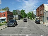
Mount Victory is a village in Hardin County
, Ohio
, United States
. The population was 600 at the 2000 census. It is home to a quaint downtown main street along busy State Route 31
between Marysville
and Kenton
, and to a volunteer fire department
.
According to the United States Census Bureau
, the village has a total area of 0.8 square miles (2.1 km²), all of it land.
of 2000, there were 600 people, 245 households, and 171 families residing in the village. The population density
was 791.3 people per square mile (304.8/km²). There were 263 housing units at an average density of 346.8 per square mile (133.6/km²). The racial makeup of the village was 98.83% White, 0.17% African American, and 1.00% from two or more races. Hispanic or Latino of any race were 0.83% of the population.
There were 245 households out of which 32.7% had children under the age of 18 living with them, 51.8% were married couples
living together, 12.2% had a female householder with no husband present, and 30.2% were non-families. 25.7% of all households were made up of individuals and 11.0% had someone living alone who was 65 years of age or older. The average household size was 2.45 and the average family size was 2.86.
In the village the population was spread out with 25.5% under the age of 18, 9.8% from 18 to 24, 28.8% from 25 to 44, 21.2% from 45 to 64, and 14.7% who were 65 years of age or older. The median age was 35 years. For every 100 females there were 92.9 males. For every 100 females age 18 and over, there were 93.5 males.
The median income for a household in the village was $40,694, and the median income for a family was $47,273. Males had a median income of $33,571 versus $22,344 for females. The per capita income
for the village was $17,745. About 3.8% of families and 6.9% of the population were below the poverty line, including 6.1% of those under age 18 and 10.8% of those age 65 or over.
Hardin County, Ohio
Hardin County is a county located in the state of Ohio, United States. As of the 2010 census, the population was 32,058. Its county seat is Kenton and is named for John Hardin, an officer in the American Revolution.-Geography:According to the U.S...
, Ohio
Ohio
Ohio is a Midwestern state in the United States. The 34th largest state by area in the U.S.,it is the 7th‑most populous with over 11.5 million residents, containing several major American cities and seven metropolitan areas with populations of 500,000 or more.The state's capital is Columbus...
, United States
United States
The United States of America is a federal constitutional republic comprising fifty states and a federal district...
. The population was 600 at the 2000 census. It is home to a quaint downtown main street along busy State Route 31
Ohio State Route 31
State Route 31 is an Ohio state highway that currently runs from Marysville to Kenton. Before 1938, however, it stretched far longer, from Pomeroy on the Ohio River to Findlay.-History:* 1924: Route 21 established from Pomeroy to Findlay....
between Marysville
Marysville, Ohio
Marysville is a city in and the county seat of Union County, Ohio, United States. The population was 15,942 at the 2000 census, and the Census Bureau estimated that it had risen to 17,621 by 2006.Marysville's longtime slogan is "Where the Grass is Greener"...
and Kenton
Kenton, Ohio
Kenton is a city in and the county seat of Hardin County, Ohio, United States, along the Scioto River. The population was 8,262 at the 2010 census. It is named for Kentucky/Ohio frontiersman, Simon Kenton...
, and to a volunteer fire department
Volunteer fire department
See also the Firefighter article and its respective sections regarding VFDs in other countries.A volunteer fire department is a fire department composed of volunteers who perform fire suppression and other related emergency services for a local jurisdiction.The first organized force of...
.
Geography
Mount Victory is located at 40°32′3"N 83°31′13"W (40.534164, -83.520156).According to the United States Census Bureau
United States Census Bureau
The United States Census Bureau is the government agency that is responsible for the United States Census. It also gathers other national demographic and economic data...
, the village has a total area of 0.8 square miles (2.1 km²), all of it land.
Demographics
As of the censusCensus
A census is the procedure of systematically acquiring and recording information about the members of a given population. It is a regularly occurring and official count of a particular population. The term is used mostly in connection with national population and housing censuses; other common...
of 2000, there were 600 people, 245 households, and 171 families residing in the village. The population density
Population density
Population density is a measurement of population per unit area or unit volume. It is frequently applied to living organisms, and particularly to humans...
was 791.3 people per square mile (304.8/km²). There were 263 housing units at an average density of 346.8 per square mile (133.6/km²). The racial makeup of the village was 98.83% White, 0.17% African American, and 1.00% from two or more races. Hispanic or Latino of any race were 0.83% of the population.
There were 245 households out of which 32.7% had children under the age of 18 living with them, 51.8% were married couples
Marriage
Marriage is a social union or legal contract between people that creates kinship. It is an institution in which interpersonal relationships, usually intimate and sexual, are acknowledged in a variety of ways, depending on the culture or subculture in which it is found...
living together, 12.2% had a female householder with no husband present, and 30.2% were non-families. 25.7% of all households were made up of individuals and 11.0% had someone living alone who was 65 years of age or older. The average household size was 2.45 and the average family size was 2.86.
In the village the population was spread out with 25.5% under the age of 18, 9.8% from 18 to 24, 28.8% from 25 to 44, 21.2% from 45 to 64, and 14.7% who were 65 years of age or older. The median age was 35 years. For every 100 females there were 92.9 males. For every 100 females age 18 and over, there were 93.5 males.
The median income for a household in the village was $40,694, and the median income for a family was $47,273. Males had a median income of $33,571 versus $22,344 for females. The per capita income
Per capita income
Per capita income or income per person is a measure of mean income within an economic aggregate, such as a country or city. It is calculated by taking a measure of all sources of income in the aggregate and dividing it by the total population...
for the village was $17,745. About 3.8% of families and 6.9% of the population were below the poverty line, including 6.1% of those under age 18 and 10.8% of those age 65 or over.