

Mount Stromlo
Encyclopedia
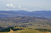
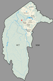
Canberra
Canberra is the capital city of Australia. With a population of over 345,000, it is Australia's largest inland city and the eighth-largest city overall. The city is located at the northern end of the Australian Capital Territory , south-west of Sydney, and north-east of Melbourne...
, Australia
Australia
Australia , officially the Commonwealth of Australia, is a country in the Southern Hemisphere comprising the mainland of the Australian continent, the island of Tasmania, and numerous smaller islands in the Indian and Pacific Oceans. It is the world's sixth-largest country by total area...
, near the district of Weston Creek
Weston Creek
Weston Creek is a residential district of Canberra, Australian Capital Territory, Australia, situated to the west of the Woden Valley district and approximately 13 km southwest of the Canberra city centre...
. Its peak is at approximately 770m AHD
Australian Height Datum
The Australian Height Datum is a geodetic datum for altitude measurement in Australia. According to Geoscience Australia, "In 1971 the mean sea level for 1966-1968 was assigned the value of zero on the Australian Height Datum at thirty tide gauges around the coast of the Australian continent...
.
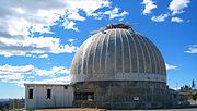
It is most notable as the location of the Mount Stromlo Observatory
Mount Stromlo Observatory
Mount Stromlo Observatory located just outside of Canberra, Australia, is part of the Research School of Astronomy and Astrophysics at the Australian National University .-History:...
(run by the Australian National University
Australian National University
The Australian National University is a teaching and research university located in the Australian capital, Canberra.As of 2009, the ANU employs 3,945 administrative staff who teach approximately 10,000 undergraduates, and 7,500 postgraduate students...
) and Canberra's primary water supply treatment plant, supplied by the Cotter River
Cotter River
The Cotter River is a fresh water river in the Australian Capital Territory. It is a tributary of the Murrumbidgee River and part of Murray-Darling Basin. The Cotter River is one of two rivers—the Queanbeyan River is the other—that meet the water supply needs of the Canberra and...
catchment area.
The name is derived from Mount Strom, the earlier official name.
History
The first telescope installed at Mount Stromlo was the Oddie telescope which was installed on 8 September 1911. The building housing this telescope was the first construction funded by the Commonwealth in Canberra.In January 1913 the first telephone was connected to the Queanbeyan telephone exchange.
Mount Stromlo was devastated by the Canberra bushfires of 2003. The fire, fueled by the pine plantation that covered the mountain, destroyed or badly damaged much of the observatory and water treatment plant.
Road access is via the Cotter Road on the south side, and Uriarra Road on the east and north. The summit is reached by a road joining Cotter road just outside Duffy.
Mountain biking
Mount Stromlo is home to one of the finest and most well equipped mountain biking facilities in Australia. Prior to the devastating 2003 fires Mount Stromlo hosted some of the best and oldest mountain bike trails in Australia. In May 2006 extensive remedial work and trail reconstruction was commenced by World Trail, led by Glenn Jacobs, in partnership with Canberra Off-Road Cyclists mountain bike club and the ACT Government. Stromlo Forest Park now includes more than 35 km of cross country single trail, a Four-CrossFour-cross
Four-cross , also called Mountain-cross, not to be confused with Fourcross, is a relatively new style of mountain bike racing where four bikers race downhill on a prepared, BMX like, track, simply trying to get down first. These bikes are generally either full suspension with 3 to 4 inches of...
course , several observed trials areas and a downhill track.
Mount Stromlo was selected to host the 2009 UCI Mountain Bike & Trials World Championships. The Championships were staged from September 1 to 6, 2009 and attracted more than 30,000 visitors from up to 40 countries. The event involved more than 750 of the world's top riders who competed in the four mountain bike disciplines of Cross Country, Downhill, Four Cross and Observed Trials.
In addition to the mountain biking facilities Mount Stromlo also boasts an event pavilion with office space and change rooms, a kids play area, BBQ's, a road cycling criterium circuit, a groomed grass cross country running track and equestrian trails.
Geology
The rock on Mount Stromlo consists of ignimbriteIgnimbrite
An ignimbrite is the deposit of a pyroclastic density current, or pyroclastic flow, a hot suspension of particles and gases that flows rapidly from a volcano, driven by a greater density than the surrounding atmosphere....
from the Laidlaw Volcanics. This erupted in the upper Silurian
Silurian
The Silurian is a geologic period and system that extends from the end of the Ordovician Period, about 443.7 ± 1.5 Mya , to the beginning of the Devonian Period, about 416.0 ± 2.8 Mya . As with other geologic periods, the rock beds that define the period's start and end are well identified, but the...
period over the top of the Deakin Volcanics rhyodacite
Rhyodacite
Rhyodacite is an extrusive volcanic rock intermediate in composition between dacite and rhyolite. It is the extrusive equivalent of granodiorite. Phenocrysts of sodium rich plagioclase, sanidine, quartz, and biotite or hornblende are typically set in an aphanitic to glassy light to intermediate...
which is visible on the surface on the lower slopes in the east and southeast sides. The northern lower slopes are covered with a calcareous shale
Shale
Shale is a fine-grained, clastic sedimentary rock composed of mud that is a mix of flakes of clay minerals and tiny fragments of other minerals, especially quartz and calcite. The ratio of clay to other minerals is variable. Shale is characterized by breaks along thin laminae or parallel layering...
which is included in the Laidlaw Volcanics as it was deposited at the same time. This is cut off on the northwest side by the Winslade Fault, which heads north east to Cook and Kaleen. A spur fault heads off east from the Winslade Fault to under the Scrivener Dam. On the other side (north west and north) of these faults are middle Silurian period rhyodacite volcanic deposits from the Walker Volcanics. The northern side was uplifted compared with the southern side.
Landform
Stoney Creek and its tributaries drain the north side of the mountain, The east side drains into the Molonglo River. The south side supplies Blugar creek that runs into the Murrumbidgee River.The top of the mountain where the telescopes are located is elongated in a north-south direction with a spur running to the southwest where the water treatment plant is situated.