
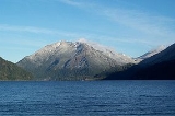
Mount Storm King
Encyclopedia
Mount Storm King is located within the Olympic National Park
about 20 miles west of Port Angeles
, Washington. The mountain is located on the south side of Lake Crescent
near Barnes Point
, and has an elevation of 4537 feet (1,382.9 m).
The trail to the summit starts near the Storm King Ranger Station
, and initially follows the trail to Marymere Falls
but branches to the north after a short distance. The first 1.9 miles (3.1 km) miles is on maintained trail but the rest of the climb involves scrambling
on loose rock with some exposure.
Olympic National Park
Olympic National Park is located in the U.S. state of Washington, in the Olympic Peninsula. The park can be divided into four basic regions: the Pacific coastline, alpine areas, the west side temperate rainforest and the forests of the drier east side. U.S...
about 20 miles west of Port Angeles
Port Angeles, Washington
Port Angeles is a city in and the county seat of Clallam County, Washington, United States. The population was 19,038 at the 2010 census. The area's harbor was dubbed Puerto de Nuestra Señora de los Ángeles by Spanish explorer Francisco de Eliza in 1791, but by the mid-19th century the name had...
, Washington. The mountain is located on the south side of Lake Crescent
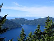
Lake Crescent
Lake Crescent is a deep lake located entirely within Olympic National Park in Clallam County, Washington, United States, approximately west of Port Angeles, Washington on U.S. Route 101 and nearby to the small community of Piedmont...
near Barnes Point
Barnes Point
Barnes Point is an ancient landslide delta that juts out into Lake Crescent in Clallam County, Washington. As one of the few areas of relatively flat ground near Lake Crescent, it hosts Lake Crescent Lodge, the Storm King Ranger Station of Olympic National Park, as well as several private homes. It...
, and has an elevation of 4537 feet (1,382.9 m).
The trail to the summit starts near the Storm King Ranger Station
Storm King Ranger Station
The Storm King Ranger Station is located on Barnes Point on Lake Crescent off of U.S. Route 101 in Washington about 15 miles west of Port Angeles, Washington. The ranger station is part of the Olympic National Park. The station was added to the National Register of Historic Places on July 13, 2007...
, and initially follows the trail to Marymere Falls
Marymere Falls
Marymere Falls is located in Olympic National Park near Lake Crescent in Washington, United States. The falls are accessed by a one-mile trail. Falls creek descends from Aurora Ridge and tumbles over Marymere Falls and then flows into Barnes Creek. It has a height of 90 feet. The falls is one of...
but branches to the north after a short distance. The first 1.9 miles (3.1 km) miles is on maintained trail but the rest of the climb involves scrambling
Scrambling
Scrambling is a method of ascending rocky faces and ridges. It is an ambiguous term that lies somewhere between hillwalking and rock climbing. It is often distinguished from hillwalking by defining a scramble as a route where hands must be used in the ascent...
on loose rock with some exposure.