
Mount Pinos
Encyclopedia
Mount Pinos is a mountain located in the Los Padres National Forest
on the boundary between Ventura
and Kern
counties in California
. The summit is the highest point in Ventura County.
and Frazier Park are about 10 miles (16.1 km) to the east.
The view from the summit on a clear day encompasses the southern Central Valley
, the southernmost Sierra Nevada, much of northern Ventura county, much of the Santa Barbara County mountains, the Caliente Range
and the Carrizo Plain
. The trace of the San Andreas Fault
, clearly visible to the northwest, cuts between Mount Pinos and the mountains immediately to the north. The trace extends all the way to Soda Lake in the Carrizo Plain along the Elkhorn Scarp. The lights of Bakersfield and surrounding towns are visible on a clear evening to the north and northeast.
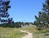
The summit of the mountain itself is relatively flat and open with several subsidiary summits. Open stands of conifers separated by brushy areas predominate.
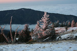
. Most of the precipitation falls as winter snow. The area experiences several feet (1 to 2 metres) of snow each year with snowfields lasting till early June on the north facing slopes. In heavy snowfall years snowfields can last till late July or later. Temperatures fall to near freezing most days in the coldest months while lows drop into the teens.
Summer months are mild with high temperatures between 70 °F (21.1 °C) and 80 °F (26.7 °C). The mountain experiences occasional thunderstorms with some delivering intense, localized downpours.
, was considered by the Chumash people to be the center of the world or Liyikshup. The point where everything is in balance. The summit is the highest in the area and near the center of the traditional lands of the Chumash.
and ends at Mount Abel (Cerro Noroeste)
. Almost all of this 6 miles (9.7 km) trail is above 8000 feet (2,438.4 m).
 Consistent snow conditions on Mount Pinos allows for many types of winter recreation. This includes cross country and telemark skiing
, snowboarding, sledding, and snow camping. The network of ski trails and backcountry telemark and snowboarding bowls on Mount Pinos are documented on several locally-produced maps. The ski trails are part of a dispersed recreation area administered in partnership by the United States Forest Service, Los Padres National Forest, local Frazier Park-area businesses and the Mount Pinos Nordic Ski Patrol. The patrol
operates the Nordic Base facility located at the top of Mount Pinos Road and adjacent to the Chula Vista parking lot.
From the Chula Vista parking lot a trail network spreads both uphill towards Condor Point and downhill reaching as far as McGill Campground. Skiing and boarding are also available in backcountry bowls on the north face of the peak and ridges that drop all the way down the mountain to about the 6000 feet (1,828.8 m) level. Popular destinations include Condor Point, 1st and 2nd Meadows, and Inspiration Point. The Overlook trail accesses the North Ridge area which hosted an alpine ski area during the 1960s. The area lifts were rope tows situated on the three fingers of the drainage just north of Overlook trail.
More ambitious back country skiing can include trips to nearby Sheep Camp on Sawmill Mountain, Mount Abel (Cerro Noroeste) and if snow conditions allow a descent all the way to Pine Mountain Club.
During and immediately after heavy snow storms it may not be possible to drive to the top of Mount Pinos Road due to the lack of snow plow availability. In such cases it is common for the Kern County Roads Department to close a snow gate lower on the mountain. It is still possible to ski from the snow gate and enjoy the lower slopes of Mount Pinos. Snow at lower elevations also facilitates cross country skiing to Iris Point which provides great views of Lockwood Valley.
It is important to note that some of these trails depend on sufficient snowpack. The trails are not declared hiking trails in the summer and consequently a separate hiking map is available from the Forest Service.
Other nearby recreational opportunities include astronomy, fishing, off-roading, horseback riding and bouldering.
Mount Pinos is often referred to by Adam Carolla
on his radio show and podcasts.
The usual viewing area is not the summit of the mountain, but the large tree-surrounded parking area about two miles east of the peak.
Los Padres National Forest
Los Padres National Forest is a forest located in southern and central California, which includes most of the mountainous land along the California coast from Ventura to Monterey, extending inland...
on the boundary between Ventura
Ventura County, California
Ventura County is a county in the southern part of the U.S. state of California. It is located on California's Pacific coast. It is often referred to as the Gold Coast, and has a reputation of being one of the safest populated places and one of the most affluent places in the country...
and Kern
Kern County, California
Spreading across the southern end of the California Central Valley, Kern County is the fifth-largest county by population in California. Its economy is heavily linked to agriculture and to petroleum extraction, and there is a strong aviation and space presence. Politically, it has generally...
counties in California
California
California is a state located on the West Coast of the United States. It is by far the most populous U.S. state, and the third-largest by land area...
. The summit is the highest point in Ventura County.
Geography
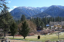
The small community of Pine Mountain Club lies due north of Mount Pinos. Lake of the WoodsLake of the Woods, California
Lake of the Woods is an unincorporated area and census-designated place in Kern County, California. The population was 917 at the 2010 census, up from 833 at the 2000 census. The community is contained in Cuddy Canyon along the Ventura and Kern County line inside the Los Padres National Forest. It...
and Frazier Park are about 10 miles (16.1 km) to the east.
The view from the summit on a clear day encompasses the southern Central Valley
California Central Valley
California's Central Valley is a large, flat valley that dominates the central portion of California. It is home to California's most productive agricultural efforts. The valley stretches approximately from northwest to southeast inland and parallel to the Pacific Ocean coast. Its northern half is...
, the southernmost Sierra Nevada, much of northern Ventura county, much of the Santa Barbara County mountains, the Caliente Range
Caliente Range
The Caliente Range is a west-east trending zone of uplift mountains in the Pacific Coast Ranges, in central California. They are home to 5106 foot Caliente Mountain, the highest peak in San Luis Obispo County, California.-Geologic setting:...
and the Carrizo Plain
Carrizo Plain
The Carrizo Plain is a large enclosed plain, approximately 50 miles long and up to 15 miles across, in southeastern San Luis Obispo County, California, about 100 miles northwest of Los Angeles, California...
. The trace of the San Andreas Fault
San Andreas Fault
The San Andreas Fault is a continental strike-slip fault that runs a length of roughly through California in the United States. The fault's motion is right-lateral strike-slip...
, clearly visible to the northwest, cuts between Mount Pinos and the mountains immediately to the north. The trace extends all the way to Soda Lake in the Carrizo Plain along the Elkhorn Scarp. The lights of Bakersfield and surrounding towns are visible on a clear evening to the north and northeast.
The summit of the mountain itself is relatively flat and open with several subsidiary summits. Open stands of conifers separated by brushy areas predominate.
Climate
The summit plateau experiences harsh winters in comparison to most of Southern CaliforniaSouthern California
Southern California is a megaregion, or megapolitan area, in the southern area of the U.S. state of California. Large urban areas include Greater Los Angeles and Greater San Diego. The urban area stretches along the coast from Ventura through the Southland and Inland Empire to San Diego...
. Most of the precipitation falls as winter snow. The area experiences several feet (1 to 2 metres) of snow each year with snowfields lasting till early June on the north facing slopes. In heavy snowfall years snowfields can last till late July or later. Temperatures fall to near freezing most days in the coldest months while lows drop into the teens.
Summer months are mild with high temperatures between 70 °F (21.1 °C) and 80 °F (26.7 °C). The mountain experiences occasional thunderstorms with some delivering intense, localized downpours.
Wildlife
Mount Pinos is considered by ecologists to be home to one of the most significant populations of birds of prey in California. In the area live five owl species, northern goshawks, as well as California Condors.Significance to Chumash people
Mount Pinos, or Iwihinmu in the Chumashan languageChumashan languages
Chumashan is a family of languages that were spoken on the southern California coast by Native American Chumash people.From the Coastal plains and valleys of San Luis Obispo to Malibu), neighboring inland and Transverse Ranges valleys and canyons east to bordering the San Joaquin Valley; and on...
, was considered by the Chumash people to be the center of the world or Liyikshup. The point where everything is in balance. The summit is the highest in the area and near the center of the traditional lands of the Chumash.
Hiking
The summit of Pinos can be reached by a 2 miles (3.2 km) hike along a dirt road from a parking area at the end of Los Padres National Forest Road S349S. The trail continues to the west entering the Chumash WildernessChumash Wilderness
The Chumash Wilderness is a wilderness area in the mountains of northern Ventura County and southwestern Kern County in California, USA. It is completely within the Los Padres National Forest, and includes most of the highest terrain in Ventura County...
and ends at Mount Abel (Cerro Noroeste)
Cerro Noroeste
Cerro Noroeste is a mountain located in Southern California's Kern County, a mile north of the Ventura County border. It is located a few miles southwest of the community of Pine Mountain Club, at an elevation of 8,280+ feet . The mountain is located in the Los Padres National Forest...
. Almost all of this 6 miles (9.7 km) trail is above 8000 feet (2,438.4 m).
Snow Sports
Telemark skiing
Telemark skiing is a form of skiing using the Telemark turn. Unlike alpine skiing equipment, the skis used for telemarking either have a binding that only connects the boot to the ski at the toes, just as in cross-country skiing, or may be released to only connect there.Telemark turns are led with...
, snowboarding, sledding, and snow camping. The network of ski trails and backcountry telemark and snowboarding bowls on Mount Pinos are documented on several locally-produced maps. The ski trails are part of a dispersed recreation area administered in partnership by the United States Forest Service, Los Padres National Forest, local Frazier Park-area businesses and the Mount Pinos Nordic Ski Patrol. The patrol
operates the Nordic Base facility located at the top of Mount Pinos Road and adjacent to the Chula Vista parking lot.
From the Chula Vista parking lot a trail network spreads both uphill towards Condor Point and downhill reaching as far as McGill Campground. Skiing and boarding are also available in backcountry bowls on the north face of the peak and ridges that drop all the way down the mountain to about the 6000 feet (1,828.8 m) level. Popular destinations include Condor Point, 1st and 2nd Meadows, and Inspiration Point. The Overlook trail accesses the North Ridge area which hosted an alpine ski area during the 1960s. The area lifts were rope tows situated on the three fingers of the drainage just north of Overlook trail.
More ambitious back country skiing can include trips to nearby Sheep Camp on Sawmill Mountain, Mount Abel (Cerro Noroeste) and if snow conditions allow a descent all the way to Pine Mountain Club.
During and immediately after heavy snow storms it may not be possible to drive to the top of Mount Pinos Road due to the lack of snow plow availability. In such cases it is common for the Kern County Roads Department to close a snow gate lower on the mountain. It is still possible to ski from the snow gate and enjoy the lower slopes of Mount Pinos. Snow at lower elevations also facilitates cross country skiing to Iris Point which provides great views of Lockwood Valley.
It is important to note that some of these trails depend on sufficient snowpack. The trails are not declared hiking trails in the summer and consequently a separate hiking map is available from the Forest Service.
Other nearby recreational opportunities include astronomy, fishing, off-roading, horseback riding and bouldering.
Mount Pinos is often referred to by Adam Carolla
Adam Carolla
Adam Carolla is an American radio personality, television host, comedian, and actor. He currently hosts The Adam Carolla Show, a talk show distributed as a podcast on the ACE Broadcasting Network...
on his radio show and podcasts.
Astronomy
Mount Pinos is considered to be one of the best viewing sites in Southern California due to its relatively low light pollution, dry air and frequently clear skies and is one of the favorite gathering places for amateur astronomers in the region,The usual viewing area is not the summit of the mountain, but the large tree-surrounded parking area about two miles east of the peak.
See also
- List of highest points in California by county
- Mountain peaks of CaliforniaMountain peaks of CaliforniaThis article comprises three sortable tables of major mountain peaks of the U.S. State of California.Topographic elevation is the vertical distance above the reference geoid, a precise mathematical model of the Earth's sea level as an equipotential gravitational surface...