

Mount Erie (Washington)
Encyclopedia
Anacortes, Washington
Anacortes is a city in Skagit County, Washington, United States. The name "Anacortes" is a consolidation of the name Anna Curtis, who was the wife of early Fidalgo Island settler Amos Bowman. Anacortes' population was 15,778 at the time of the 2010 census...
and is located in the south of the Anacortes Community Forest Lands
Anacortes Community Forest Lands
Anacortes Community Forest Lands consists of mostly forested lands surrounding and adjoining Little Cranberry, Heart, and Whistle Lakes on Fidalgo Island, west and south of Anacortes, Washington. Its highest point is Mount Erie, the highest point on the island at . Sugarloaf, 1,044 feet and 0.6...
.
Mount Erie was named in 1841 by the Wilkes Expedition for the Battle of Lake Erie
Battle of Lake Erie
The Battle of Lake Erie, sometimes called the Battle of Put-in-Bay, was fought on 10 September 1813, in Lake Erie off the coast of Ohio during the War of 1812. Nine vessels of the United States Navy defeated and captured six vessels of Great Britain's Royal Navy...
.
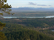
The mountain itself was first explored in the 1960s by local climbers, including Dallas Kloke. The mountain is known for its climbing as well as the view from the summit. Mount Erie is a city park operated by the City of Anacortes
Anacortes, Washington
Anacortes is a city in Skagit County, Washington, United States. The name "Anacortes" is a consolidation of the name Anna Curtis, who was the wife of early Fidalgo Island settler Amos Bowman. Anacortes' population was 15,778 at the time of the 2010 census...
and the summit is accessible via a single-lane, paved road from the base. At 1,273 feet (388 meters) tall, Mount Erie is the highest point on Fidalgo Island
Fidalgo Island
Fidalgo Island is an island in Skagit County, Washington, located about north of Seattle. To the east, it is separated from the mainland by the Swinomish Channel, and from Whidbey Island to the south by Deception Pass...
.
The mountain is composed mostly of feldspar
Feldspar
Feldspars are a group of rock-forming tectosilicate minerals which make up as much as 60% of the Earth's crust....
and hornblende
Hornblende
Hornblende is a complex inosilicate series of minerals .It is not a recognized mineral in its own right, but the name is used as a general or field term, to refer to a dark amphibole....
rich diorite
Diorite
Diorite is a grey to dark grey intermediate intrusive igneous rock composed principally of plagioclase feldspar , biotite, hornblende, and/or pyroxene. It may contain small amounts of quartz, microcline and olivine. Zircon, apatite, sphene, magnetite, ilmenite and sulfides occur as accessory...
.
Geology
Located near the Fidalgo Complex in the San Juan Islands of Washington Mt. Erie has a unique and somewhat puzzling composition. Mt. Erie is thought to have been formed during the Jurassic period (155-170 Ma.) by invasive volcanic flows creating batholithic masses of diorite, which also helped to create the island arcs associated with the San Juan Islands. By the end of the late Jurassic period the area experienced uplift and erosion and was subjected to intense folding and faulting. At this point most of the deposited Paleozoic and Mesozoic sediments had been eroded away exposing the plutons of diorite, which is the primary igneous rock found on Mt Erie.The diorite pluton, at some point, experienced intrusion by gabbro dikes associated with the formation of oceanic seafloor. Indicating that the area may have experienced periods of submersion, as the Juan de Fuca plate subducted underneath the North American plate accreted the area. This whole process of constant uplift and erosion followed by accretion is thought to have created the unique ophialites associated with the San Juan Islands and primarily the Fidalgo Complex located near the mountain.
During the Quaternary Period the area experienced many glacial periods and retreats and such evidence for the glacial erosion of Mt. Erie itself can be observed at the summit of the mountain as large striations in the diorite and gabbro. These periods of glacial erosion were separated by warming trends and continue to present day.