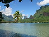
Home      Discussion      Topics      Dictionary      Almanac
Signup       Login
Moorea

Moorea

Overview
Moʻorea is a high island
High island
In geology , a high island is an island of volcanic origin. The term can be used to distinguish such islands from low islands, whose origin is due to sedimentation or uplifting of coral reefs.-Definition and origin:...

 in French Polynesia
French Polynesia
French Polynesia is an overseas country of the French Republic . It is made up of several groups of Polynesian islands, the most famous island being Tahiti in the Society Islands group, which is also the most populous island and the seat of the capital of the territory...

, part of the Society Islands
Society Islands
The Society Islands are a group of islands in the South Pacific Ocean. They are politically part of French Polynesia. The archipelago is generally believed to have been named by Captain James Cook in honor of the Royal Society, the sponsor of the first British scientific survey of the islands;...

, 17 km (roughly 9 mi) northwest of Tahiti
Tahiti
Tahiti is the largest island in the Windward group of French Polynesia, located in the archipelago of the Society Islands in the southern Pacific Ocean. It is the economic, cultural and political centre of French Polynesia. The island was formed from volcanic activity and is high and mountainous...

. Its position is 17°32′S 149°50′W. Moʻorea means "yellow lizard" in Tahitian
Tahitian language
Tahitian is an indigenous language spoken mainly in the Society Islands in French Polynesia. It is an Eastern Polynesian language closely related to the other indigenous languages spoken in French Polynesia: Marquesan, Tuamotuan, Mangarevan, and Austral Islands languages...

. An older name for the island is 'ʻAimeho, sometimes spelled 'Aimeo or 'ʻEimeo (among other spellings misunderstood by early visitors with no knowledge of the language). Early Western colonists and voyagers also referred to Moʻorea as York Island.
Discussion
Ask a question about 'Moorea'
Start a new discussion about 'Moorea'
Answer questions from other users
Full Discussion Forum
 
Unanswered Questions
Encyclopedia
Moʻorea is a high island
High island
In geology , a high island is an island of volcanic origin. The term can be used to distinguish such islands from low islands, whose origin is due to sedimentation or uplifting of coral reefs.-Definition and origin:...

 in French Polynesia
French Polynesia
French Polynesia is an overseas country of the French Republic . It is made up of several groups of Polynesian islands, the most famous island being Tahiti in the Society Islands group, which is also the most populous island and the seat of the capital of the territory...

, part of the Society Islands
Society Islands
The Society Islands are a group of islands in the South Pacific Ocean. They are politically part of French Polynesia. The archipelago is generally believed to have been named by Captain James Cook in honor of the Royal Society, the sponsor of the first British scientific survey of the islands;...

, 17 km (roughly 9 mi) northwest of Tahiti
Tahiti
Tahiti is the largest island in the Windward group of French Polynesia, located in the archipelago of the Society Islands in the southern Pacific Ocean. It is the economic, cultural and political centre of French Polynesia. The island was formed from volcanic activity and is high and mountainous...

. Its position is 17°32′S 149°50′W. Moʻorea means "yellow lizard" in Tahitian
Tahitian language
Tahitian is an indigenous language spoken mainly in the Society Islands in French Polynesia. It is an Eastern Polynesian language closely related to the other indigenous languages spoken in French Polynesia: Marquesan, Tuamotuan, Mangarevan, and Austral Islands languages...

. An older name for the island is 'ʻAimeho, sometimes spelled 'Aimeo or 'ʻEimeo (among other spellings misunderstood by early visitors with no knowledge of the language). Early Western colonists and voyagers also referred to Moʻorea as York Island.

Transportation


Several ferries go to the Vai'are wharf in Mo'orea daily from Papeetē
Papeete
-Sights:* Interactive Google map of Papeete, to discover the 30 major tourist attractions in Papeete downtown.*The waterfront esplanade*Bougainville Park -Sights:* Interactive Google map of Papeete, to discover the 30 major tourist attractions in Papeete downtown.*The waterfront...

, the Tahitian capital. The Vai'are wharf is in the Vai'are bay. There are 3 ferries. One of them is the 'Aremiti 5. The largest one is the 'Aremiti Ferry and the other one is the Moorea ferry. The ferries have to pass through Mo'orea's coral pass, then toward Papeetē across the ocean and into the Tahiti Lagoon. The Vai'are bay is in the east part of Mo'orea. Mo'orea's Temaʻe Airport (MOZ) has connections to the international airport in Papeetē and onward to other Society Islands such as Pora Pora. If the islanders want to make an international flight, they would take Air Tahiti to get to the Fa'a'a International Airport on Tahiti
Tahiti
Tahiti is the largest island in the Windward group of French Polynesia, located in the archipelago of the Society Islands in the southern Pacific Ocean. It is the economic, cultural and political centre of French Polynesia. The island was formed from volcanic activity and is high and mountainous...

. The Mo'orea airport is located north of the Vai'are bay. There is one road that goes around the island. Along the road are kilometer markers from 1 to 35. The first one is near the airport. The 35th one is in Ha'apiti. There are also white signs that tell the driver which commune they entered. Other signs have the communes name with a red slash through it, meaning that the driver is leaving the commune.

Geography


Mo'orea is about 10 miles in width from the west to the east. There are two small, nearly symmetrical bays on the north shore. The one to the west is called 'Ōpūnohu Bay
Opunohu Bay
Opunohu Bay is a bay on the island of Moorea, Tahiti. It is a narrow, straight, 3-km long bay with a water depth of about 80 metres at the mouth. Offshore winds along the axis of the bay generates an outflow at the surface and an inflow below 20 metres depth...

 which isn't very populated but many travelers have come into the bay. The main surrounding communes of the bay are Piha'ena in the east and Papeto'ai to the west. The one to the east is Cook's Bay, also called Pao Pao Bay since the largest commune of Mo'orea is at the bottom of the bay. The other communes are Piha'ena to the west and busy Maharepa to the east. The highest point is Mount Tohi'e'a
Mount Tohivea
Mount Tohivea is a volcanic peak at 3,960 feet that is the highest point on the island of Moorea in French Polynesia. On its slopes are many streams and fertile soils. There are Hiking Trails along along the summit close to the Belvedere point were people can view the 2 Bays, Mont Routui, and the...

, near the center of Mo'orea. It dominates the vista from the two bays and can be seen from Tahiti
Tahiti
Tahiti is the largest island in the Windward group of French Polynesia, located in the archipelago of the Society Islands in the southern Pacific Ocean. It is the economic, cultural and political centre of French Polynesia. The island was formed from volcanic activity and is high and mountainous...

. There are also hiking trails in the mountains. The Vai'are Bay is another small inlet, smaller than the two main bays, on the east shore. This bay has been settled a lot and has a lot of business. The main village is located just south of the bay.

Politics


The island is administratively part of the commune (municipality) of Moʻorea-Maiʻao
Moorea-Maiao
Moorea-Maiao is a commune of French Polynesia, an overseas territory of France in the Pacific Ocean. The commune is in the administrative subdivision of the Windward Islands....

, itself in the administrative subdivision of the Windward Islands
Windward Islands (Society Islands)
The Windward Islands are the eastern group of the Society Islands in French Polynesia, an overseas collectivity of France in the southern Pacific Ocean.-Geography:...

. The main village is ʻĀfareaitu. The largest village is Pao Pao at the bottom of Cook's bay. The 2nd largest is Maharepa.

Tourism


Because of its stunning scenery and accessibility to Papeetē, Moʻorea is visited by many western tourists who travel to French Polynesia. Especially popular as a honeymoon
Honeymoon
-History:One early reference to a honeymoon is in Deuteronomy 24:5 “When a man is newly wed, he need not go out on a military expedition, nor shall any public duty be imposed on him...

 destination, Moʻorea can often be seen in advertisements in American wedding magazines.
Authur Frommer declared in Frommer's
Frommer's
Frommer's is a travel guidebook series and one of the bestselling travel guides in America. The series began in 1957 with the publication of Arthur Frommer's book, Europe on $5 a Day. Frommer's has expanded to include over 350 guidebooks across 14 series, as well as other media including the award...

 travel guide that he considered it the most beautiful island in the world.

Physical description


From above, the shape of the island vaguely resembles a heart, with its two nearly symmetrical bays opening to the north side of the island: Cook's (or Paopao) Bay and ʻŌpūnohu Bay
Opunohu Bay
Opunohu Bay is a bay on the island of Moorea, Tahiti. It is a narrow, straight, 3-km long bay with a water depth of about 80 metres at the mouth. Offshore winds along the axis of the bay generates an outflow at the surface and an inflow below 20 metres depth...

. The island was formed as a volcano 1.5 to 2.5 million years ago, the result of a geologic hotspot
Hotspot (geology)
The places known as hotspots or hot spots in geology are volcanic regions thought to be fed by underlying mantle that is anomalously hot compared with the mantle elsewhere. They may be on, near to, or far from tectonic plate boundaries. There are two hypotheses to explain them...

 in the mantle under the oceanic plate that formed the whole of the Society Archipelago. It is theorized that the current bays were formerly river basins that filled during the Holocene
Holocene
The Holocene is a geological epoch which began at the end of the Pleistocene and continues to the present. The Holocene is part of the Quaternary period. Its name comes from the Greek words and , meaning "entirely recent"...

 searise.

History


Like many of the other islands, Mo'orea was first settled by Polynesian from the islands west of Mo'orea. They arrived on canoes coming down from South Asia looking for islands to settle. They arrived to Mo'orea 1000 years ago. There are some ancient landmarks like Marae. Marae are anciant stone rocks that are shaped like pyramids. On the rocks are carvings that tell when sacrifices sometimes took place. The oldest marae is the 'Āfareaitu Marae located in the island's main village. It was made by the early Polynesians in the year 900. People can easily visit the 'Āfareaitu Marae. The first settlers who were Europeans arrived during the 18th century. The first European to arrive on the island were Englishman Samuel Wallis
Samuel Wallis
Samuel Wallis was a Cornish navigator who circumnavigated the world.Wallis was born near Camelford, Cornwall. In 1766 he was given the command of HMS Dolphin to circumnavigate the world, accompanied by the Swallow under the command of Philip Carteret...

 and James Cook
James Cook
Captain James Cook, FRS, RN was a British explorer, navigator and cartographer who ultimately rose to the rank of captain in the Royal Navy...

. Captain James Cook first settled on Tahiti
Tahiti
Tahiti is the largest island in the Windward group of French Polynesia, located in the archipelago of the Society Islands in the southern Pacific Ocean. It is the economic, cultural and political centre of French Polynesia. The island was formed from volcanic activity and is high and mountainous...

 and then he took his ship with Samuel Wallis and then he went onward to Mo'orea. Then the bay that he first settled in was Cook's bay which was later named after him.

Then was the French Tahitian War. The French won because they had guns and the Tahitians had only had knives and picks. Most of the Tahitians that fought were from Papeto'ai. Then Mo'orea was considered to be part of French Polynesia. Charles Darwin
Charles Darwin
Charles Robert Darwin FRS was an English naturalist. He established that all species of life have descended over time from common ancestry, and proposed the scientific theory that this branching pattern of evolution resulted from a process that he called natural selection.He published his theory...

 was inspired for his theory regarding the formation of coral atolls when looking down upon Moʻorea standing on a peak on Tahiti. He described it as a "picture in a frame", referring to the barrier reef
Barrier reef
Barrier reef may refer to:*a kind of coral reef*the Great Barrier Reef in Australia*the Mesoamerican Barrier Reef System*the Belize Barrier Reef*the New Caledonia Barrier Reef*Barrier Reef , an Australian television series...

 encircling the island. Don the Beachcomber
Don the Beachcomber
Donn Beach , born Ernest Raymond Beaumont Gantt, is the founding father of tiki restaurants, bars and nightclubs. The many so-called "Polynesian" restaurants and pubs that enjoyed great popularity are directly descended from what he created...

 lived here for some time until his houseboat
Houseboat
A houseboat is a boat that has been designed or modified to be used primarily as a human dwelling. Some houseboats are not motorized, because they are usually moored, kept stationary at a fixed point and often tethered to land to provide utilities...

 was destroyed by tropical cyclone
Tropical cyclone
A tropical cyclone is a storm system characterized by a large low-pressure center and numerous thunderstorms that produce strong winds and heavy rain. Tropical cyclones strengthen when water evaporated from the ocean is released as the saturated air rises, resulting in condensation of water vapor...

s.In the early 1900s, people started to make fire from leaves they didn't need so they could cook their food.
The island was among those visited by the United States Exploring Expedition
United States Exploring Expedition
The United States Exploring Expedition was an exploring and surveying expedition of the Pacific Ocean and surrounding lands conducted by the United States from 1838 to 1842. The original appointed commanding officer was Commodore Thomas ap Catesby Jones. The voyage was authorized by Congress in...

 on its tour of the South Pacific in 1839. Then transportation began Mo'orea. They built the main road and the Vai'are wharf. It took the Polynesians about 4 years to construct the 3 ferries that go daily from Mo'orea to Tahiti. Each of the ferries has different speeds. Then on October 7, 1967,the construction workers have finished building the Mo'orea Airport and the airport opened the next month. A group on Moʻorea island has succeeded in attracting about 100 people to attend a meeting of a purported new republic, called Hau Pakumotu in 2010. To this day, Mo'orea is visited a lot.

Research facilities


The University of California, Berkeley
University of California, Berkeley
The University of California, Berkeley , is a teaching and research university established in 1868 and located in Berkeley, California, USA...

 maintains the Richard B. Gump South Pacific Research Station on the west coast of Cook's Bay. The Gump station is also home to the Moʻorea Coral Reef Long Term Ecological Research Site (MCR LTER). The project, funded by the US National Science Foundation (NSF), is a partnership between the University of California Santa Barbara and California State University, Northridge that includes additional researchers from UC Davis, UC Santa Cruz, UC San Diego and the University of Hawaiʻi. The Moʻorea Coral Reef LTER is part of the National Science Foundation's Long Term Ecological Research (LTER) Network. The LTER Program was established by the NSF in 1980 to support research on long-term ecological phenomena. The Mo'orea Coral Reef LTER became the 26th site in the LTER network in September 2004.
The French EPHE (École pratique des hautes études) and now the CNRS (National Centre for Scientific Research) maintain a research station at the end of ʻŌpūnohu Bay since about 1970. This Centre de Recherches Insulaires et Observatoire de l'Environnement (Centre for island research and environment observatory) or CRIOBE is a research site for several international projects, including the monitoring of coral reefs throughout French Polynesia as well as the monitoring of the fish population on the Tīahurā transect of Moʻorea's reef for over 30 years.

See also

  • List of volcanoes in French Polynesia
  • Society Islands
    Society Islands
    The Society Islands are a group of islands in the South Pacific Ocean. They are politically part of French Polynesia. The archipelago is generally believed to have been named by Captain James Cook in honor of the Royal Society, the sponsor of the first British scientific survey of the islands;...

  • Windward Islands (Society Islands)
    Windward Islands (Society Islands)
    The Windward Islands are the eastern group of the Society Islands in French Polynesia, an overseas collectivity of France in the southern Pacific Ocean.-Geography:...


External links