

Moolack Beach
Encyclopedia
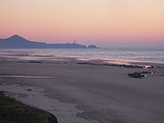
Moolack Beach is an undeveloped sandy beach
Beach
A beach is a geological landform along the shoreline of an ocean, sea, lake or river. It usually consists of loose particles which are often composed of rock, such as sand, gravel, shingle, pebbles or cobblestones...
on the Oregon Coast
Oregon Coast
The Oregon Coast is a region of the U.S. state of Oregon. It runs generally north-south along the Pacific Ocean, forming the western border of the state; the region is bounded to the east by the Oregon Coast Range. The Oregon Coast stretches approximately from the Columbia River in the north to...
about 4 miles (6 km) north of Newport
Newport, Oregon
Newport is a city in Lincoln County, Oregon, United States. It was incorporated in 1882, though the name dates back to the establishment of a post office in 1868...
in Lincoln County
Lincoln County, Oregon
-National protected areas:*Oregon Islands National Wildlife Refuge *Siletz Bay National Wildlife Refuge*Siuslaw National Forest -Demographics:...
, United States
United States
The United States of America is a federal constitutional republic comprising fifty states and a federal district...
. It is almost 8 km (5 mi) in length with the south end at Yaquina Head
Yaquina Head
Yaquina Head is a headland extending into the Pacific Ocean north of Newport, Oregon, United States. It is the site of the Yaquina Head Light, and is managed as Yaquina Head Outstanding Natural Area by the Bureau of Land Management....
and the north end at Otter Rock
Otter Rock, Oregon
Otter Rock is an unincorporated community in Lincoln County, Oregon, United States. It is located on U.S. Route 101 on the Oregon Coast.Otter Rock post office was established in 1913, and takes its name from a rock located about a half mile offshore and three and a quarter miles north of Yaquina Head...
, the site of Devils Punch Bowl State Natural Area
Devils Punch Bowl State Natural Area
Devils Punch Bowl State Natural Area is a state day use park on the central Oregon Coast in the United States. It is centered on a large bowl naturally carved in a rock headland which is partially open to the Pacific Ocean. Waves enter the bowl and often violently churn, swirl, and foam...
. The northern beach is the site of Beverly Beach State Park
Beverly Beach State Park
Beverly Beach State Park is a state park in the U.S. state of Oregon located north of Newport. It is a full R.V. hookup camping area with showers, bathrooms, beach access, and a meeting hall where evening interpretive programs take place. The park also has tent areas, as well as yurts for rent....
and the community of Beverly Beach
Beverly Beach, Oregon
Beverly Beach is an unincorporated community in Lincoln County in the U.S. state of Oregon. It is located on U.S. Route 101 on the Oregon Coast, north of Yaquina Head and south of Beverly Beach State Park....
. The beach has no obvious break delineating what would seem to be Beverly Beach, though Wade Creek is a likely candidate. The nearly ten foot (3 m) tidal range
Tidal range
The tidal range is the vertical difference between the high tide and the succeeding low tide. Tides are the rise and fall of sea levels caused by the combined effects of the gravitational forces exerted by the Moon and the Sun and the rotation of the Earth...
and seasonally-varying slope of the beach can cause the sandy beach to completely disappear at times; at other times it can be hundreds of feet wide. The beach is bounded by U.S. Route 101
U.S. Route 101 in Oregon
In the U.S. state of Oregon, U.S. Route 101, a major north–south U.S. Highway, runs through the state along the coastline near the Pacific Ocean. In Oregon, it runs from the Oregon–California border, south of Brookings, to the Oregon–Washington border on the Columbia River, between Astoria,...
.
The name is from an American Indian
Native Americans in the United States
Native Americans in the United States are the indigenous peoples in North America within the boundaries of the present-day continental United States, parts of Alaska, and the island state of Hawaii. They are composed of numerous, distinct tribes, states, and ethnic groups, many of which survive as...
word for "elk". The area is rich with geologic history.
Geology
The rooted stumps that remain likely belonged to trees living approximately 4,500 years ago. Several such stumps are visible at Moolack Beach. Among petrified woods common at Moolack Beach is Teredo wood, which is named for the signature Teredo clam-bored holes. Other petrified woods include pines and hardwoods, including alder, myrtlewoodUmbellularia
Umbellularia californica is a large tree native to coastal forests of California and slightly extended into Oregon.It is the sole species in the genus Umbellularia....
, and oak, as well as petrified palm.
Climate

External links
- ABC News "Outside Magazine's Top 10 Beach Getaways" 7. Oregon: Newport, South Beach State Park/Kite flying and Whale Watching
- 750 KXL Radio "Moolack Beach"