
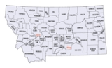
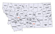
Montana census statistical areas
Encyclopedia
The United States Census Bureau
has defined three Metropolitan Statistical Areas (MSAs) and five Micropolitan Statistical Areas (USAs) in the State of Montana. The following table describes these areas with the following information:
United States Census Bureau
The United States Census Bureau is the government agency that is responsible for the United States Census. It also gathers other national demographic and economic data...
has defined three Metropolitan Statistical Areas (MSAs) and five Micropolitan Statistical Areas (USAs) in the State of Montana. The following table describes these areas with the following information:
- The name of the Core Based Statistical AreaCore based statistical areaA Core Based Statistical Area is a U.S. geographic area defined by the Office of Management and Budget based around an urban center of at least 10,000 people and adjacent areas that are socioeconomically tied to the urban center by commuting. Areas defined on the basis of these standards applied...
(CBSA). - The population of the CBSA as of 2006-07-01, as estimated by the United States Census Bureau.
- The name of the countyCounty (United States)In the United States, a county is a geographic subdivision of a state , usually assigned some governmental authority. The term "county" is used in 48 of the 50 states; Louisiana is divided into parishes and Alaska into boroughs. Parishes and boroughs are called "county-equivalents" by the U.S...
. - The population of the county as of 2006-07-01, as estimated by the United States Census Bureau.
| Core Based Statistical Area | 2006 Population | County | 2006 Population |
|---|---|---|---|
| Billings, MT MSA | 148,116 | Yellowstone County, Montana Yellowstone County, Montana -National protected areas:* Nez Perce National Historical Park * Pompeys Pillar National Monument-Demographics:As of the census of 2000, there were 129,352 people, 52,084 households, and 34,219 families residing in the county. The population density was 49 people per square mile . There were... |
138,213 |
| Carbon County, Montana Carbon County, Montana -National protected areas:* Bighorn Canyon National Recreation Area * Custer National Forest * Gallatin National Forest -Economy:During the early history of Carbon County, coal mining was the predominant industry... |
9,903 | ||
| Missoula, MT MSA | 101,417 | Missoula County, Montana Missoula County, Montana -National protected areas:*Bitterroot National Forest *Flathead National Forest *Lolo National Forest *Rattlesnake National Recreation Area-Demographics:... |
101,417 |
| Kalispell, MT USA | 85,314 | Flathead County, Montana Flathead County, Montana -National protected areas:* Pacific Northwest National Scenic Trail * Flathead National Forest * Glacier National Park * Kootenai National Forest * Lolo National Forest * Lost Trail National Wildlife Refuge-Demographics:... |
85,314 |
| Bozeman, MT USA | 80,921 | Gallatin County, Montana Gallatin County, Montana -National protected areas:* Gallatin National Forest * Yellowstone National Park -Demographics:As of the census of 2000, there were 67,831 people, 26,323 households, and 16,188 families residing in the county. The population density was 26 people per square mile . There were 29,489 housing units... |
80,921 |
| Great Falls, MT MSA | 79,385 | Cascade County, Montana Cascade County, Montana -National protected areas:*Benton Lake National Wildlife Refuge*Lewis and Clark National Forest -Economy:Malmstrom Air Force Base is a driving force in the regional economy... |
79,385 |
| Helena, MT USA | 70,558 | Lewis and Clark County, Montana Lewis and Clark County, Montana -National protected areas:* Flathead National Forest * Helena National Forest * Lewis and Clark National Forest * Lolo National Forest * Rocky Mountain Front Conservation Area -Demographics:... |
59,302 |
| Jefferson County, Montana Jefferson County, Montana -National protected areas:*Deerlodge National Forest *Helena National Forest -Demographics:As of the census of 2000, there were 10,049 people, 3,747 households, and 2,847 families residing in the county. The population density was 6 people per square mile . There were 4,199 housing units at an... |
11,256 | ||
| Butte-Silver Bow, MT USA | 32,801 | Silver Bow County, Montana Silver Bow County, Montana -National protected areas:*Beaverhead National Forest *Deerlodge National Forest -Demographics:As of the census of 2000, there were 34,606 people, 14,432 households, and 8,933 families residing in the county. The population density was 48 people per square mile . There were 16,176 housing units at... |
32,801 |
| Havre, MT USA | 16,403 | Hill County, Montana Hill County, Montana -National protected areas:*Creedman Coulee National Wildlife Refuge*Lake Thibadeau National Wildlife Refuge-Demographics:As of the census of 2000, there were 16,673 people, 6,457 households, and 4,255 families residing in the county. The population density was 6 people per square mile . There were... |
16,403 |
| none | Ravalli County, Montana Ravalli County, Montana -National protected areas:*Bitterroot National Forest *Lee Metcalf National Wildlife Refuge*Lolo National Forest -Demographics:As of the census of 2000 , there were 36,070 people, 14,289 households, and 10,188 families residing in the county. The population density was 15 people per square mile... |
40,582 | |
| Lake County, Montana Lake County, Montana -National protected areas:*Flathead National Forest *National Bison Range *Ninepipe National Wildlife Refuge*Pablo National Wildlife Refuge*Swan River National Wildlife Refuge-Demographics:... |
28,606 | ||
| Lincoln County, Montana Lincoln County, Montana -National protected areas:* Pacific Northwest National Scenic Trail *Flathead National Forest *Kaniksu National Forest *Kootenai National Forest -Demographics:... |
19,226 | ||
| Park County, Montana Park County, Montana Park Counties in Montana and Wyoming are among the very few pairs of counties in the United States with the same name to border each other across state lines.-National protected areas:* Custer National Forest * Gallatin National Forest... |
16,084 | ||
| Glacier County, Montana Glacier County, Montana -National protected areas:* Glacier National Park * Lewis and Clark National Forest -Demographics:As of the census of 2000, there were 13,247 people, 4,304 households, and 3,245 families residing in the county. The population density was 4 people per square mile . There were 5,243 housing units... |
13,578 | ||
| Big Horn County, Montana Big Horn County, Montana - National protected areas :* Bighorn Canyon National Recreation Area * Little Bighorn Battlefield National Monument- Economy :Coal Mining and Agriculture both play major roles in Big Horn County’s economy... |
13,035 | ||
| Fergus County, Montana Fergus County, Montana -National protected areas:* Charles M. Russell National Wildlife Refuge * Lewis and Clark National Forest * Upper Missouri River Breaks National Monument -Demographics:... |
11,496 | ||
| Custer County, Montana Custer County, Montana -Economy:The main source of income for Custer County has largely come from cattle ranching and dryland farming. Miles City serves as the center of commerce in an area extending for 100 miles in every direction... |
11,151 | ||
| Sanders County, Montana Sanders County, Montana Sanders County is a county located in the U.S. state of Montana. As of 2010, the population was 11,413. Its county seat is Thompson Falls.-Geography:According to the U.S... |
11,138 | ||
| Roosevelt County, Montana Roosevelt County, Montana -National protected areas:* Fort Union Trading Post National Historic Site * Medicine Lake National Wildlife Refuge -Demographics:As of the census of 2000, there were 10,620 people, 3,581 households, and 2,614 families residing in the county. The population density was 4 people per square mile... |
10,496 | ||
| Richland County, Montana Richland County, Montana -Demographics:As of the census of 2000, there were 9,667 people, 3,878 households, and 2,652 families residing in the county. The population density was 5 people per square mile . There were 4,557 housing units at an average density of 2 per square mile... |
9,295 | ||
| Rosebud County, Montana Rosebud County, Montana -Demographics:As of the census of 2000, there were 9,383 people, 3,307 households, and 2,417 families residing in the county. The population density was 2 people per square mile . There were 3,912 housing units at an average density of 1 per square mile... |
9,261 | ||
| Deer Lodge County, Montana Deer Lodge County, Montana -National protected areas:*Beaverhead National Forest *Deerlodge National Forest -Demographics:As of the census of 2000, there were 9,417 people, 3,995 households, and 2,524 families residing in the county. The population density was 13 people per square mile . There were 4,958 housing units at an... |
8,888 | ||
| Beaverhead County, Montana Beaverhead County, Montana -National protected areas:* Beaverhead National Forest * Big Hole National Battlefield* Nez Perce National Historical Park * Red Rock Lakes National Wildlife Refuge-History:... |
8,743 | ||
| Stillwater County, Montana Stillwater County, Montana -National protected areas:*Custer National Forest *Hailstone National Wildlife Refuge*Halfbreed Lake National Wildlife Refuge-Demographics:... |
8,646 | ||
| Dawson County, Montana Dawson County, Montana -Economy:Dawson County is known for its dryland grain, coal mines and gas and oil wells. There are 522 current farms and ranches, and 296 commercial businesses.-Demographics:... |
8,624 | ||
| Madison County, Montana Madison County, Montana -National protected areas:*Beaverhead National Forest *Deerlodge National Forest *Gallatin National Forest -Demographics:As of the census of 2000, there were 6,851 people, 2,956 households, and 1,921 families residing in the county. The population density was 2 people per square mile... |
7,404 | ||
| Powell County, Montana Powell County, Montana -National protected areas:* Beaverhead-Deerlodge National Forest * Flathead National Forest * Grant-Kohrs Ranch National Historic Site* Helena National Forest * Lolo National Forest * Bob Marshall Wilderness Area... |
6,997 | ||
| Valley County, Montana Valley County, Montana -Demographics:As of the census of 2000, there were 7,675 people, 3,150 households, and 2,129 families residing in the county. The population density was 2 people per square mile . There were 4,847 housing units at an average density of 1 per square mile... |
6,995 | ||
| Blaine County, Montana Blaine County, Montana -National protected areas:* Black Coulee National Wildlife Refuge* Nez Perce National Historical Park * Upper Missouri River Breaks National Monument -Economy:The main industry in Blaine County is Agriculture... |
6,615 | ||
| Teton County, Montana Teton County, Montana -National protected area:*Lewis and Clark National Forest *Rocky Mountain Front Conservation Area -Demographics:As of the census of 2000, there were 6,445 people, 2,538 households, and 1,761 families residing in the county. The population density was 3 people per square mile . There were 2,910... |
6,115 | ||
| Pondera County, Montana Pondera County, Montana -National protected area:*Lewis and Clark National Forest *Rocky Mountain Front Conservation Area -Demographics:As of the census of 2000, there were 6,424 people, 2,410 households, and 1,740 families residing in the county. The population density was 4 people per square mile . There were 2,834... |
6,032 | ||
| Chouteau County, Montana Chouteau County, Montana -National protected areas:* Lewis and Clark National Forest * Upper Missouri River Breaks National Monument -Economy:Chouteau County is the largest winter wheat producer for the state of Montana... |
5,417 | ||
| Toole County, Montana Toole County, Montana -Demographics:As of the census of 2000, there were 5,267 people, 1,962 households, and 1,308 families residing in the county. The population density was 3 people per square mile . There were 2,300 housing units at an average density of 1 per square mile... |
5,073 | ||
| Musselshell County, Montana Musselshell County, Montana -Demographics:As of the census of 2000, there are 4,497 people, 1,878 households, and 1,235 families residing in the county. The population density is 2 people per square mile . There are 2,317 housing units at an average density of -Demographics:... |
4,586 | ||
| Broadwater County, Montana Broadwater County, Montana -Economy:Agriculture is one of the primary industries in Broadwater County. RY Timber and Wheat Montana Bakery were the largest private employers according to the 2000 Census.-Demographics:... |
4,572 | ||
| Phillips County, Montana Phillips County, Montana -National protected areas:* Bowdoin National Wildlife Refuge* Charles M. Russell National Wildlife Refuge * Hewitt Lake National Wildlife Refuge* UL Bend National Wildlife Refuge* Upper Missouri River Breaks National Monument -Demographics:... |
4,098 | ||
| Mineral County, Montana Mineral County, Montana -Demographics:As of the census of 2000, there were 3,884 people, 1,584 households, and 1,067 families residing in the county. The population density was 3 people per square mile . There were 1,961 housing units at an average density of 2 per square mile... |
4,057 | ||
| Sweet Grass County, Montana Sweet Grass County, Montana -National protected areas:*Custer National Forest *Gallatin National Forest *Lewis and Clark National Forest -Demographics:As of the census of 2000, there were 3,609 people, 1,476 households, and 987 families residing in the county. The population density was 2 people per square mile... |
3,760 | ||
| Sheridan County, Montana Sheridan County, Montana -Demographics:As of the census of 2000, there were 4,105 people, 1,741 households, and 1,140 families residing in the county. The population density was 2.4 people per square mile . There were 2,167 housing units at an average density of 1.3 per square mile... |
3,447 | ||
| Granite County, Montana Granite County, Montana -National protected areas:*Deerlodge National Forest *Lolo National Forest -Demographics:As of the census of 2000, there were 2,830 people, 1,200 households, and 784 families residing in the county. The population density was 2 people per square mile . There were 2,074 housing units at an average... |
2,909 | ||
| Fallon County, Montana Fallon County, Montana Fallon County is a county located in the U.S. state of Montana. As of 2010, the population was 2,890. Its county seat is Baker.Fallon County was created in 1913 after being carved out of Custer County. The name comes from Benjamin O'Fallon, a nephew of Captain William Clark and an Indian agent... |
2,717 | ||
| Judith Basin County, Montana Judith Basin County, Montana -Demographics:As of the census of 2000, there were 2,329 people, 951 households, and 661 families residing in the county. The population density was -Demographics:... |
2,142 | ||
| Meagher County, Montana Meagher County, Montana -National protected areas:*Gallatin National Forest *Helena National Forest *Lewis and Clark National Forest -Demographics:As of the census of 2000, there were 1,932 people, 803 households, and 529 families residing in the county... |
1,968 | ||
| Wheatland County, Montana Wheatland County, Montana -Demographics:As of the census of 2000, there were 2,259 people, 853 households, and 540 families residing in the county. The population density was 2 people per square mile . There were 1,154 housing units at an average density of 1 per square mile... |
1,959 | ||
| Liberty County, Montana Liberty County, Montana -Demographics:As of the census of 2000, there were 2,158 people, 833 households, and 583 families residing in the county. The population density was 2 people per square mile . There were 1,070 housing units at an average density of 1 per square mile... |
1,863 | ||
| Daniels County, Montana Daniels County, Montana -Economy:The main source of income for Daniels County has been cattle and dryland wheat.-Demographics:As of the census of 2000, there were 2,017 people, 892 households, and 561 families residing in the county. The population density was 1.4 people per square mile . There were 1,154 housing units... |
1,774 | ||
| McCone County, Montana McCone County, Montana -Demographics:As of the census of 2000, there were 1,977 people, 810 households, and 596 families residing in the county. The population density was 1 people per square mile . There were 1,087 housing units at an average density of 0 per square mile... |
1,760 | ||
| Powder River County, Montana Powder River County, Montana -Demographics:As of the census of 2000, there were 1,858 people, 737 households, and 524 families residing in the county. The population density was -Demographics:... |
1,756 | ||
| Carter County, Montana Carter County, Montana -Demographics:As of the census of 2000, there were 1,360 people, 543 households, and 382 families residing in the county. The population density was -Demographics:... |
1,321 | ||
| Garfield County, Montana Garfield County, Montana -Politics:Garfield County is a solidly Republican county. It might be the most Republican county in Montana and one of the most Republican in the nation.... |
1,244 | ||
| Golden Valley County, Montana Golden Valley County, Montana -Demographics:As of the census of 2000, there were 1,042 people, 365 households, and 263 families residing in the county. The population density was -Demographics:... |
1,150 | ||
| Prairie County, Montana Prairie County, Montana -Demographics:As of the census of 2000, there were 1,199 people, 537 households, and 354 families residing in the county. The population density was -Demographics:... |
1,074 | ||
| Wibaux County, Montana Wibaux County, Montana -Demographics:As of the census of 2000, there were 1,068 people, 421 households, and 287 families residing in the county. The population density was less than 1 person per square mile . There were 587 housing units at an average density of less than 1/sq mi... |
909 | ||
| Treasure County, Montana Treasure County, Montana - Demographics :As of the census of 2000, there were 861 people, 357 households, and 242 families residing in the county. The population density was - Demographics :... |
680 | ||
| Petroleum County, Montana Petroleum County, Montana -National protected areas:*Charles M. Russell National Wildlife Refuge *War Horse National Wildlife Refuge-Demographics:At the 2000 census, there were 493 people, 211 households and 136 families residing in the county. The population density was 0.29 per square mile . There were 292 housing units... |
474 | ||
See also
- State of Montana
- Demographics of Montana
- Geography of Montana
- United StatesUnited StatesThe United States of America is a federal constitutional republic comprising fifty states and a federal district...
- United States Census BureauUnited States Census BureauThe United States Census Bureau is the government agency that is responsible for the United States Census. It also gathers other national demographic and economic data...
- Table of United States Combined Statistical AreasTable of United States Combined Statistical Areasthumb|An enlargeable map of the 125 [[Combined Statistical Area]]s of the [[United States]]The United States Office of Management and Budget has defined 125 Combined Statistical Areas for the United States of America...
(CSA) - Table of United States Core Based Statistical Areas (CBSA)
- Table of United States Metropolitan Statistical AreasTable of United States Metropolitan Statistical Areasthumb|An enlargeable map of the 942 [[Core Based Statistical Area]]s of the [[United States]]. The 367 [[Metropolitan Statistical Area]]s are shown in red....
(MSA) - Table of United States Micropolitan Statistical AreasTable of United States Micropolitan Statistical Areasthumb|An enlargeable map of the 942 [[Core Based Statistical Area]]s of the [[United States]]. The 576 [[Micropolitan Statistical Area]]s are shown in blue....
(USA) - Table of United States primary census statistical areas (PCSA)
- Table of United States Combined Statistical Areas
- United States Census Bureau