

Mokulele Highway
Encyclopedia
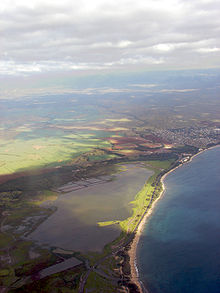
Mokulele Highway is a highway on Maui that connects Kahului with Kihei
, covering the distance of approximately 7 miles (11.3 km). Most of the highway cuts through the valley-like isthmus
of Maui surrounded by sugarcane fields
on both sides of the road.
Mokulele begins as a continuation of Puunene Road South, leaving Kahului. It then passes through what is known as the "Puunene" area of Maui, and continues as Mokulele, designated as Route 311 and 350 combined.
The Highway continues South from agricultural land and as it nears the Kealia Pond
area, it intersects the Piilani Highway, ending shortly after at its junction with South Kehei Road, just to the north side of Kihei.
Kihei, Hawaii
Kīhei is a census-designated place in Maui County, Hawaii, United States. The population was 16,749 at the 2000 census.-Geography:Kīhei is located at ....
, covering the distance of approximately 7 miles (11.3 km). Most of the highway cuts through the valley-like isthmus
Isthmus
An isthmus is a narrow strip of land connecting two larger land areas usually with waterforms on either side.Canals are often built through isthmuses where they may be particularly advantageous to create a shortcut for marine transportation...
of Maui surrounded by sugarcane fields
Sugar plantations in Hawaii
Sugarcane was introduced to Hawaii by its first inhabitants in approximately 600 AD and was observed by Captain Cook upon arrival in the islands in 1778. Sugar quickly turned into a big business and generated rapid population growth in the islands with 337,000 people immigrating over the span of a...
on both sides of the road.
Mokulele begins as a continuation of Puunene Road South, leaving Kahului. It then passes through what is known as the "Puunene" area of Maui, and continues as Mokulele, designated as Route 311 and 350 combined.
The Highway continues South from agricultural land and as it nears the Kealia Pond
Kealia Pond National Wildlife Refuge
-External links:***...
area, it intersects the Piilani Highway, ending shortly after at its junction with South Kehei Road, just to the north side of Kihei.