

Moapa Valley, Nevada
Encyclopedia
Moapa Valley is an unincorporated town
in Clark County
, Nevada
, United States
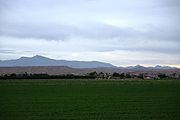
. The valley in which the community lies, also named Moapa Valley, is about 40 miles (64.4 km) long and lies roughly northwest to southeast.
, formerly called the Moapa River, originates from the Warm Springs Natural Area, and flows through the valley before emptying into Lake Mead
. The towns of Moapa, Logandale
and Overton
are located in the valley. Logandale is about 12 miles (19.3 km) southeast of Moapa and Overton is about 5 miles (8 km) southeast of Logandale. Prior to the creation of Lake Mead, Moapa Valley also included the town of St. Thomas
, which was abandoned in 1938 due to the rising lake level. The population was 5,784 at the 2000 census
.
 Moapa Valley is at an elevation of 1265 ft (385.6 m) above sea level. The United States Census Bureau
gives the census-designated place
(CDP) of Moapa Valley (which may not coincide exactly with the town boundaries) a total area of 43.7 square miles (113.2 km²), of which, 43.6 square miles (112.9 km²) of it is land and 0.1 square mile (0.258998811 km²) of it (0.30%) is water.
of 2000, there were 5,784 people, 1,934 households, and 1,525 families residing in the CDP. The population density
was 132.7 people per square mile (51.3/km²). There were 2,213 housing units at an average density of 50.8 per square mile (19.6/km²). The racial makeup of the CDP was 92.41% White, 0.24% African American, 0.66% Native American, 0.26% Asian, 0.36% Pacific Islander, 4.34% from other races
, and 1.73% from two or more races. Hispanic or Latino of any race were 9.09% of the population.
There were 1,934 households out of which 38.8% had children under the age of 18 living with them, 69.8% were married couples
living together, 6.5% had a female householder with no husband present, and 21.1% were non-families. 17.8% of all households were made up of individuals and 10.4% had someone living alone who was 65 years of age or older. The average household size was 2.99 and the average family size was 3.43.
In the CDP the population was spread out with 33.5% under the age of 18, 6.7% from 18 to 24, 23.0% from 25 to 44, 21.6% from 45 to 64, and 15.2% who were 65 years of age or older. The median age was 36 years. For every 100 females there were 101.7 males. For every 100 females age 18 and over, there were 98.2 males.
The median income for a household in the CDP was $39,942, and the median income for a family was $47,575. Males had a median income of $42,348 versus $26,442 for females. The per capita income
for the CDP was $16,696. About 5.7% of families and 6.9% of the population were below the poverty line, including 7.3% of those under age 18 and 8.3% of those age 65 or over.
". It was also around this time that the art of pottery was introduced. By 600 A.D. the people, now known as "Puebloans"
, began building their dwellings above ground, using wood and brush plastered with Adobe
. Farming was a well-established practice with corn, beans, squash, and cotton being the primary crops. The Puebloans also hunted Mule deer
, desert big horn sheep
, rabbits, and rodents using the bow and arrow.
Around 1000 A.D. Southern Paiutes moved into the Moapa Valley area. The Paiutes were hunter-gatherer
s who did not utilize agriculture as a primary source of subsistence. They lived in temporary brush dwellings, spoke the Southern Paiute language, and practiced a style of pottery
that was less sophisticated to the methods used by the Anasazi. The Paiutes and Anasazi people coexisted with little effort in the valley.
Sometime around 1150 A.D., the Anasazi abandoned Moapa Valley possibly due to a drought
which gripped the Desert Southwest during that time. When the first European settlers arrived, the Paiutes were relocated to a reservation north of Moapa
where they continue to live today.
has thirteen wards.
104.7 has a MOR format. KQLL
has simulcast on of Henderson, Nevada's 1280 AM on 102.3 FM, with is a News/Talk format.
Unincorporated towns in Nevada
Nevada state law allows for governance of unincorporated towns under two different systems. The Unincorporated Town Government Law, adopted in 1975, applies to counties of 100,000 people or more, and any other county that opts in...
in Clark County
Clark County, Nevada
-Demographics:As of the census of 2000, there were 1,375,765 people, 512,253 households, and 339,693 families residing within the MSA. The racial makeup of the MSA was 71.6% White , 9.1% Black, 5.7% Asian, 0.8% American Indian and 12.8% of other or mixed race. 22.0% were Hispanic of any race...
, Nevada
Nevada
Nevada is a state in the western, mountain west, and southwestern regions of the United States. With an area of and a population of about 2.7 million, it is the 7th-largest and 35th-most populous state. Over two-thirds of Nevada's people live in the Las Vegas metropolitan area, which contains its...
, United States
United States
The United States of America is a federal constitutional republic comprising fifty states and a federal district...
. The valley in which the community lies, also named Moapa Valley, is about 40 miles (64.4 km) long and lies roughly northwest to southeast.
Geography
The Muddy RiverMuddy River
The Muddy River, formerly known as the Moapa River, is a short river located in the southern part of the state in Clark County, Nevada, United States. It is in the Mojave Desert, approximately 60 miles north of Las Vegas.-Geography:...
, formerly called the Moapa River, originates from the Warm Springs Natural Area, and flows through the valley before emptying into Lake Mead
Lake Mead
Lake Mead is the largest reservoir in the United States. It is located on the Colorado River about southeast of Las Vegas, Nevada, in the states of Nevada and Arizona. Formed by water impounded by the Hoover Dam, it extends behind the dam, holding approximately of water.-History:The lake was...
. The towns of Moapa, Logandale
Logandale, Nevada
Logandale is an unincorporated town located in Clark County, Nevada. The community is the home of the annual Clark County Fair and Rodeo. It began as a railroad station in 1912. It was originally named Logan but renamed to avoid confusion with Logan, Utah....
and Overton
Overton, Nevada
Overton is an Unincorporated Town located in Clark County, Nevada. The town is on the north end of Lake Mead. The town is home to Perkins Field airport and Echo Bay Airport....
are located in the valley. Logandale is about 12 miles (19.3 km) southeast of Moapa and Overton is about 5 miles (8 km) southeast of Logandale. Prior to the creation of Lake Mead, Moapa Valley also included the town of St. Thomas
St. Thomas, Nevada
St. Thomas, Nevada, is a ghost town in Clark County, Nevada, near where the Muddy River flows into the Colorado River. St. Thomas was purchased by the US Federal Government and abandoned as the waters of Lake Mead submerged the town. It is now located within the Lake Mead National Recreation...
, which was abandoned in 1938 due to the rising lake level. The population was 5,784 at the 2000 census
United States Census, 2000
The Twenty-second United States Census, known as Census 2000 and conducted by the Census Bureau, determined the resident population of the United States on April 1, 2000, to be 281,421,906, an increase of 13.2% over the 248,709,873 persons enumerated during the 1990 Census...
.
United States Census Bureau
The United States Census Bureau is the government agency that is responsible for the United States Census. It also gathers other national demographic and economic data...
gives the census-designated place
Census-designated place
A census-designated place is a concentration of population identified by the United States Census Bureau for statistical purposes. CDPs are delineated for each decennial census as the statistical counterparts of incorporated places such as cities, towns and villages...
(CDP) of Moapa Valley (which may not coincide exactly with the town boundaries) a total area of 43.7 square miles (113.2 km²), of which, 43.6 square miles (112.9 km²) of it is land and 0.1 square mile (0.258998811 km²) of it (0.30%) is water.
Demographics
As of the censusCensus
A census is the procedure of systematically acquiring and recording information about the members of a given population. It is a regularly occurring and official count of a particular population. The term is used mostly in connection with national population and housing censuses; other common...
of 2000, there were 5,784 people, 1,934 households, and 1,525 families residing in the CDP. The population density
Population density
Population density is a measurement of population per unit area or unit volume. It is frequently applied to living organisms, and particularly to humans...
was 132.7 people per square mile (51.3/km²). There were 2,213 housing units at an average density of 50.8 per square mile (19.6/km²). The racial makeup of the CDP was 92.41% White, 0.24% African American, 0.66% Native American, 0.26% Asian, 0.36% Pacific Islander, 4.34% from other races
Race (United States Census)
Race and ethnicity in the United States Census, as defined by the Federal Office of Management and Budget and the United States Census Bureau, are self-identification data items in which residents choose the race or races with which they most closely identify, and indicate whether or not they are...
, and 1.73% from two or more races. Hispanic or Latino of any race were 9.09% of the population.
There were 1,934 households out of which 38.8% had children under the age of 18 living with them, 69.8% were married couples
Marriage
Marriage is a social union or legal contract between people that creates kinship. It is an institution in which interpersonal relationships, usually intimate and sexual, are acknowledged in a variety of ways, depending on the culture or subculture in which it is found...
living together, 6.5% had a female householder with no husband present, and 21.1% were non-families. 17.8% of all households were made up of individuals and 10.4% had someone living alone who was 65 years of age or older. The average household size was 2.99 and the average family size was 3.43.
In the CDP the population was spread out with 33.5% under the age of 18, 6.7% from 18 to 24, 23.0% from 25 to 44, 21.6% from 45 to 64, and 15.2% who were 65 years of age or older. The median age was 36 years. For every 100 females there were 101.7 males. For every 100 females age 18 and over, there were 98.2 males.
The median income for a household in the CDP was $39,942, and the median income for a family was $47,575. Males had a median income of $42,348 versus $26,442 for females. The per capita income
Per capita income
Per capita income or income per person is a measure of mean income within an economic aggregate, such as a country or city. It is calculated by taking a measure of all sources of income in the aggregate and dividing it by the total population...
for the CDP was $16,696. About 5.7% of families and 6.9% of the population were below the poverty line, including 7.3% of those under age 18 and 8.3% of those age 65 or over.
Native American
The Moapa Valley was originally settled by the Anasazi people around 350 B.C. Around 500 A.D., farming supplanted hunting as the major food source for the people known as "BasketmakersBasketmaker (culture)
The Basketmaker culture of the Ancient Pueblo People began about 1500 BC and continued until about AD 500 with the beginning of the Pueblo I Era...
". It was also around this time that the art of pottery was introduced. By 600 A.D. the people, now known as "Puebloans"
Ancient Pueblo Peoples
Ancient Pueblo People or Ancestral Pueblo peoples were an ancient Native American culture centered on the present-day Four Corners area of the United States, comprising southern Utah, northern Arizona, northwest New Mexico, and southern Colorado...
, began building their dwellings above ground, using wood and brush plastered with Adobe
Adobe
Adobe is a natural building material made from sand, clay, water, and some kind of fibrous or organic material , which the builders shape into bricks using frames and dry in the sun. Adobe buildings are similar to cob and mudbrick buildings. Adobe structures are extremely durable, and account for...
. Farming was a well-established practice with corn, beans, squash, and cotton being the primary crops. The Puebloans also hunted Mule deer
Mule Deer
The mule deer is a deer indigenous to western North America. The Mule Deer gets its name from its large mule-like ears. There are believed to be several subspecies, including the black-tailed deer...
, desert big horn sheep
Desert Bighorn Sheep
The Desert Bighorn Sheep is a subspecies of Bighorn Sheep that occurs in the desert Southwest regions of the United States and in the northern regions of Mexico. The trinomial of this species commemorates the American naturalist Edward William Nelson...
, rabbits, and rodents using the bow and arrow.
Around 1000 A.D. Southern Paiutes moved into the Moapa Valley area. The Paiutes were hunter-gatherer
Hunter-gatherer
A hunter-gatherer or forage society is one in which most or all food is obtained from wild plants and animals, in contrast to agricultural societies which rely mainly on domesticated species. Hunting and gathering was the ancestral subsistence mode of Homo, and all modern humans were...
s who did not utilize agriculture as a primary source of subsistence. They lived in temporary brush dwellings, spoke the Southern Paiute language, and practiced a style of pottery
Pottery
Pottery is the material from which the potteryware is made, of which major types include earthenware, stoneware and porcelain. The place where such wares are made is also called a pottery . Pottery also refers to the art or craft of the potter or the manufacture of pottery...
that was less sophisticated to the methods used by the Anasazi. The Paiutes and Anasazi people coexisted with little effort in the valley.
Sometime around 1150 A.D., the Anasazi abandoned Moapa Valley possibly due to a drought
Drought
A drought is an extended period of months or years when a region notes a deficiency in its water supply. Generally, this occurs when a region receives consistently below average precipitation. It can have a substantial impact on the ecosystem and agriculture of the affected region...
which gripped the Desert Southwest during that time. When the first European settlers arrived, the Paiutes were relocated to a reservation north of Moapa
Moapa Town, Nevada
Moapa Town is a census-designated place in Clark County, Nevada, United States. The population was 928 at the 2000 census. It is the largest town in Clark County by land area...
where they continue to live today.
Settlers
The first Euroamerican settlers in the Moapa Valley were Mormon pioneers in the latter 1880s. The area has remained heavily populated by Mormons to present time. Many streets bear the names of prominent Mormon families (e.g. Barlow, Hinckley, Leavitt, Lyman, Perkins http://www.1st100.com/part1/perkins.html, Whitmore, Wells, and Andersen). The LDS Logandale StakeStake (Mormonism)
A stake is an administrative unit composed of multiple congregations in denominations of the Latter Day Saint movement. A stake is approximately comparable to a diocese in the Catholic Church and other Christian denominations...
has thirteen wards.
Radio stations
There are four radio stations licensed to Moapa Valley. KRRN 92.7 has a Spanish format. KXLI 94.5 has a dance format mainly targeted to Las Vegas. KJULKjul
Kjul is a village in Akershus, Norway....
104.7 has a MOR format. KQLL
KQLL
KTGX is a radio station broadcasting an 90's Hits format.Before KTGX launched on December 28, 2009, the station took the call signs KQLL-FM "KOOL 106.1." From October 30 until December 28, the station stunted with Christmas music under the "Christmas 106" branding. Before that, the station...
has simulcast on of Henderson, Nevada's 1280 AM on 102.3 FM, with is a News/Talk format.