

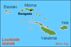
Misima Island
Encyclopedia
Louisiade Archipelago
The Louisiade Archipelago is a string of ten larger volcanic islands frequently fringed by coral reefs, and 90 smaller coral islands located 200 km southeast of New Guinea, stretching over more than and spread over an ocean area of between the Solomon Sea to the north and the Coral Sea to...
within Milne Bay Province
Milne Bay Province
Milne Bay is a province of Papua New Guinea. Its capital is Alotau. The province covers 14,000 km² of land and 252,990 km² of sea, within the province there are more than 600 islands, about 160 of which are inhabited...
of Papua New Guinea
Papua New Guinea
Papua New Guinea , officially the Independent State of Papua New Guinea, is a country in Oceania, occupying the eastern half of the island of New Guinea and numerous offshore islands...
. The island measures 40 km by 10 km and has an area of 202,5 km². It is located some 20 km north of the northwest extreme of the barrier reef of Vanatinai
Vanatinai
Vanatinai or Tagula is a volcanic island in the south-east of the Louisiade Archipelago within Milne Bay Province of Papua New Guinea. The reef fringed island is approximately south-east of New Guinea. With an area of , it is the largest island of the archipelago. Vanatinai town, the main...
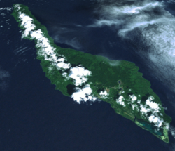
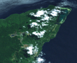
at Isu Raua Raua Island, and 80 km northwest of Vanatinai Island itself. Misima is mountainous and densely forested. Mt. Koia Tau, at a height of 1,036 meters, is the highest peak of the Louisiade Archipelago.
With a population of 5,000, Misima is the most heavily populated island in the archipelago
Archipelago
An archipelago , sometimes called an island group, is a chain or cluster of islands. The word archipelago is derived from the Greek ἄρχι- – arkhi- and πέλαγος – pélagos through the Italian arcipelago...
. By area, it is the third largest, after Vanatinai
Vanatinai
Vanatinai or Tagula is a volcanic island in the south-east of the Louisiade Archipelago within Milne Bay Province of Papua New Guinea. The reef fringed island is approximately south-east of New Guinea. With an area of , it is the largest island of the archipelago. Vanatinai town, the main...
and Rossel Island. A gold and silver mine was opened on the island in 1990 and officially closed in 2004. The mine was a joint venture by Placer Dome Inc (owning 80%) and the state-owned Orogen Minerals Ltd. The main town of the island and the seat of the district is Bwagaoia, located on the southeast corner of the island. Other villages are Hinauta, Boiou, Gulewa, Liak, Sagarai, Eiaus (on the eastern north coast, reachable by road from Bwagaoia), Gulewa and Ewena or Ewana (on the western north coast), and Bwagabwaga and Alhoga (on the south coast).
Misima has a working airport (two flights weekly to the mainland), a high school (grades 7-10), a small market, a few small stores and a clinic/hospital--all of which are located in Bwagaoia.
The main language of the island is also called Misiman
Misima-Paneati language
Misima-Paneati, also called Misiman, is an indigenous Austronesian language spoken on the islands of Misima, Panaieti, and the islands of the eastern half of the Calvados Chain of Papua New Guinea.- Vowels :Misima-Paneati has 5 vowel phonemes....
, though many residents speak Tok Pisin (pidgin) and also English, as a third language.