

Minot micropolitan area
Encyclopedia
United States Census Bureau
The United States Census Bureau is the government agency that is responsible for the United States Census. It also gathers other national demographic and economic data...
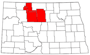
, is an area consisting of three counties in North Dakota
North Dakota
North Dakota is a state located in the Midwestern region of the United States of America, along the Canadian border. The state is bordered by Canada to the north, Minnesota to the east, South Dakota to the south and Montana to the west. North Dakota is the 19th-largest state by area in the U.S....
, anchored by the city of Minot
Minot, North Dakota
Minot is a city located in north central North Dakota in the United States. It is most widely known for the Air Force base located approximately 15 miles north of the city. With a population of 40,888 at the 2010 census, Minot is the fourth largest city in the state...
. As of the 2010 census
United States Census, 2010
The Twenty-third United States Census, known as Census 2010 or the 2010 Census, is the current national census of the United States. National Census Day was April 1, 2010 and is the reference date used in enumerating individuals...
, the μSA had a population of 69,540.
Counties
- McHenryMcHenry County, North Dakota-National protected areas:*Cottonwood Lake National Wildlife Refuge*J. Clark Salyer National Wildlife Refuge *Wintering River National Wildlife Refuge-Demographics:...
- RenvilleRenville County, North Dakota-Demographics:As of the census of 2000, there were 2,610 people, 1,085 households, and 748 families residing in the county. The population density was 3 people per square mile . There were 1,413 housing units at an average density of 2 per square mile...
- WardWard County, North Dakota-National protected areas:*Des Lacs National Wildlife Refuge *Hiddenwood National Wildlife Refuge *Upper Souris National Wildlife Refuge -Demographics:...
Places with 1,000 to 10,000 inhabitants
- BurlingtonBurlington, North DakotaBurlington is a city in Ward County, North Dakota in the United States. Burlington was founded in 1883, having been third in a series that included two earlier settlements. Despite this, Burlington is still the oldest city in Ward County, as well as north-western and north central North Dakota...
- KenmareKenmare, North DakotaAs of the census of 2000, there were 1,081 people, 468 households, and 278 families residing in the city. The population density was 872.8 people per square mile . There were 553 housing units at an average density of 446.5 per square mile...
- Minot Air Force BaseMinot Air Force BaseMinot Air Force Base is a U.S. Air Force installation in Ward County, North Dakota, north of the city of Minot. In the 2010 census, the base was counted as a CDP with a total population of 5,521....
(census-designated placeCensus-designated placeA census-designated place is a concentration of population identified by the United States Census Bureau for statistical purposes. CDPs are delineated for each decennial census as the statistical counterparts of incorporated places such as cities, towns and villages...
) - VelvaVelva, North DakotaAs of the census of 2000, there were 1,049 people, 436 households, and 275 families residing in the city. The population density was 1,359.7 people per square mile . There were 483 housing units at an average density of 626.1 per square mile . The racial makeup of the city was 99.33% White, 0.10%...
Places with 100 to 1,000 inhabitants
|
Karlsruhe, North Dakota -External links:*... Makoti, North Dakota As of the census of 2000, there were 145 people, 74 households, and 35 families residing in the city. The population density was 733.3 people per square mile . There were 89 housing units at an average density of 450.1 per square mile... Mohall, North Dakota At the 2000 census, there were 812 people, 340 households and 214 families residing in the city. The population density was 747.9 per square mile . There were 397 housing units at an average density of 365.6 per square mile . The racial makeup of the city was 98.40% White, 0.74% Native American,... Sawyer, North Dakota As of the census of 2000, there were 377 people, 150 households, and 108 families residing in the city. The population density was 782.4 people per square mile . There were 162 housing units at an average density of 336.2 per square mile . The racial makeup of the city was 98.14% White, 0.53%... Sherwood, North Dakota As of the census of 2000, there were 255 people, 117 households, and 65 families residing in the city. The population density was 802.2 people per square mile . There were 138 housing units at an average density of 434.1 per square mile... Surrey, North Dakota As of the census of 2000, there were 917 people, 307 households, and 260 families residing in the city. The population density was 943.1 people per square mile . There were 313 housing units at an average density of 321.9 per square mile . The racial makeup of the city was 97.27% White, 1.85%... Towner, North Dakota As of the census of 2000, there were 574 people, 295 households, and 158 families residing in the city. The population density was 694.0 people per square mile . There were 335 housing units at an average density of 405.0 per square mile . The racial makeup of the city was 97.91% White, 0.35%... Upham, North Dakota As of the census of 2000, there were 155 people, 81 households, and 40 families residing in the city. The population density was 479.4 people per square mile . There were 120 housing units at an average density of 371.1 per square mile... |
Places with less than 100 inhabitants
- BalfourBalfour, North DakotaAs of the census of 2000, there were 20 people, 14 households, and 6 families residing in the city. The population density was 41.2 people per square mile . There were 21 housing units at an average density of 43.2 per square mile . The racial makeup of the city was 100.00% White...
- BantryBantry, North DakotaAs of the census of 2000, there were 19 people, 11 households, and 4 families residing in the city. The population density was 115.6 people per square mile . There were 11 housing units at an average density of 66.9 per square mile...
- BergenBergen, North DakotaAs of the census of 2000, there were 11 people, 4 households, and 3 families residing in the city. The population density was 15.4 people per square mile . There were 11 housing units at an average density of 15.4 per square mile...
- DonnybrookDonnybrook, North DakotaAs of the census of 2000, there were 90 people, 36 households, and 28 families residing in the city. The population density was 128.5 people per square mile . There were 46 housing units at an average density of 65.7 per square mile . The racial makeup of the city was 95.56% White, 4.44% from other...
- DouglasDouglas, North DakotaAs of the census of 2000, there were 64 people, 30 households, and 17 families residing in the city. The population density was 223.1 people per square mile . There were 44 housing units at an average density of 153.4 per square mile . The racial makeup of the city was 93.75% White and 6.25% Native...
- GranoGrano, North DakotaAs of the census of 2000, there were 9 people, 5 households, and 3 families residing in the city. The population density was 30.2 people per square mile . There were 5 housing units at an average density of 16.8 per square mile...
- KiefKief, North DakotaAs of the 2000 Census, there were 13 people, 8 households, and 3 families residing in the city. The population density was 10.7 people per square mile . There were 18 housing units at an average density of 14.8 per square mile...
- LoraineLoraine, North DakotaAs of the census of 2000, there were 19 people, 8 households, and 5 families residing in the city. The population density was 78.7 people per square mile . There were 8 housing units at an average density of 33.1 per square mile...
- RyderRyder, North DakotaAs of the census of 2000, there were 92 people, 44 households, and 23 families residing in the city. The population density was 282.9 people per square mile . There were 67 housing units at an average density of 206.1 per square mile...
- TolleyTolley, North DakotaAs of the census of 2000, there were 63 people, 32 households, and 15 families residing in the city. The population density was 490.9 people per square mile . There were 39 housing units at an average density of 303.9 per square mile...
- VoltaireVoltaire, North DakotaAs of the census of 2000, there were 51 people, 20 households, 45 Dogs, 3 horses, and 14 families residing in the city. The population density was 125.1 people per square mile . There were 21 housing units at an average density of 51.5 per square mile...
Demographics
As of the censusCensus
A census is the procedure of systematically acquiring and recording information about the members of a given population. It is a regularly occurring and official count of a particular population. The term is used mostly in connection with national population and housing censuses; other common...
of 2000, there were 67,392 people, 26,652 households, and 17,815 families residing within the μSA. The racial makeup of the μSA was 93.17% White, 1.95% African American, 1.86 % Native American, 0.74% Asian, 0.05% Pacific Islander, 0.64% from other races
Race (United States Census)
Race and ethnicity in the United States Census, as defined by the Federal Office of Management and Budget and the United States Census Bureau, are self-identification data items in which residents choose the race or races with which they most closely identify, and indicate whether or not they are...
, and 1.58% from two or more races. Hispanic or Latino of any race were 1.73% of the population.
The median income for a household in the μSA was $30,563, and the median income for a family was $37,680. Males had a median income of $26,335 versus $18,345 for females. The per capita income
Per capita income
Per capita income or income per person is a measure of mean income within an economic aggregate, such as a country or city. It is calculated by taking a measure of all sources of income in the aggregate and dividing it by the total population...
for the μSA was $16,181.