
Mino, Kagawa
Encyclopedia
Mino was a town
located in the former Mitoyo District
, Kagawa
, Japan
.
On January 1, 2006 Mino was merged with the towns of Nio
, Saita
, Takase
, Takuma
, Toyonaka
and Yamamoto
, all from Mitoyo District
, to form the new city of Mitoyo
and no longer exists as an independent municipality
.
As of 2005, the town had an estimated population
of 9,952 and a density
of 501.76 persons per km². The total area was 19.34 km².
Mino had a sister city relationship with Evansville (Indiana
), Unadilla
(New York
State), Sanyuan County in the city of Xianyang (Shaanxi China) and Florenville
(Belgium
).
The city of Mitoyo gets its name from the Mitoyo district which originally got half of its name from an older district called the Mino district, and the other half from Toyota District
(豊田郡).
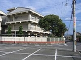
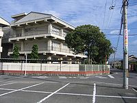 The following were kindergarten, elementary, and junior high schools in the town. There were no high schools or secondary schools in Mino.
Shikoku 88 Temple Pilgrimage
Towns of Japan
A town is a local administrative unit in Japan. It is a local public body along with prefecture , city , and village...
located in the former Mitoyo District
Mitoyo District, Kagawa
was a district located in Kagawa, Japan. On January 1, 2006 all seven towns in the district merged forming the city of Mitoyo at which point the district was dissolved....
, Kagawa
Kagawa Prefecture
is a prefecture of Japan located on Shikoku island. The capital is Takamatsu.- History :Kagawa was formerly known as Sanuki Province.For a brief period between August 1876 and December 1888, Kagawa was made a part of Ehime Prefecture.-Battle of Yashima:...
, Japan
Japan
Japan is an island nation in East Asia. Located in the Pacific Ocean, it lies to the east of the Sea of Japan, China, North Korea, South Korea and Russia, stretching from the Sea of Okhotsk in the north to the East China Sea and Taiwan in the south...
.
On January 1, 2006 Mino was merged with the towns of Nio
Nio, Kagawa
Nio was a town located in Mitoyo District, Kagawa, Japan.On January 1, 2006 Nio was merged with the towns of Mino, Saita, Takase, Takuma, Toyonaka and Yamamoto, all from Mitoyo District, to form the new city of Mitoyo and no longer exists as an independent municipality.As of 2003, the town had an...
, Saita
Saita, Kagawa
was a town located in Mitoyo District, Kagawa, Japan.On January 1, 2006 Saita was merged with the towns of Mino, Nio, Takase, Takuma, Toyonaka and Yamamoto, all from Mitoyo District, to form the new city of Mitoyo and no longer exists as an independent municipality., the town had an estimated...
, Takase
Takase, Kagawa
Takase was a town located in the former Mitoyo District, Kagawa, Japan.On January 1, 2006, Takase was merged with the towns of Mino, Nio, Saita, Takuma, Toyonaka and Yamamoto, all from Mitoyo District, to form the new city of Mitoyo and no longer exists as an independent municipality.As of 2003,...
, Takuma
Takuma, Kagawa
Takuma was a town located in the former Mitoyo District, Kagawa, Japan.On January 1, 2006 Takuma was merged with the towns of Mino, Nio, Saita, Takase, Toyonaka and Yamamoto, all from Mitoyo District, to form the new city of Mitoyo and no longer exists as an independent municipality.As of 2003,...
, Toyonaka
Toyonaka, Kagawa
Toyonaka was a town located in the former Mitoyo District, Kagawa, Japan.On January 1, 2006 Toyonaka was merged with the towns of Mino, Nio, Saita, Takase, Takuma and Yamamoto, all from Mitoyo District, to form the new city of Mitoyo and no longer exists as an independent municipality.As of 2003,...
and Yamamoto
Yamamoto, Kagawa
Yamamoto was a town located in the former Mitoyo District, Kagawa, Japan.On January 1, 2006 Mito was merged with the towns of Mino, Nio, Saita, Takase, Takuma and Toyonaka, all from Mitoyo District, to form the new city of Mitoyo and no longer exists as an independent municipality.As of 2003, the...
, all from Mitoyo District
Mitoyo District, Kagawa
was a district located in Kagawa, Japan. On January 1, 2006 all seven towns in the district merged forming the city of Mitoyo at which point the district was dissolved....
, to form the new city of Mitoyo
Mitoyo, Kagawa
is a city located in Kagawa, Japan.As of 2005, the city has an estimated population of 71,178 and a density of 320 persons per km². The total area is 222.66 km²....
and no longer exists as an independent municipality
Municipalities of Japan
Japan has three levels of government: national, prefectural, and municipal. The nation is divided into 47 prefectures. Each prefecture consists of numerous municipalities. There are four types of municipalities in Japan: cities, towns, villages and special wards...
.
As of 2005, the town had an estimated population
Population
A population is all the organisms that both belong to the same group or species and live in the same geographical area. The area that is used to define a sexual population is such that inter-breeding is possible between any pair within the area and more probable than cross-breeding with individuals...
of 9,952 and a density
Population density
Population density is a measurement of population per unit area or unit volume. It is frequently applied to living organisms, and particularly to humans...
of 501.76 persons per km². The total area was 19.34 km².
Mino had a sister city relationship with Evansville (Indiana
Indiana
Indiana is a US state, admitted to the United States as the 19th on December 11, 1816. It is located in the Midwestern United States and Great Lakes Region. With 6,483,802 residents, the state is ranked 15th in population and 16th in population density. Indiana is ranked 38th in land area and is...
), Unadilla
Unadilla
Unadilla may refer to:* Unadilla, California, a former settlement in Kern County* Unadilla, Georgia, a city in Dooly County* Unadilla, Nebraska, a village in Otoe County* Unadilla , New York, a town in Otsego County...
(New York
New York
New York is a state in the Northeastern region of the United States. It is the nation's third most populous state. New York is bordered by New Jersey and Pennsylvania to the south, and by Connecticut, Massachusetts and Vermont to the east...
State), Sanyuan County in the city of Xianyang (Shaanxi China) and Florenville
Florenville
Florenville is a Walloon municipality located in the Belgian province of Luxembourg. On 1 January 2007 the municipality had 5,448 inhabitants. The total area is 146.91 km², giving a population density of 37.1 inhabitants per km²....
(Belgium
Belgium
Belgium , officially the Kingdom of Belgium, is a federal state in Western Europe. It is a founding member of the European Union and hosts the EU's headquarters, and those of several other major international organisations such as NATO.Belgium is also a member of, or affiliated to, many...
).
The city of Mitoyo gets its name from the Mitoyo district which originally got half of its name from an older district called the Mino district, and the other half from Toyota District
Toyota District (Sanuki Province)
is a former district located in the former Sanuki Province , Japan. Former names for Toyota include and . From the Meiji period onward, it was part of Kagawa Prefecture. Toyota District was dissolved by being incorporated into the neighboring Mitoyo District....
(豊田郡).
History
- March 16, 1899 Mino DistrictMino District (Sanuki Province)is a former district located in the former Sanuki Province , Japan. On March 16, 1899, the district was dissolved by incorporating parts of it into the neighboring Toyota and Mitoyo Districts....
is dissolved by incorporating parts of it into the neighboring ToyotaToyota District (Sanuki Province)is a former district located in the former Sanuki Province , Japan. Former names for Toyota include and . From the Meiji period onward, it was part of Kagawa Prefecture. Toyota District was dissolved by being incorporated into the neighboring Mitoyo District....
and Mitoyo DistrictsMitoyo District, Kagawawas a district located in Kagawa, Japan. On January 1, 2006 all seven towns in the district merged forming the city of Mitoyo at which point the district was dissolved....
. - April 1, 1955 Shimotakase Village, Omi Village,and Yoshizu Village combine to become Mino Village.
- September 1, 1961 Renamed Mino Town.
- January 1, 2006 Combines with 6 other towns to become Mitoyo city.
Education
- Shimotakase Kindergarten
- Yoshizu Kindergarten
- Omi Kindergarten
- Shimotakase Elementary School
- Yoshizu Elementary School
- Omi Elementary School
- Minotsu Junior High School
Transportation
- Shikoku Railway CompanyShikoku Railway Company, commonly known as , is one of the constituent companies of Japan Railways Group . It operates intercity rail services in the four prefectures on the island of Shikoku in Japan. The company is headquartered in Takamatsu, Kagawa Prefecture.- Lines :...
(JR Shikoku)- Yosan LineYosan LineThe is a railway line on the island of Shikoku in Japan, operated by the Shikoku Railway Company . It runs along the Inland Sea coast, connecting the prefectural capitals of Takamatsu and Matsuyama , continuing on to Uwajima...
- Mino Station
- Tsushima no Miya Station - This station is only open for two days a year during the summer. August 4 and August 5 from 8:00 AM to 3:30 PM. It was built in 1916. The train schedule for this station is available from June to August only.
- Yosan Line
- Highways
- Expressway
- Takamatsu ExpresswayTakamatsu ExpresswayThe is an expressway running in the northeastern part of the island of Shikoku and entirely in the Kagawa Prefecture. It passes through the municipalities of Higashikagawa, Sanuki, Takamatsu, Sakaide, Marugame, Zentsuji, Mitoyo, and Kan'onji....
- There is an on/off ramp in Mino, but only heading towards Takamatsu for the on-ramp and towards Matsuyama for the off-ramp.
- Takamatsu Expressway
- National Highways
- Route 11Route 11 (Japan)National Route 11 is a Japanese highway on the island of Shikoku. The most important artery in Shikoku, it originates at the intersection with Routes 28, 55 and 195 in the prefectural capital of Tokushima and terminates at the intersection with Routes 33, 56, 317, 379, 440 and 494 in Matsuyama...
- Route 11
- Regional Highways
- Route 21 - Marugame to TakumaTakuma, KagawaTakuma was a town located in the former Mitoyo District, Kagawa, Japan.On January 1, 2006 Takuma was merged with the towns of Mino, Nio, Saita, Takase, Toyonaka and Yamamoto, all from Mitoyo District, to form the new city of Mitoyo and no longer exists as an independent municipality.As of 2003,...
to Kan'onjiKan'onji, Kagawais a city located in Kagawa, Japan.As of May 1, 2011, the city has an estimated population of 63,721, with households 23,480 and a density of 542.44 persons per km². The total area is 117.45 km².... - Route 23 - TakumaTakuma, KagawaTakuma was a town located in the former Mitoyo District, Kagawa, Japan.On January 1, 2006 Takuma was merged with the towns of Mino, Nio, Saita, Takase, Toyonaka and Yamamoto, all from Mitoyo District, to form the new city of Mitoyo and no longer exists as an independent municipality.As of 2003,...
to KotohiraKotohira, Kagawais a town located in Nakatado District, Kagawa, Japan. The town is best known as the site of Shikoku's largest shrine complex, the Kotohira Shrine .... - Route 48 - ZentsujiZentsūjiis the name of famous Buddhist temple and city in Japan. Below is an incomplete list:*Temple - Zentsū-ji. It is an origin of the following city name.*City - Zentsūji, Kagawa...
to TakumaTakuma, KagawaTakuma was a town located in the former Mitoyo District, Kagawa, Japan.On January 1, 2006 Takuma was merged with the towns of Mino, Nio, Saita, Takase, Toyonaka and Yamamoto, all from Mitoyo District, to form the new city of Mitoyo and no longer exists as an independent municipality.As of 2003,...
- Route 21 - Marugame to Takuma
- Local Routes
- Route 220 Omi to Yoshizu to NioNio, KagawaNio was a town located in Mitoyo District, Kagawa, Japan.On January 1, 2006 Nio was merged with the towns of Mino, Saita, Takase, Takuma, Toyonaka and Yamamoto, all from Mitoyo District, to form the new city of Mitoyo and no longer exists as an independent municipality.As of 2003, the town had an...
- Route 221 Miyao to TakaseTakase, KagawaTakase was a town located in the former Mitoyo District, Kagawa, Japan.On January 1, 2006, Takase was merged with the towns of Mino, Nio, Saita, Takuma, Toyonaka and Yamamoto, all from Mitoyo District, to form the new city of Mitoyo and no longer exists as an independent municipality.As of 2003,...
- Route 222 Shimotakase to TakaseTakase, KagawaTakase was a town located in the former Mitoyo District, Kagawa, Japan.On January 1, 2006, Takase was merged with the towns of Mino, Nio, Saita, Takuma, Toyonaka and Yamamoto, all from Mitoyo District, to form the new city of Mitoyo and no longer exists as an independent municipality.As of 2003,...
- Route 220 Omi to Yoshizu to Nio
- Expressway
Famous Places and Events
- Fureai Park Mino
- Tsushima ShrineTsushima Shrineis a Shinto shrine in Tsushima, Aichi Prefecture, Japan. Nationally famous, it heads the Tsushima shrine network, dedicated to the so-called . This Tōkai-centered network with its about 3000 member shrines is the tenth largest in the country. The main kami of this faith are , the god of...
- Summer Festival - Koueizan Honmonji Temple(Daibou)
- Daibouichi - End of November Exhibition
Shikoku 88 Temple PilgrimageShikoku PilgrimageThe or is a multi-site pilgrimage of 88 temples associated with the Buddhist monk Kūkai on the island of Shikoku, Japan. A popular and distinctive feature of the island's cultural landscape, and with a long history, large numbers of pilgrims still undertake the journey for a variety of ascetic,...
- Number 71 Iyadani Temple 34°13′47.8"N 133°43′28.2"E