

Miners Falls
Encyclopedia
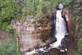
Miners Falls is a waterfall located on Miners River
in the western portion of the Pictured Rocks National Lakeshore
in Alger County, Michigan
. The falls drops about 40 feet (12.2 m) over a sandstone
outcrop with a 10 feet (3 m) crest. The falls can be accessed by trail, with stairs leading to a lookout.
Miners River
The Miners River is a river in the Upper Peninsula of Michigan. It is the largest river in the Pictured Rocks National Lakeshore. Miners River has its origin outside of the National Lakeshore, near Ginpole Lake in the Hiawatha National Forest, and flows for over 8 miles into Lake Superior. Miners...
in the western portion of the Pictured Rocks National Lakeshore
Pictured Rocks National Lakeshore
Pictured Rocks National Lakeshore is a U.S. National Lakeshore on the shore of Lake Superior in the Upper Peninsula of Michigan, United States. It extends for 42 miles along the shore and covers...
in Alger County, Michigan
Alger County, Michigan
Alger County is a county in the U.S. state of Michigan. As of the 2010 census, the population was 9,601. Its county seat is Munising. The Pictured Rocks National Lakeshore is located within the county.-History:...
. The falls drops about 40 feet (12.2 m) over a sandstone
Sandstone
Sandstone is a sedimentary rock composed mainly of sand-sized minerals or rock grains.Most sandstone is composed of quartz and/or feldspar because these are the most common minerals in the Earth's crust. Like sand, sandstone may be any colour, but the most common colours are tan, brown, yellow,...
outcrop with a 10 feet (3 m) crest. The falls can be accessed by trail, with stairs leading to a lookout.