
Mimoso de Goiás
Encyclopedia
| Mimoso de Goiás | |
|---|---|
| State | Goiás Goiás Goiás is a state of Brazil, located in the central part of the country. The name Goiás comes from the name of an indigenous community... |
| Coordinates: | 15°03′53"S 48°09′30"W |
| Area: | 1,386.9 km² |
| Population: | 2,836 (IBGE 2007) |
| Urban and Rural Population: | 1,249 / 1,587 |
| Population density: | 2.04 inhab/km² (2007) |
| Elevation: | 675 m above sea level |
| Postcode (CEP): | 73730-000 |
| IBGE statistical microregion: | Entorno de Brasília |
| Became a city: | 1987 |
| Mayor: | Antônio da Costa Tavares |
| Distance to Goiânia Goiânia -Climate:The city has a tropical wet and dry climate with an average temperature of . There's a wet season, from October to April, and a dry one, from May to September. Annual rainfall is around 1,520 mm.... : |
304 km. |
| Website: | none |

Town
A town is a human settlement larger than a village but smaller than a city. The size a settlement must be in order to be called a "town" varies considerably in different parts of the world, so that, for example, many American "small towns" seem to British people to be no more than villages, while...
and municipality
Municipality
A municipality is essentially an urban administrative division having corporate status and usually powers of self-government. It can also be used to mean the governing body of a municipality. A municipality is a general-purpose administrative subdivision, as opposed to a special-purpose district...
in northeastern Goiás
Goiás
Goiás is a state of Brazil, located in the central part of the country. The name Goiás comes from the name of an indigenous community...
state, Brazil
Brazil
Brazil , officially the Federative Republic of Brazil , is the largest country in South America. It is the world's fifth largest country, both by geographical area and by population with over 192 million people...
.
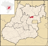
Mimoso is located in statistical microregion 012, called Entorno de Brasília. It is almost directly north of Brasília
Brasília
Brasília is the capital city of Brazil. The name is commonly spelled Brasilia in English. The city and its District are located in the Central-West region of the country, along a plateau known as Planalto Central. It has a population of about 2,557,000 as of the 2008 IBGE estimate, making it the...
and is on an unpaved highway linking Padre Bernardo
Padre Bernardo
Padre Bernardo is a small city and municipality north of the Federal District of Brazil in Goiás state, Brazil.-Location:Padre Bernardo is located 42 km. north of the boundary with the Federal District...
to Água Fria de Goiás
Água Fria de Goiás
Água Fria de Goiás is a small town and municipality in northern Goiás state, Brazil.-Location:Água Fria became a city in 1989 when it was dismembered from Planaltina de Goiás in 1989. Água Fria is located in the microregion called Entorno de Brasília, although it is almost 156 kilometers to the...
. Municipal boundaries are with:
- north: NiquelândiaNiquelândiaNiquelândia is a small city and municipality in northern Goiás state, Brazil. It is the largest municipality in the state in area and is an important producer of minerals.-Geography:...
- west: Vila PropícioVila PropícioVila Propício is a small town and municipality in central Goiás state, Brazil. It is a large producer of sugarcane.-Location:Vila Propício is located in the Entorno de Brasília micro-region and has boundaries with the following municipalities:...
and Planaltina de GoiásPlanaltina de GoiásPlanaltina is a city located in the center of the state of Goiás, Brazil. Planaltina is often referred to as Planaltina de Goiás, but in official documents it is called Planaltina.-Location and Geography:... - east: Água Fria de GoiásÁgua Fria de GoiásÁgua Fria de Goiás is a small town and municipality in northern Goiás state, Brazil.-Location:Água Fria became a city in 1989 when it was dismembered from Planaltina de Goiás in 1989. Água Fria is located in the microregion called Entorno de Brasília, although it is almost 156 kilometers to the...
- south: Padre BernardoPadre BernardoPadre Bernardo is a small city and municipality north of the Federal District of Brazil in Goiás state, Brazil.-Location:Padre Bernardo is located 42 km. north of the boundary with the Federal District...
The economy is based on cattle raising , services consisting of shops selling the basic necessities, government employment, and subsistence farming. There are some larger plantations of soybeans, corn, and beans.
In 2006 there were 55,000 head of cows, with most of them being for meat production. The main agricultural products in planted area were cotton, rice, sugarcane, beans, manioc, corn, and soybeans (3,700 hectares). Only the last had a planted area exceeding 500 hectares. A recent agricultural product is the pupunha (Bactris Gasipaes Kunth), a type of palm from which is extracted oil and flour. Also see Palmitoseloverde
The ranking on the 2000 Human Development Index
Human Development Index
The Human Development Index is a composite statistic used to rank countries by level of "human development" and separate "very high human development", "high human development", "medium human development", and "low human development" countries...
was 0.664
- State ranking: 229 (out of 242 municipalities in 2000)
- National ranking: 3,548 (out of 5,507 municipalities in 2000)
- Schools: 11 with 1,070 students (2006)
- Hospitals: none (2007)
- Literacy rate: 75.3% (2000)
- Infant mortality rate: 27.83 (2000)
Mimoso was created as a district of Niquelândia
Niquelândia
Niquelândia is a small city and municipality in northern Goiás state, Brazil. It is the largest municipality in the state in area and is an important producer of minerals.-Geography:...
in 1951. In 1975 it was transferred to the municipality of Padre Bernardo
Padre Bernardo
Padre Bernardo is a small city and municipality north of the Federal District of Brazil in Goiás state, Brazil.-Location:Padre Bernardo is located 42 km. north of the boundary with the Federal District...
. In 1987 it was dismembered from Padre Bernardo and elevated to a municipality, which was installed in 1989.
Sources of Data
See also
- List of municipalities in Goiás
- Microregions of Goiás