

Milltir Cerrig
Encyclopedia
Mountain pass
A mountain pass is a route through a mountain range or over a ridge. If following the lowest possible route, a pass is locally the highest point on that route...
in Wales
Wales
Wales is a country that is part of the United Kingdom and the island of Great Britain, bordered by England to its east and the Atlantic Ocean and Irish Sea to its west. It has a population of three million, and a total area of 20,779 km²...
, on the B4391 between Bala
Bala, Gwynedd
Bala is a market town and community in Gwynedd, Wales, and formerly an urban district of the historic county of Merionethshire. It lies at the north end of Bala Lake , 17 miles north-east of Dolgellau, with a population of 1,980...
(in the county of Gwynedd
Gwynedd
Gwynedd is a county in north-west Wales, named after the old Kingdom of Gwynedd. Although the second biggest in terms of geographical area, it is also one of the most sparsely populated...
) and Llangynog
Llangynog
Llangynog lies at the confluence of the Afon Eirth and the Afon Tanat at the foot of the Berwyn range in Powys, Wales. Pop c.300It lies at the foot of the Milltir Cerrig mountain pass on the B4391 road, which runs between Llan Ffestiniog and Llanfyllin .It is surrounded by mountains and is a...
(Powys
Powys
Powys is a local-government county and preserved county in Wales.-Geography:Powys covers the historic counties of Montgomeryshire and Radnorshire, most of Brecknockshire , and a small part of Denbighshire — an area of 5,179 km², making it the largest county in Wales by land area.It is...
), briefly passing through Denbighshire
Denbighshire
Denbighshire is a county in north-east Wales. It is named after the historic county of Denbighshire, but has substantially different borders. Denbighshire has the distinction of being the oldest inhabited part of Wales. Pontnewydd Palaeolithic site has remains of Neanderthals from 225,000 years...
.
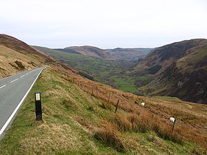
It crosses the Berwyn mountain range
Berwyn range
The Berwyn range is an isolated and sparsely populated area of moorland located in the north-east of Wales, roughly bounded by Llangollen in the north-east, Corwen in the north-west, Bala in the south-west, and Oswestry in the south-east.The Berwyn range also played its part in causing King Henry...
at an altitude of 486 metres (1594 feet). From the summit of the pass, a bridleway heads east across the main Berwyn summits; Moel Sych
Moel Sych
Moel Sych is a subsidiary summit of Cadair Berwyn in north east Wales. It is jointly the second highest summit in the Berwyn range along with Cadair Berwyn North Top....
, Cadair Berwyn
Cadair Berwyn
Cadair Berwyn or Cader Berwyn is a mountain summit in north east Wales. It is the highest point in the Berwyn range, and the highest significant summit in Wales outside the National Parks. Cadair Berwyn and Cyrniau Nod to the west are the two Marilyns that form the Berwyn range.The mountain lies on...
and Cadair Bronwen
Cadair Bronwen
Cadair Bronwen is a mountain in North Wales and forms part of the Berwyn range. To the south are the higher Berwyn summits, including Cadair Berwyn. To the north lies Moel yr Henfaes and Moel Fferna, which top the north end of the Berwyn range. Cadair Bronwen used to be accompanied by a Nuttall...
. These three peaks can be seen on the climb from Bala.
The mountain pass is approximately 9 miles long; a 4-mile climb up the head of the Tanat Valley from Llangynog, or 5 miles across bleak moorland
Moorland
Moorland or moor is a type of habitat, in the temperate grasslands, savannas, and shrublands biome, found in upland areas, characterised by low-growing vegetation on acidic soils and heavy fog...
from the B4391/B4402 junction near Bala.