
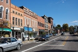
Millersburg, Ohio
Encyclopedia
Millersburg is a village in Holmes County
, Ohio
, in the United States
. As of the 2000 census
, the village population was 3,326. It is the county seat
of Holmes County
.
. Millersburg is located 817 feet (249 m) above sea level.
According to the United States Census Bureau
, the village has a total area of 2.0 square miles (5.2 km²), all of it land.
of 2000, there were 3,326 people, 1,213 households, and 771 families residing in the village. The population density
was 1,649.0 people per square mile (635.7/km²). There were 1,360 housing units at an average density of 674.3 per square mile (260.0/km²). The racial makeup of the village was 96.87% White, 1.47% African American, 0.09% Asian, 0.03% Pacific Islander, 0.54% from other races
, and 0.99% from two or more races. Hispanic or Latino of any race were 2.01% of the population.
There were 1,213 households out of which 32.6% had children under the age of 18 living with them, 47.1% were married couples
living together, 12.5% had a female householder with no husband present, and 36.4% were non-families. 30.8% of all households were made up of individuals and 13.1% had someone living alone who was 65 years of age or older. The average household size was 2.43 and the average family size was 3.05.
In the village the population was spread out with 24.8% under the age of 18, 9.6% from 18 to 24, 26.9% from 25 to 44, 20.0% from 45 to 64, and 18.8% who were 65 years of age or older. The median age was 37 years. For every 100 females there were 93.8 males. For every 100 females age 18 and over, there were 90.8 males.
The median income for a household in the village was $33,809, and the median income for a family was $39,333. Males had a median income of $26,852 versus $20,472 for females. The per capita income
for the village was $15,021. About 9.6% of families and 12.2% of the population were below the poverty line, including 17.9% of those under age 18 and 4.1% of those age 65 or over.
The direction of High and Market Streets were north and south. High was located on the State Road from Coshocton to Wooster. This road was a little to the east of the Maxwell (Balk Eagle) Mills, and up the steep bank near, but east of T. J. Cary's cottage house; and a little to the east of the old one and a half story frame buillding, commonly known as the Witheros and Teisher house. Market Street was parallel with High, and located 32 rods to the east of it. After the settlement of the town most of the travel from the south went up Market Street. There were other streets and alleys, but I trust those mentioned will give the reader a correct idea of the location and size of the OLD Town. The proprietors did not sell any lots in the Old Town until the beginning of 1819, and then deed swere not executed, the purchasers holding under a title-bond.In April 1821. the question of the new county and the moving of the town to the south side of Section 12 was the topic. These obstacles were great "draw-backs" to the settlement of Old Town.
Thomas Haskins was the first settler on the town plat, settling there in the Spring of 1819, on lot21, corner of Bridge and High Streets. In the Spring of 1820. James Withrow erected a one-and-a-half story building on Lot 33 cornering on Bridge and High Streets and diagonally across them from the Haskins tavern,
In late 1820 a cabin was erected in the northeast corner of the town for a school house. Joseph Edger of Berlin, taught at the school that winter, and it was the first school in the town. During that winter the Rev. Harper, a Presbyterian minister, preached in the School House which was the first sermon delivered in Millersburg. On April 8, 1824, Andrew Johnston and Charles Miller filed a plan for the present town of Millersburg. "New Town" as it was referred to, was situated south east of the original town of Millersburg (Old Town), The new plan laid out 194 lots. The center of this plan consisted of a block for public use. The main East - West Street was named Jackson. To the North of this was Clinton and to the South, Adams. The North-South streets were Mad Anthony, Washington, Clay, Monroe and Crawford with the main intersection being Clay and Jackson. The first two residences in the town were build by James French and William Painter. When Millersburg was accepted as the county seat of the newly formed Holmes County it began to prosper.
Holmes County, Ohio
As of the census of 2000, there were 38,943 people, 11,337 households, and 9,194 families residing in the county. The population density was 92 people per square mile . There were 12,280 housing units at an average density of 29 per square mile...
, Ohio
Ohio
Ohio is a Midwestern state in the United States. The 34th largest state by area in the U.S.,it is the 7th‑most populous with over 11.5 million residents, containing several major American cities and seven metropolitan areas with populations of 500,000 or more.The state's capital is Columbus...
, in the United States
United States
The United States of America is a federal constitutional republic comprising fifty states and a federal district...
. As of the 2000 census
United States Census, 2000
The Twenty-second United States Census, known as Census 2000 and conducted by the Census Bureau, determined the resident population of the United States on April 1, 2000, to be 281,421,906, an increase of 13.2% over the 248,709,873 persons enumerated during the 1990 Census...
, the village population was 3,326. It is the county seat
County seat
A county seat is an administrative center, or seat of government, for a county or civil parish. The term is primarily used in the United States....
of Holmes County
Holmes County, Ohio
As of the census of 2000, there were 38,943 people, 11,337 households, and 9,194 families residing in the county. The population density was 92 people per square mile . There were 12,280 housing units at an average density of 29 per square mile...
.
Geography
Millersburg is located at 40°33′18"N 81°55′5"W (40.554901, -81.917940), along Killbuck CreekKillbuck Creek
Killbuck Creek is a tributary of the Walhonding River, 81.7 mi long, in north-central Ohio in the United States. Via the Walhonding, Muskingum and Ohio Rivers, it is part of the watershed of the Mississippi River...
. Millersburg is located 817 feet (249 m) above sea level.
According to the United States Census Bureau
United States Census Bureau
The United States Census Bureau is the government agency that is responsible for the United States Census. It also gathers other national demographic and economic data...
, the village has a total area of 2.0 square miles (5.2 km²), all of it land.
Demographics
As of the censusCensus
A census is the procedure of systematically acquiring and recording information about the members of a given population. It is a regularly occurring and official count of a particular population. The term is used mostly in connection with national population and housing censuses; other common...
of 2000, there were 3,326 people, 1,213 households, and 771 families residing in the village. The population density
Population density
Population density is a measurement of population per unit area or unit volume. It is frequently applied to living organisms, and particularly to humans...
was 1,649.0 people per square mile (635.7/km²). There were 1,360 housing units at an average density of 674.3 per square mile (260.0/km²). The racial makeup of the village was 96.87% White, 1.47% African American, 0.09% Asian, 0.03% Pacific Islander, 0.54% from other races
Race (United States Census)
Race and ethnicity in the United States Census, as defined by the Federal Office of Management and Budget and the United States Census Bureau, are self-identification data items in which residents choose the race or races with which they most closely identify, and indicate whether or not they are...
, and 0.99% from two or more races. Hispanic or Latino of any race were 2.01% of the population.
There were 1,213 households out of which 32.6% had children under the age of 18 living with them, 47.1% were married couples
Marriage
Marriage is a social union or legal contract between people that creates kinship. It is an institution in which interpersonal relationships, usually intimate and sexual, are acknowledged in a variety of ways, depending on the culture or subculture in which it is found...
living together, 12.5% had a female householder with no husband present, and 36.4% were non-families. 30.8% of all households were made up of individuals and 13.1% had someone living alone who was 65 years of age or older. The average household size was 2.43 and the average family size was 3.05.
In the village the population was spread out with 24.8% under the age of 18, 9.6% from 18 to 24, 26.9% from 25 to 44, 20.0% from 45 to 64, and 18.8% who were 65 years of age or older. The median age was 37 years. For every 100 females there were 93.8 males. For every 100 females age 18 and over, there were 90.8 males.
The median income for a household in the village was $33,809, and the median income for a family was $39,333. Males had a median income of $26,852 versus $20,472 for females. The per capita income
Per capita income
Per capita income or income per person is a measure of mean income within an economic aggregate, such as a country or city. It is calculated by taking a measure of all sources of income in the aggregate and dividing it by the total population...
for the village was $15,021. About 9.6% of families and 12.2% of the population were below the poverty line, including 17.9% of those under age 18 and 4.1% of those age 65 or over.
History
The Old Town of Millersburg was laid out by Adam Johnson and Charles Miller of Coshocton County, Ohio, in November 1815. It was located at the north side of the northwest quarter of Section 12, township 9, range 7 adjoining the School Lands, and very near the northwest corner of said quarter section. The Northwest corner, lot 1, was a little over the hill towards the present mill dam and the northeast corner, lot 9, was about 100 steps west of the present Wooster Road. The center of the town was very nearly the center of Walkups Addition. The principal streets were Bridge, High and Market, each 4 rods wide. The direction of the former was east and west, and ll rods south of the School land; and was located on the State Road east and west through the county, that crosses the Killbuck near the present mill dam.The direction of High and Market Streets were north and south. High was located on the State Road from Coshocton to Wooster. This road was a little to the east of the Maxwell (Balk Eagle) Mills, and up the steep bank near, but east of T. J. Cary's cottage house; and a little to the east of the old one and a half story frame buillding, commonly known as the Witheros and Teisher house. Market Street was parallel with High, and located 32 rods to the east of it. After the settlement of the town most of the travel from the south went up Market Street. There were other streets and alleys, but I trust those mentioned will give the reader a correct idea of the location and size of the OLD Town. The proprietors did not sell any lots in the Old Town until the beginning of 1819, and then deed swere not executed, the purchasers holding under a title-bond.In April 1821. the question of the new county and the moving of the town to the south side of Section 12 was the topic. These obstacles were great "draw-backs" to the settlement of Old Town.
Thomas Haskins was the first settler on the town plat, settling there in the Spring of 1819, on lot21, corner of Bridge and High Streets. In the Spring of 1820. James Withrow erected a one-and-a-half story building on Lot 33 cornering on Bridge and High Streets and diagonally across them from the Haskins tavern,
In late 1820 a cabin was erected in the northeast corner of the town for a school house. Joseph Edger of Berlin, taught at the school that winter, and it was the first school in the town. During that winter the Rev. Harper, a Presbyterian minister, preached in the School House which was the first sermon delivered in Millersburg. On April 8, 1824, Andrew Johnston and Charles Miller filed a plan for the present town of Millersburg. "New Town" as it was referred to, was situated south east of the original town of Millersburg (Old Town), The new plan laid out 194 lots. The center of this plan consisted of a block for public use. The main East - West Street was named Jackson. To the North of this was Clinton and to the South, Adams. The North-South streets were Mad Anthony, Washington, Clay, Monroe and Crawford with the main intersection being Clay and Jackson. The first two residences in the town were build by James French and William Painter. When Millersburg was accepted as the county seat of the newly formed Holmes County it began to prosper.