
.gif)
Military Park (NCS station)
Encyclopedia
Newark Light Rail
The Newark Light Rail is a light rail system under New Jersey Transit Bus Operations serving Newark, New Jersey. The service consists of two segments, the original Newark City Subway, and the extension to Broad Street station...
. The station is owned and service is operated by New Jersey Transit
New Jersey Transit
The New Jersey Transit Corporation is a statewide public transportation system serving the United States state of New Jersey, and New York, Orange, and Rockland counties in New York State...
. The station is located at the intersection of Raymond Boulevard
Raymond Boulevard
Raymond Boulevard is a major thoroughfare in Newark, New Jersey. The eastern portion of the road acts as the westbound member of a one-way pair; eastbound traffic uses Market Street and Ferry Street...
, Park Place and Broad Street in Downtown Newark
Downtown Newark
Downtown Newark is Newark, New Jersey's major central business, retail, and cultural district. It is located at a bend in the Passaic River.Downtown is the site of the original Puritan settlement of Newark. The first settlers, led by Robert Treat, landed not far from the present site of the New...
at Military Park
Military Park (Newark)
Military Park is a city park in downtown Newark, New Jersey. It is a nearly triangular park located between Park Place, Rector Street and Broad Street. From 1667, when the city was planned, until 1869 it was a training ground for soldiers...
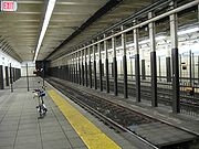
. The station was opened in 1935 and called Broad Street Station. It was renamed so only one station in the system would carry the name Broad Street when Downtown Newark's stations (Penn Station and Broad Street) were connected by the Newark Light Rail Line. The station is decorated with beige tiles and colored tiles for borders, mosaics and street indicator signs. This station is not wheelchair accessible. The adjacent stations, Penn Station
Pennsylvania Station (Newark)
Pennsylvania Station is a major transportation hub in Newark, New Jersey. Located at Raymond Plaza, between Market Street and Raymond Boulevard, Newark Penn Station is served by the Newark Light Rail, New Jersey Transit commuter rail, Amtrak long distance trains, the PATH rapid transit system, and...
and Washington St.
Washington Street (NCS station)
Washington Street Station is an underground station on the Newark City Subway Line of the Newark Light Rail system. The station is owned and service is operated by New Jersey Transit. The station is located at the intersection of Raymond Boulevard and Washington Street with a second entrance at...
are handicap accessible.
History
In 1910, the Public Service Corporation planned to build two subway lines meeting at Broad Street (now Military Park). An additional north-south line would have connected Bridge Street to the north with Clinton Avenue near The Coast/Lincoln ParkThe Coast, Newark, New Jersey
The Coast or Lincoln Park is a neighborhood of Newark, New Jersey, bounded by the Springfield/Belmont, South Broad Valley, South Ironbound and Downtown neighborhoods. It is bounded by Martin Luther King Jr. Blvd. to the west, Kinney St. to the north, the McCarter Highway to the east and South...
neighborhood near Lincoln Park. The proposed second segment of the Newark-Elizabeth Rail Link
Newark-Elizabeth Rail Link
The Newark-Elizabeth Rail Link was a proposed -long light rail line in New Jersey, USA, which would have connected the downtown areas of Newark and Elizabeth with the Newark Liberty International Airport and been operated by New Jersey Transit...
(NERL) together with the first segment, the Newark Light Rail would service this area. The existing Newark City Subway Line was built in the old Morris Canal
Morris Canal
The Morris Canal was an anthracite-carrying canal that incorporated a series of water-driven inclined planes in its course across northern New Jersey in the United States. It was in use for about a century — from the late 1820s to the 1920s....
bed with construction beginning in 1929 and service starting on the line on May 26, 1935.
Attractions
- Military ParkMilitary Park (Newark)Military Park is a city park in downtown Newark, New Jersey. It is a nearly triangular park located between Park Place, Rector Street and Broad Street. From 1667, when the city was planned, until 1869 it was a training ground for soldiers...
- New Jersey Historical SocietyNew Jersey Historical SocietyThe New Jersey Historical Society is a historical society and museum located in Newark, New Jersey, United States. The Historical Society is housed in the former headquarters of the Essex Club. It has two floors of exhibition space, a gift shop, and a hall for lectures. The NJHS offers occasional...
- Aljira Gallery
- Park Place Farmers Market
- Trinity and St. Phillips Cathedral
- East Coast GreenwayEast Coast GreenwayThe East Coast Greenway, or ECG, is a project to create a nearly urban path linking the major cities of the Atlantic coast of the United States, from Calais, Maine, to Key West, Florida, for non-motorized human transportation...
(undeveloped) - Lenape TrailLenape TrailThe Lenape Trail is a trail connecting Newark, New Jersey with Roseland, New Jersey. It was established in 1982. It is the fifth longest trail in the state behind the Delaware and Raritan Canal Trail, the Appalachian Trail, the completed section of the Highlands Trail in the state and the Batona...
(unmarked) - shops and restaurants and hotels
Other Attractions
These attractions are less than a half mile from Military Park Station and not served by a closer station:- Prudential Center
- Government CenterGovernment Center, Newark, New JerseyGovernment Center is an area of Downtown Newark that is named for the presence of government buildings centered around a plaza known as Federal Square....
:- Newark City Hall
Transfers
Connections are available to the following lines:- NJ TransitNew Jersey Transit Bus OperationsNew Jersey Transit Bus Operations is the bus division of New Jersey Transit, providing bus service throughout New Jersey along with service along one light rail line, with many routes going to New York City and Philadelphia.-History:...
: 13, 27, 39, 40, 41, 42, 43, 59, 62, 65, 66, 67, 70, 71, 72, 73, 76, 78, 79 and 108 - ONE Bus: 24, 44