
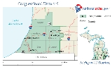
Michigan's 6th congressional district
Encyclopedia
.png)
United States
The United States of America is a federal constitutional republic comprising fifty states and a federal district...
congressional district
Congressional district
A congressional district is “a geographical division of a state from which one member of the House of Representatives is elected.”Congressional Districts are made up of three main components, a representative, constituents, and the specific land area that both the representative and the...
in southwest Michigan
Michigan
Michigan is a U.S. state located in the Great Lakes Region of the United States of America. The name Michigan is the French form of the Ojibwa word mishigamaa, meaning "large water" or "large lake"....
. It consists of all of Berrien
Berrien County, Michigan
Berrien County is a county located in the extreme southwest of the U.S. state of Michigan. It is included in the Niles-Benton Harbor, Michigan Metropolitan Statistical Area. As of the 2010 census, the population was 156,813. The county seat is St. Joseph....
, Cass
Cass County, Michigan
Cass County is a county in the U.S. state of Michigan. As of the 2000 census, the population was 51,104. It is part of the South Bend–Mishawaka, IN-MI, Metropolitan Statistical Area which has a total population of 316,663 and is sometimes considered part of Greater Michiana...
, Kalamazoo
Kalamazoo County, Michigan
-Air Service:*The Kalamazoo & Battle Creek Metro Area is served by Kalamazoo/Battle Creek International Airport.-Interstates:* I-94* I-94 Business Loop-US highways:* US-131* BUS US 131-Michigan State Trunklines:* M-43* M-89* M-96...
, St. Joseph
St. Joseph County, Michigan
-Demographics:As of the census of 2000, there were 62,422 people, 23,381 households, and 16,600 families residing in the county. The population density was 124 people per square mile . There were 26,503 housing units at an average density of 53 per square mile...
, and Van Buren
Van Buren County, Michigan
-Parks, preserves, natural areas:* Dunes Parkway, an 84 acre preserve of dunes in Covert Township* Jeptha Lake Fen Preserve, a 49 acre preserve in Columbia Township...
, counties, and includes most of southern and eastern Allegan
Allegan County, Michigan
-Interstates:* I-196* I-196 Business Loop serves the city of Holland.-US highways:* US-31* US-131-Michigan State Trunklines:* M-40* M-89* M-179* M-222-Allegan County Intercounty Highways:* A-2* A-37* A-42* A-45-Demographics:...
and a portion of western Calhoun
Calhoun County, Michigan
-Interstates:* I-69* I-94* I-194* I-94 Business Loop serves the city of Albion.* I-94 Business Loop serves the city of Battle Creek.* I-94 Business Loop serves the city of Marshall.-Michigan State Trunklines:* M-37* M-60* M-66* M-78* M-89* M-96* M-99...
counties.
Major cities
- AlleganAllegan, MichiganAllegan is a city in the U.S. state of Michigan. As of the 2000 census, the city population was 4,838. It is the county seat of Allegan County. The city lies within Allegan Township, but is administratively autonomous....
- Benton HarborBenton Harbor, MichiganBenton Harbor is a city in Berrien County in the U.S. state of Michigan which is located west of Kalamazoo. The population was 10,038 at the 2010 census. It is the lesser populated of the two principal cities included in the Niles-Benton Harbor, Michigan Metropolitan Statistical Area, which has a...
- CassopolisCassopolis, MichiganCassopolis is a village in the U.S. state of Michigan. As of the 2010 census, the village population was 14,275. It is the county seat of Cass County. The village and county are named after statesman Lewis Cass, a New Hampshire native and a prominent U.S...
- NilesNiles, MichiganNiles is a city in Berrien and Cass counties in the U.S. state of Michigan, near South Bend, Indiana. The population was 11,600 at the 2010 census. It is the greater populated of two principal cities of and included in the Niles-Benton Harbor, Michigan Metropolitan Statistical Area, which has a...
- KalamazooKalamazoo, MichiganThe area on which the modern city stands was once home to Native Americans of the Hopewell culture, who migrated into the area sometime before the first millennium. Evidence of their early residency remains in the form of a small mound in downtown's Bronson Park. The Hopewell civilization began to...
- Paw PawPaw Paw, MichiganPaw Paw is a village in the U.S. state of Michigan. As of the 2000 census, the village population was 3,363. It is the county seat of Van Buren County.-Overview:...
- PortagePortage, MichiganPortage is a city in Kalamazoo County in the U.S. state of Michigan. The population was 46,292 at the 2010 census. It is the smaller of the two main cities included in the Kalamazoo-Portage Metropolitan Statistical Area, which has a population of 326,589 as of 2010.Portage is adjacent to the...
- St. JosephSt. Joseph, MichiganSt. Joseph is a city in the US state of Michigan. It was incorporated as a village in 1834 and as a city in 1891. As of the 2000 census, the city population was 8,789. It lies on the shore of Lake Michigan, at the mouth of the St. Joseph River, about east-northeast of Chicago. It is the county...
- South HavenSouth Haven, MichiganSouth Haven is a city in the U.S. state of Michigan. Most of the city is in Van Buren County, although a small portion extends into Allegan County. The population was 5,021 at the 2000 census....
- SturgisSturgis, MichiganSturgis, is a city in St. Joseph County in the U.S. state of Michigan. The population was 10,994 at the 2010 census. The city is located at the northeast corner of Sturgis Township and at the intersection of US 12 and M-66....
- Three RiversThree Rivers, MichiganThree Rivers is a city in St. Joseph County in the US state of Michigan. The population was 7,811 at the 2010 census.Three Rivers derives its name from the confluence of the St. Joseph River with its tributaries the Rocky and Portage Rivers. It is the home of St...
History
Michigan's Sixth Congressional District was originally formed in 1862. At this time it had all the Upper Peninsula except MenomineeMenominee County, Michigan
-Demographics:As of the census of 2000, there were 25,326 people, 10,529 households, and 7,001 families residing in the county. The population density was 24 people per square mile . There were 13,639 housing units at an average density of 13 per square mile...
, Delta
Delta County, Michigan
-Demographics:As of the census of 2000, there were 38,520 people, 15,836 households, and 10,689 families residing in the county. The population density was 33 people per square mile . There were 19,223 housing units at an average density of 16 per square mile...
and Mackinac
Mackinac County, Michigan
-Local Airports:*Mackinac County Airport *Mackinac Island Airport -Airline service:The nearest airports with scheduled passenger service are:*Chippewa County International Airport in Sault Ste...
counties.
The district was vaguely contiguous, in that it did not contain the Straits of Mackinac
Straits of Mackinac
The Straits of Mackinac is the strip of water that connects two of the Great Lakes, Lake Michigan and Lake Huron, and separates the Lower Peninsula of Michigan from the Upper Peninsula of Michigan. It is a shipping lane providing passage for raw materials and finished goods, connecting, for...
but did include Presque Isle County
Presque Isle County, Michigan
Presque Isle County is a county in the U.S. state of Michigan. As of the 2000 census, the population was 14,411. The county seat is Rogers City....
, which can be reached without going through another district's area. It included another 21 counties on the Lower Peninsula. The southern boundary of the district was formed by Clinton
Clinton County, Michigan
-Demographics:As of the census of 2000, there were 64,753 people, 23,653 households, and 17,976 families residing in the county. The population density was 113 people per square mile . There were 24,630 housing units at an average density of 43 per square mile...
, Shiawassee
Shiawassee County, Michigan
-Transportation:-Demographics:As of the census of 2000, there were 71,687 people, 26,896 households, and 19,849 families residing in the county. The population density was 133 people per square mile . There were 29,087 housing units at an average density of 54 per square mile...
, Genesee
Genesee County, Michigan
-Interstates:* I-69* I-75* I-475-Michigan State Trunklines:* M-13* M-15* M-21* M-54* M-57-Demographics:As of the census of 2000, there were 436,141 people, 169,825 households, and 115,990 families residing in the county. The population density was 682 people per square mile . There were 183,630...
, Tuscola
Tuscola County, Michigan
-Highways:* M-15* M-24* M-25* M-46* M-81* M-138-Demographics:As of the census of 2000, there were 58,266 people, 21,454 households, and 15,983 families residing in the county. The population density was 72 people per square mile . There were 23,378 housing units at an average density of 29 per...
and Huron
Huron County, Michigan
-Highways:* M-19* M-25* M-53* M-142-Demographics:As of the census of 2000, there were 36,079 people, 14,597 households, and 10,144 families residing in the county. The population density was 43 people per square mile . There were 20,430 housing units at an average density of 24 per square mile...
counties. The district had a population of 97,783.
In 1872, the Sixth District was shifted southward. It retained Clinton, Shiawassee, and Genesee counties while adding Ingham
Ingham County, Michigan
-Demographics:As of the census of 2000, there were 279,320 people, 108,593 households, and 63,744 families residing in the county. The population density was 500 people per square mile . There were 115,056 housing units at an average density of 206 per square mile...
, Livingston
Livingston County, Michigan
-Demographics:As of the census of 2000, there were 156,951 people, 55,384 households, and 43,531 families residing in the county. The population density was 276 people per square mile . There were 58,919 housing units at an average density of 104 per square mile...
and Oakland
Oakland County, Michigan
-Demographics:As of the 2010 Census, there were 1,202,362 people, 471,115 households, and 315,175 families residing in the county. The population density as of the 2000 census was 1,369 people per square mile . There were 492,006 housing units at an average density of 564 per square mile...
counties. With 163,000 residents the district had 12,000 more inhabitants than the next most populous district, and 65,000 more residents than Michigan's least populous district.
In 1882, Shiawassee County was removed from the district. The new district had about 165,000 people. In 1892, Clinton County was removed but the townships of Livonia, Nankin, Redford, Greenfield, Springwells, and Dearborn in Wayne County
Wayne County, Michigan
-History:Wayne County was one of the first counties formed when the Northwest Territory was organized. It was named for the American general "Mad Anthony" Wayne. It originally encompassed the entire area of the Lower Peninsula of Michigan, as well as small sections that are now part of northern...
were added, as well as the part of Detroit west of Lawton. All of Greenfield, and parts of Springwells and Redford Townships have since been incorporated into the city of Detroit. This new district had a population of 190,539 that was 0.8% African-American.
No changes were made in the boundaries of the district in 1902. Its population had risen to 221,699.
It was not until 1932 that the boundaries of the 6th district were altered. In this year it lost its parts of Oakland and Wayne counties and was shifted to Ingham, Livingston, and Genesee Counties. These boundaries were not changed until 1964, when the district was redrawn to cover Jackson
Jackson County, Michigan
As of the census of 2000, there were 158,422 people, 58,168 households, and 40,833 families residing in the county. The population density was 224 people per square mile . There were 62,906 housing units at an average density of 89/sq mi...
, Ingham, and Shiawassee counties.
In 1972, the district was redrawn to include Jackson, Ingham, and Livingston counties, as well as the western portion of Washtenaw County
Washtenaw County, Michigan
Washtenaw County is a county in the U.S. state of Michigan. As of the 2010 census, the population was 344,791. Its county seat is Ann Arbor. The United States Office of Management and Budget defines the county as part of the Detroit–Warren–Flint Combined Statistical Area...
.
In 1982 the district was redrawn to Ingham, Livingston, and northwestern Oakland counties with a finger stretching all the way to Pontiac
Pontiac, Michigan
Pontiac is a city in the U.S. state of Michigan named after the Ottawa Chief Pontiac, located within the Detroit metropolitan area. As of the 2010 census, the city had a total population of 59,515. It is the county seat of Oakland County...
. Waterford Township was in the district, as was Auburn Hills, but Orion Township, Rochester Hills and Bloomfield Hills were all in other districts. The boundaries also included Independence Township, White Lake Township, Rose Township, Springfield Township and Highland Township. Brighton and the areas directly east of it in Livingston County were also not in this district. Most of Lansing was put in the 3rd District
Michigan's 3rd congressional district
Michigan's 3rd congressional district is a United States Congressional district in Western Michigan. It consists of the counties of Barry, Ionia, and all except the northwest portion of Kent. The district is currently represented by Republican Justin Amash, the second youngest member of the house...
. In Jackson County the district covered Henrietta Township
Henrietta Township, Michigan
Henrietta Township is a civil township of Jackson County in the U.S. state of Michigan. The population was 4,483 at the 2000 census.- History :...
, Rives Township, and Tompkins Township. In Clinton County it included Bath Township. In Shiawassee County the district included Antrim Township, Perry Township, Perry
Perry, Michigan
Perry is a city in Shiawassee County in the U.S. state of Michigan. The population was 2,065 at the 2000 census. The city is located within Perry Township and has both Perry High School and Middle School...
, and Woodhull Township.
It was put in its current location in 1992, although there were minor changes in the districts boundaries at that time.
List of representatives
| Representative | Party | Years | Congress | Notes |
|---|---|---|---|---|
| District created | March 4, 1863 | |||
| John F. Driggs John F. Driggs John Fletcher Driggs was a politician from the U.S. state of Michigan.-Biography:Driggs was born in Kinderhook, New York. He completed preparatory studies and moved with his parents to Tarrytown, New York, in 1825... |
Republican | March 4, 1863 – March 3, 1869 | 38th–40th | |
| Randolph Strickland Randolph Strickland Randolph Strickland was a politician from the U.S. state of Michigan.Strickland was born in Dansville, New York and attended the common schools. He moved to Michigan in 1844 and taught school in Ingham County. He studied law, was admitted to the bar in 1849 and commenced practice in DeWitt,... |
Republican | March 4, 1869 – March 3, 1871 | 41st | |
| Jabez G. Sutherland Jabez G. Sutherland Jabez Gridley Sutherland was a politician and judge from the U.S. state of Michigan.Sutherland was born in Van Buren, New York. He completed preparatory studies, studied law and was admitted to the bar in 1848... |
Democratic | March 4, 1871 – March 3, 1873 | 42nd | |
| Josiah Begole Josiah Begole Josiah Williams Begole was a U.S. Representative and the 19th Governor of Michigan.-Early life in New York:Begole was born in Groveland, New York. His ancestors were French Huguenots who emigrated to the United States in the last quarter of the 18th century to escape religious persecution and... |
Republican | March 4, 1873 – March 3, 1875 | 43rd | |
| George H. Durand George H. Durand George Harman Durand was a politician, jurist, and attorney from the U.S. state of Michigan.-Early life:Durand was born in Cobleskill, New York. He attended the common schools and Genesee Wesleyan Seminary at Lima, New York... |
Democratic | March 4, 1875 – March 3, 1877 | 44th | |
| Mark S. Brewer Mark S. Brewer Mark Spencer Brewer was a politician from the U.S. state of Michigan.Brewer was born in Addison Township, Michigan and attended the rural schools and Romeo and Oxford Academies. He studied law, was admitted to the bar in 1864 and commenced practice in Pontiac... |
Republican | March 4, 1877 – March 3, 1881 | 45th–46th | |
| Oliver L. Spaulding Oliver L. Spaulding Oliver Lyman Spaulding was a soldier and politician from the U.S. state of Michigan.-Biography:Spaulding was born in Jaffrey, New Hampshire. He completed preparatory studies, graduated from Oberlin College of Ohio in 1855, and moved to Michigan where he taught school. He studied law, was... |
Republican | March 4, 1881 – March 3, 1883 | 47th | |
| Edwin B. Winans | Democratic | March 4, 1883 – March 3, 1887 | 48th–49th | |
| Mark S. Brewer Mark S. Brewer Mark Spencer Brewer was a politician from the U.S. state of Michigan.Brewer was born in Addison Township, Michigan and attended the rural schools and Romeo and Oxford Academies. He studied law, was admitted to the bar in 1864 and commenced practice in Pontiac... |
Republican | March 3, 1887 – March 3, 1891 | 50th–51st | |
| Byron G. Stout Byron G. Stout Byron Gray Stout was a politician from the U.S. state of Michigan.Stout was born in Richmond, New York and moved with his parents to Michigan in 1831. He attended the common schools and graduated from the University of Michigan at Ann Arbor in 1851... |
Democratic | March 3, 1891 – March 3, 1893 | 52nd | |
| David D. Aitken David D. Aitken David Demerest Aitken was a U.S. Representative from the state of Michigan.-Early life:Aitken was born on a farm in Flint Township, Michigan in Genesee County. His father, Robert P. Aitken, served in the Michigan House of Representatives 1865-1868. Aitken attended the district schools and the... |
Republican | March 4,1893 – March 3, 1897 | 53rd–54th | |
| Samuel W. Smith Samuel William Smith Samuel William Smith , was a politician from the U.S. state of Michigan.He was born in Independence Township and attended the common schools in Clarkston and Detroit. He began teaching school in 1869, served as superintendent of schools in Waterford Township in 1875 and also served as principal of... |
Republican | March 4, 1897 – March 3, 1915 | 55th–63rd | |
| Patrick H. Kelley Patrick H. Kelley Patrick Henry Kelley was a politician from the U.S. state of Michigan. He served as U.S. Representative from Michigan's 6th congressional district from 1915-1923.-Biography:... |
Republican | March 4, 1915 – March 3, 1923 | 64th–67th | Redistricted Redistricting Redistricting is the process of drawing United States electoral district boundaries, often in response to population changes determined by the results of the decennial census. In 36 states, the state legislature has primary responsibility for creating a redistricting plan, in many cases subject to... from the |
| Grant M. Hudson Grant M. Hudson Grant Martin Hudson was a politician from the U.S. state of Michigan.Hudson was born in Eaton Township, Lorain County, Ohio. He attended the common schools and graduated from Kalamazoo College, Kalamazoo, Michigan. He also attended the University of Chicago... |
Republican | March 4, 1923 – March 3, 1931 | 67th–71st | |
| Seymour H. Person Seymour H. Person Seymour Howe Person was a politician from the U.S. state of Michigan.Person was born on a farm near Howell, Michigan and attended the district schools and the Howell public schools. He graduated from the law department of the University of Michigan at Ann Arbor in 1901... |
Republican | March 4, 1931 – March 3, 1933 | 72nd | |
| Claude E. Cady Claude E. Cady Claude Ernest Cady was a politician and businessman from the U.S. state of Michigan.Cady was born in Lansing, Michigan, where he attended the common schools and the high school. He engaged in the wholesale and retail grocery business from 1899 to 1913... |
Democratic | March 4, 1933 – January 3, 1935 | 73rd | |
| William W. Blackney William W. Blackney William Wallace Blackney was a politician from the U.S. state of Michigan.Blackney was born in Clio, Michigan, and attended the public schools there. He went to Olivet College, Olivet, Michigan, and Ferris School in Big Rapids. He moved to Flint, in 1904 and served as county clerk of Genesee... |
Republican | January 3, 1935 – January 3, 1937 | 74th | |
| Andrew J. Transue Andrew J. Transue Andrew Jackson Transue was a politician from the U.S. state of Michigan.Transue was born in Clarksville, Michigan and attended the local schools. He graduated from the Detroit College of Law, LL.B., 1926 and J.D., 1968. He was admitted to the bar in 1926 and commenced the practice of law in... |
Democratic | January 3, 1937 – January 3, 1939 | 75th | |
| William W. Blackney William W. Blackney William Wallace Blackney was a politician from the U.S. state of Michigan.Blackney was born in Clio, Michigan, and attended the public schools there. He went to Olivet College, Olivet, Michigan, and Ferris School in Big Rapids. He moved to Flint, in 1904 and served as county clerk of Genesee... |
Republican | January 3, 1939 – January 3, 1953 | 76th–82nd | |
| Kit Clardy Kit Clardy Kit Francis Clardy was a politician from the U.S. state of Michigan. He was also known as Michigan's McCarthy, referring to his affinity for the controversial anti-communist U.S... |
Republican | January 3, 1953 – January 3, 1955 | 83rd | |
| Donald Hayworth Donald Hayworth Donald Hayworth was a politician from the U.S. state of Michigan.Hayworth was born in Toledo, Iowa, and attended a country school in Mahaska County, Iowa, and high school in New Sharon, Iowa. He graduated from Grinnell College in 1918. During the First World War, he served as a private in the... |
Democratic | January 3, 1955 – January 3, 1957 | 84th | |
| Charles E. Chamberlain Charles E. Chamberlain Charles Ernest Chamberlain was a politician from the U.S. state of Michigan.Chamberlain was born in Locke Township, Michigan and after graduating from Lansing Central High School in Lansing, went on to earn a B.S. degree in 1941 from the University of Virginia in Charlottesville. He earned an LL.B... |
Republican | January 3, 1957 – December 31, 1974 | 85th–93rd | Resigned |
| Vacant | December 31, 1974 – January 3, 1975 |
|||
| Bob Carr Milton Robert Carr Milton Robert Carr, commonly known as Bob Carr, is a lawyer and politician from the U.S. state of Michigan.Carr served in the U.S. House of Representatives from Michigan's 6th and 8th congressional districts for eight terms and one term, respectively. Carr's career in the U.S... |
Democratic | January 3, 1975 – January 3, 1981 | 94th–96th | |
| Jim Dunn James Whitney Dunn James Whitney Dunn is a politician and businessman in the U.S. state of Michigan. He served in the U.S. House of Representatives from 1981 to 1983 before unsuccessfully seeking reelection. He also sought election to the United States Senate, losing to Democratic incumbent Carl Levin. He again ran... |
Republican | January 3, 1981 – January 3, 1983 | 97th | |
| Bob Carr Milton Robert Carr Milton Robert Carr, commonly known as Bob Carr, is a lawyer and politician from the U.S. state of Michigan.Carr served in the U.S. House of Representatives from Michigan's 6th and 8th congressional districts for eight terms and one term, respectively. Carr's career in the U.S... |
Democratic | January 3, 1983 – January 3, 1993 | 98th–102nd | Redistricted Redistricting Redistricting is the process of drawing United States electoral district boundaries, often in response to population changes determined by the results of the decennial census. In 36 states, the state legislature has primary responsibility for creating a redistricting plan, in many cases subject to... to the |
| Fred Upton Fred Upton Frederick Stephen Upton is the U.S. Representative for , serving since 1987. He is a member of the Republican Party and Chairman of the Committee on Energy and Commerce. The district, based in Kalamazoo, stretches along the Michigan-Indiana border in the southwestern part of the state.-Early life,... |
Republican | January 3,1993 – present | 103rd–111th | Redistricted Redistricting Redistricting is the process of drawing United States electoral district boundaries, often in response to population changes determined by the results of the decennial census. In 36 states, the state legislature has primary responsibility for creating a redistricting plan, in many cases subject to... from the , Incumbent |