
Menominee Pier Light
Encyclopedia
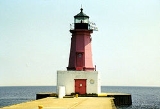
The Menominee North Pier lighthouse
is located in the harbor of Menominee, Michigan
. The station was established in 1877. The current structure and its still operational light was first lit in 1927, and automated in 1972. It is also sometimes called the "Menominee (Marinette) North Pierhead Light".
The foundation is a concrete pier. The 34 feet (10.4 m) tall octagonal cast iron building is marked in a distinctive red, with a black lantern and white base. A Fourth Order Fresnel lens
was originally installed, but was replaced with a modern 300 mm. acrylic optic lens. The original lens is now at Sand Point Light
in Escanaba, Michigan
. The focal plane is 46 feet.
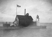
The building originally had a diaphone
fog signal structure attached, and it was later removed. The iron catwalk was removed in 1972 when the light was automated.
This light is paired with a large rear range light. That is denominated the Menominee (Marinette) North Pier light, and is also an active aid to navigation. Its focal plane 59 ft (18 m), and its characteristic is a continuous red light. The tower is a 50 ft (15 m) square pyramidal steel skeletal tower with gallery
. It is painted red, and located on the Menominee North Pier about 600 ft (180 m) from the pierhead light. It may be accessed by walking the pier. The site is open, but the tower is closed. U.S. Coast Guard. USCG 7-21940.
 US 41
US 41
enters Menominee and makes a 90 degree turn onto 10th Street (heading east to west) as it passes through downtown. Go east on 10th Street towards Lake Michigan to 1st street. Turn south onto 1st Street, then turn east onto Harbor Drive. Harbor Drive parallels the lakeshore, ending at a parking lot. A short walk on a wooden walkway leads to the large, flat breakwater.
Lighthouse
A lighthouse is a tower, building, or other type of structure designed to emit light from a system of lamps and lenses or, in older times, from a fire, and used as an aid to navigation for maritime pilots at sea or on inland waterways....
is located in the harbor of Menominee, Michigan
Menominee, Michigan
Menominee is a city in the Upper Peninsula of the U.S. state of Michigan. As of the 2000 census, the city population was 9,131. It is the county seat of Menominee County. Menominee is the fourth-largest city in the Upper Peninsula, behind Marquette, Sault Ste. Marie, and Escanaba...
. The station was established in 1877. The current structure and its still operational light was first lit in 1927, and automated in 1972. It is also sometimes called the "Menominee (Marinette) North Pierhead Light".
The foundation is a concrete pier. The 34 feet (10.4 m) tall octagonal cast iron building is marked in a distinctive red, with a black lantern and white base. A Fourth Order Fresnel lens
Fresnel lens
A Fresnel lens is a type of lens originally developed by French physicist Augustin-Jean Fresnel for lighthouses.The design allows the construction of lenses of large aperture and short focal length without the mass and volume of material that would be required by a lens of conventional design...
was originally installed, but was replaced with a modern 300 mm. acrylic optic lens. The original lens is now at Sand Point Light
Sand Point Light
The Sand Point Lighthouse is located in Escanaba, Michigan, United States, on Lake Michigan's northern shore. Since 1989, is has been an unofficial aid to navigation. Though it is an operational aid to navigation. The restored lighthouse is now open to the public during the summer months...
in Escanaba, Michigan
Escanaba, Michigan
Escanaba is a city in the U.S. state of Michigan, located in the banana belt on the state's Upper Peninsula. As of the 2000 census, the city population was 13,140, making it the third-largest city in the Upper Peninsula after Marquette and Sault Ste. Marie...
. The focal plane is 46 feet.
The building originally had a diaphone
Diaphone
For Diaphone, the Noctuid moth species see Diaphone The diaphone was a noisemaking device best known for its use as a foghorn: it could produce deep, powerful tones able to carry a long distance...
fog signal structure attached, and it was later removed. The iron catwalk was removed in 1972 when the light was automated.
This light is paired with a large rear range light. That is denominated the Menominee (Marinette) North Pier light, and is also an active aid to navigation. Its focal plane 59 ft (18 m), and its characteristic is a continuous red light. The tower is a 50 ft (15 m) square pyramidal steel skeletal tower with gallery
Balcony
Balcony , a platform projecting from the wall of a building, supported by columns or console brackets, and enclosed with a balustrade.-Types:The traditional Maltese balcony is a wooden closed balcony projecting from a...
. It is painted red, and located on the Menominee North Pier about 600 ft (180 m) from the pierhead light. It may be accessed by walking the pier. The site is open, but the tower is closed. U.S. Coast Guard. USCG 7-21940.
Directions
US 41U.S. Route 41
U.S. Route 41 is a north–south United States Highway that runs from Miami, Florida to the Upper Peninsula of Michigan. Until 1949, the part in southern Florida, from Naples to Miami, was U.S...
enters Menominee and makes a 90 degree turn onto 10th Street (heading east to west) as it passes through downtown. Go east on 10th Street towards Lake Michigan to 1st street. Turn south onto 1st Street, then turn east onto Harbor Drive. Harbor Drive parallels the lakeshore, ending at a parking lot. A short walk on a wooden walkway leads to the large, flat breakwater.
External links
- Detroit News, Interactive map on Michigan lighthouses.
- Interactive map of Lights in Northern Lake Michigan, mapped by Google.
- Lighthouse Central, Menominee North Pier Light, The Ultimate Guide to Upper Michigan Lighthouses by Jerry Roach.. (Publisher: Bugs Publishing LLC - 2007). ISBN 978-0-9747977-2-4.
- Lighthouse depot, Menoninee Pier Light.
- Lighthouse friends, Menoninee North Pier Light.
- Michigan Lighthouse Conservancy, Menoninee North Pier Light.
- Map of Michigan Lighthouse in PDF Format.
- Terry Pepper, Seeing the Light, Menoninee Pier Light.
- National Park ServiceNational Park ServiceThe National Park Service is the U.S. federal agency that manages all national parks, many national monuments, and other conservation and historical properties with various title designations...
, Maritime Heritage Inventory of Historic Lights, Menoninee North Pier Light. - Map of lighthouses in western Lake Michigan.