
Maryland Route 925
Encyclopedia
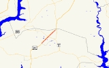
Maryland Route 925 is a state highway
in the U.S. state
of Maryland
. Known as Old Washington Road, the state highway runs 2.49 miles (4 km) from Billingsley Road in White Plains
north to MD 5 Business in Waldorf
. MD 925 and the county-maintained portion of Old Washington Road to the north comprise the old alignment of U.S. Route 301
(US 301) in northern Charles County
. Originally constructed as part of MD 3
and MD 5
in the early 1910s, the highway become part of US 301 in the early 1940s, then was bypassed by the present US 301 divided highway in the mid 1950s. The White Plains–Waldorf portion of the old road was renumbered MD 925 in the early 1960s.
's Popes Creek Subdivision
to the east. Shortly after intersecting Smallwood Drive in St. Charles
, the state highway expands to a three-lane road with center turn lane and enters a commercial area. MD 925 reaches its northern terminus at an intersection with MD 5 Business (Leonardtown Road) in Waldorf. Old Washington Road continues northeast as a county highway, passing through an industrial area before reconnecting with US 301 via Sub-Station Road just south of US 301's intersection with MD 5.
.
{|class=wikitable
!Location
!Mile
!Destinations
!Notes
|-
|White Plains
|0.00
|Billingsley Road to
|Southern terminus; no direct access from eastbound Billingsley Road to northbound MD 925
|-
|St. Charles
|1.19
|Smallwood Drive
|
|-
|Waldorf
|2.49
|
|Northern terminus
State highway
State highway, state road or state route can refer to one of three related concepts, two of them related to a state or provincial government in a country that is divided into states or provinces :#A...
in the U.S. state
U.S. state
A U.S. state is any one of the 50 federated states of the United States of America that share sovereignty with the federal government. Because of this shared sovereignty, an American is a citizen both of the federal entity and of his or her state of domicile. Four states use the official title of...
of Maryland
Maryland
Maryland is a U.S. state located in the Mid Atlantic region of the United States, bordering Virginia, West Virginia, and the District of Columbia to its south and west; Pennsylvania to its north; and Delaware to its east...
. Known as Old Washington Road, the state highway runs 2.49 miles (4 km) from Billingsley Road in White Plains
White Plains, Maryland
White Plains is an unincorporated community located in Charles County in the State of Maryland in the United States of America, just south of Waldorf, Maryland. It is located at latitude 38°35'25" North; longitude 76°56'26" West. The United States Postal Service has assigned White Plains the ZIP...
north to MD 5 Business in Waldorf
Waldorf, Maryland
Waldorf, Maryland is an unincorporated community and census-designated place in Charles County, Maryland, United States. It is south-southeast of Washington, D.C. The population of the census-designated area only was 67,752 at the 2010 census...
. MD 925 and the county-maintained portion of Old Washington Road to the north comprise the old alignment of U.S. Route 301
U.S. Route 301 in Maryland
U.S. Route 301 in Maryland is a major highway that runs from Delaware to the Governor Harry W. Nice Memorial Bridge into Virginia. It passes through three of Maryland's four main regions: the Eastern Shore, the Baltimore-Washington Metropolitan Area, and Southern Maryland...
(US 301) in northern Charles County
Charles County, Maryland
Charles County is a county in the south central portion of the U.S. state of Maryland.As of 2010, the population was 146,551. Its county seat is La Plata. This county was named for Charles Calvert , third Baron Baltimore....
. Originally constructed as part of MD 3
Maryland Route 3
Maryland Route 3, also part of Robert Crain Highway, is the designation given to the former alignment of U.S. Route 301 from Bowie, Maryland, USA, to Baltimore. It is named for Robert Crain of Baltimore.-Route description:...
and MD 5
Maryland Route 5
Maryland Route 5 is a long state highway that runs north–south in the U.S. state of Maryland. The highway runs from Point Lookout in St. Mary's County north to the Washington, D.C. border in Suitland, Prince George's County....
in the early 1910s, the highway become part of US 301 in the early 1940s, then was bypassed by the present US 301 divided highway in the mid 1950s. The White Plains–Waldorf portion of the old road was renumbered MD 925 in the early 1960s.
Route description
MD 925 begins at an intersection with Billingsley Road in White Plains, just east of the latter highway's intersection with US 301 (Robert Crain Highway). There is no direct access to northbound MD 925 from eastbound Billingsley Road. MD 925 heads northeast through a residential area, paralleling US 301 to the west and CSXCSX Transportation
CSX Transportation operates a Class I railroad in the United States known as the CSX Railroad. It is the main subsidiary of the CSX Corporation. The company is headquartered in Jacksonville, Florida, and owns approximately 21,000 route miles...
's Popes Creek Subdivision
Popes Creek Subdivision
The Pope's Creek Subdivision is a CSX Transportation railroad line in Maryland, running from Bowie to Morgantown and the Chalk Point Generating Station.- History :...
to the east. Shortly after intersecting Smallwood Drive in St. Charles
St. Charles, Maryland
St. Charles is a census-designated place and planned community in Charles County, Maryland, United States. It is south-southeast of Washington, D.C., from northern Virginia and immediately south of Waldorf, which is the mailing address....
, the state highway expands to a three-lane road with center turn lane and enters a commercial area. MD 925 reaches its northern terminus at an intersection with MD 5 Business (Leonardtown Road) in Waldorf. Old Washington Road continues northeast as a county highway, passing through an industrial area before reconnecting with US 301 via Sub-Station Road just south of US 301's intersection with MD 5.
History
Old Washington Road is the original alignment of US 301 from White Plains through Waldorf to the Prince George's County line. The route was marked for improvement as one of the original state roads by the Maryland State Roads Commission in 1909. The highway between White Plains and the county line was constructed as a 14 feet (4.3 m) gravel road in 1912. The highway was designated MD 3 for its whole length and MD 5 north of Waldorf in 1927. By 1930, the highway was the most heavily traveled highway in Charles County, so the road was widened to 20 feet (6.1 m) with concrete shoulders and resurfaced with bituminous concrete. Around 1948, the route, now part of US 301, was widened to 24 feet (7.3 m). The expanded highway still was unable to handle the traffic burden, so in 1952 a divided highway bypass of Old Washington Road was started from the Prince George's County end. The new US 301 divided highway reached Waldorf by 1954 and was completed to White Plains in 1956. Old Washington Road originally kept the MD 3 designation. However, by 1961, Old Washington Road was designated MD 925 south of Waldorf and transferred to county maintenance north of Waldorf.Junction list
The entire route is in Charles CountyCharles County, Maryland
Charles County is a county in the south central portion of the U.S. state of Maryland.As of 2010, the population was 146,551. Its county seat is La Plata. This county was named for Charles Calvert , third Baron Baltimore....
.
{|class=wikitable
!Location
!Mile
!Destinations
!Notes
|-
|White Plains
White Plains, Maryland
White Plains is an unincorporated community located in Charles County in the State of Maryland in the United States of America, just south of Waldorf, Maryland. It is located at latitude 38°35'25" North; longitude 76°56'26" West. The United States Postal Service has assigned White Plains the ZIP...
|0.00
|Billingsley Road to
|Southern terminus; no direct access from eastbound Billingsley Road to northbound MD 925
|-
|St. Charles
St. Charles, Maryland
St. Charles is a census-designated place and planned community in Charles County, Maryland, United States. It is south-southeast of Washington, D.C., from northern Virginia and immediately south of Waldorf, which is the mailing address....
|1.19
|Smallwood Drive
|
|-
|Waldorf
Waldorf, Maryland
Waldorf, Maryland is an unincorporated community and census-designated place in Charles County, Maryland, United States. It is south-southeast of Washington, D.C. The population of the census-designated area only was 67,752 at the 2010 census...
|2.49
|
|Northern terminus